Prosper in a dynamic world
Search

A cloudy and rainy year thus far for Sydney

It has been a cloudy and rainy year thus far for Sydney, with 28 of the 55 calendar days recording rainfall. This unusual summer has seen more days of rainfall than not.

The wet weather is set to continue, with large multi-day rainfall accumulations predicted for the central and northern NSW coast from today through to Monday, March 1st, including Sydney. The heaviest falls are likely to occur during today and on Saturday.

So how cloudy was it? 

It has been a cloudier than average beginning to the year for Sydney with only two other cloudier beginnings to the year recorded in the last decade.

The week of January 26 to February 2nd has been the cloudiest week of the year. During this week, Sydney saw less than two and a half hours of sunlight on average per day. In the past decade there have only been two cloudier weeks at this time of year.

The largest daily rainfall total during the same week (week ending February 2nd) was 29.6mm at Sydney Observatory Hill on Saturday the 30th of January. The tropics were particularly active during this week feeding moisture into a low pressure trough on January 30th. As such low solar irradiance was observed for eastern New South Wales (yellow and black in figure 1).


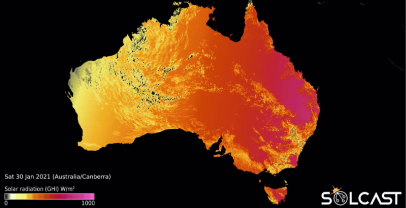
Figure 1: Solcast’s global horizontal irradiance on the 30th of January 2021

During such weather conditions it is especially important for the Renewable Energy industry to have excellent solar forecasting solutions in order to be able to maximise profit and minimise risk. If you want to know more about Weatherzone’s and Solcast’s market leading capabilities in this field please visit our websites (https://business.weatherzone.com.au/; www.solcast.com).

Latest news

Satisfy your weather obsession with these news headlines from around the nation, and the world.

Tropical Cyclone Fina to pass near Darwin this weekend – possible disruptions to key industries

Tropical Cyclone Fina has turned towards the Northern Territory coast and is expected to make landfall over the Top End on Friday, November 21, 2025. The system could then regain strength over the warm Van Diemen Gulf, before passing close to Darwin on the weekend. The last tropical cyclone to directly impact Darwin was Tropical […]

High tropical cyclone risk near northern Australia this week

A tropical low currently developing over the Timor Sea has a high chance of becoming a tropical cyclone later this week, with a possibility of landfall somewhere in the Northern Territory or Western Australia. Key industries could be impacted including Ports, Mining, Transport, and Agriculture. The satellite images below show cloud circulating around the developing […]

Madden-Julian Oscillation increasing tropical cyclone potential for northern Australia industries

Sea surface temperatures exceeding 31°C off the coast of northern Australia and an active phase of the Madden-Julian Oscillation (MJO) are increasing the likelihood of early-season tropical cyclone activity, with hints of the season’s first tropical cyclone coming as early as next week. Tropical cyclones require sea surface temperature of 26.5°C or warmer to develop, […]

Tropical cyclone season begins with warm oceans surrounding northern Australia

The 2025-26 tropical cyclone season has begun with abnormally warm oceans surrounding northern Australia, signalling an increased risk for severe tropical cyclones in the coming months. The Australian tropical cyclone season runs from November 1 to April 30. During this six-month period, there are usually about 9 to 10 tropical cyclones in the Australian region, […]