Prosper in a dynamic world
Search

Total Lightning Network – Keeping Your Business Safe

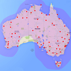
The Weatherzone Total Lightning Network (WZTLN) is Australia’s most advanced solution for maximising the safety of outdoor workers, whilst minimising downtime. Additionally it can be used by the Insurance industry to warn customers of severe weather, so that losses can be reduced through the moving of cars indoors and similar evasive action.

Weatherzone utilises the world leading Earth Network’s technology, which is a superior solution in the detection accuracy for both cloud-to-ground and cloud-to-cloud strikes than any other method.

This ‘total lightning’ aspect of the WZTLN provides the earliest possible alert of impending danger, as cloud to cloud strikes are often the precursor to the more life-threatening cloud to ground variety.

Additionally, researchers have shown that in-cloud lightning often serves as an early indicator of severe weather, from heavy rain to hail to damaging winds.

Therefore the use of a ‘total lightning’ solution can provide the earliest possible guidance on threatening weather through Weatherzone’s Dangerous Thunderstorm Alerts.

Since its launch in late 2014, the WZTLN has been utilised across Australia by various industry sectors, including;

  • Mining
  • Construction
  • Ports and Transport Networks
  • Aviation
  • Electricity Networks
  • Insurance

The benefit of the network is keeping workers safe, whilst maintaining a balance with productivity.

Latest news

Satisfy your weather obsession with these news headlines from around the nation, and the world.

Tropical Cyclone Fina to pass near Darwin this weekend – possible disruptions to key industries

Tropical Cyclone Fina has turned towards the Northern Territory coast and is expected to make landfall over the Top End on Friday, November 21, 2025. The system could then regain strength over the warm Van Diemen Gulf, before passing close to Darwin on the weekend. The last tropical cyclone to directly impact Darwin was Tropical […]

High tropical cyclone risk near northern Australia this week

A tropical low currently developing over the Timor Sea has a high chance of becoming a tropical cyclone later this week, with a possibility of landfall somewhere in the Northern Territory or Western Australia. Key industries could be impacted including Ports, Mining, Transport, and Agriculture. The satellite images below show cloud circulating around the developing […]

Madden-Julian Oscillation increasing tropical cyclone potential for northern Australia industries

Sea surface temperatures exceeding 31°C off the coast of northern Australia and an active phase of the Madden-Julian Oscillation (MJO) are increasing the likelihood of early-season tropical cyclone activity, with hints of the season’s first tropical cyclone coming as early as next week. Tropical cyclones require sea surface temperature of 26.5°C or warmer to develop, […]

Tropical cyclone season begins with warm oceans surrounding northern Australia

The 2025-26 tropical cyclone season has begun with abnormally warm oceans surrounding northern Australia, signalling an increased risk for severe tropical cyclones in the coming months. The Australian tropical cyclone season runs from November 1 to April 30. During this six-month period, there are usually about 9 to 10 tropical cyclones in the Australian region, […]