
Australian ports and marine pilots can expect a season of shifting wind and swell patterns through winter and spring 2026, as a developing El Niño brings the likelihood of drier conditions and more variable operating windows across the country’s coastline.
Will El Niño develop in 2026?
There are clear signs that an El Niño pattern is becoming established in the tropical Pacific Ocean, with several key oceanic and atmospheric indices tipping over El Niño thresholds in recent weeks.
While the Pacific Ocean region is still only in early stages of this ocean-atmosphere coupling, there is strong consensus between long-range computer models that El Niño will strengthen in the coming months and persist through the Southern Hemisphere’s winter and spring. Current forecasts suggest that this El Niño could be a strong event.
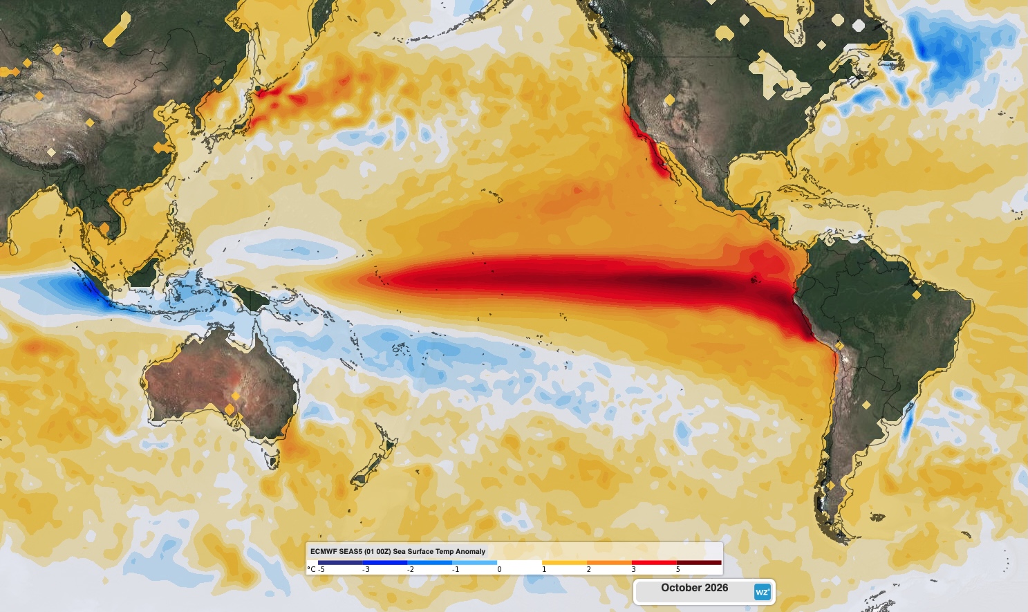
Image: Forecast sea surface temperature anomaly in October 2026, showing a distinctive El Niño pattern in the Pacific Ocean. Source: Weatherzone.
In addition to El Niño, there are also signs that a positive Indian Ocean Dipole (IOD) could develop in winter or spring. While there is a large amount of uncertainty regarding the IOD in the coming months, it will most likely be neutral or positive during winter-spring 2026.
How will El Niño affect Australia this year?
Every El Niño event is different, and they do not always have the same impact on Australian weather. However, there are some types of weather that become more likely in Australia when El Niño is underway. El Niño typically promotes:
- Above average daytime temperatures across most of Australia, particularly in the southern half of the country
- Below-normal minimum temperature across most of Australia in winter and early spring.
- Below-average rainfall, especially in the east and north
- Higher likelihood of drought
- Increased bushfire risk
- Delayed monsoon onset in northern Australia
- Decreased alpine snow depths and a shorter snow season
If a positive IOD does develop, this will further enhance the likelihood of abnormally dry and warm weather in Australia during winter and spring.
This year’s developing El Niño and possible positive IOD are already beginning to influence the outlooks for winter and spring.
Atmospheric pressure
One of the main ways El Niño influences weather patterns in Australia is by promoting higher mean sea level pressure and reducing the prominence of low pressure systems and cold fronts. This happens because El Niño weakens trade winds in the tropical Pacific region, resulting in less warm and moisture-laden air flowing towards Australia from the northeast. These weaker trade winds cause less rising air in the Australian region, with descending air becoming more prominent, resulting in higher mean sea level pressure.
As a general rule of thumb, high pressure is associated with dry and settled weather, while low pressure is associated with clouds, rain and snow. High pressure near southern Australia can also block cold fronts, reducing the frequency and intensity of cold outbreaks during winter.
Abnormally high sea level pressure is likely to influence Australia’s weather in winter and spring this year. This pattern suggests that cold outbreaks may occur less frequently and be less intense than usual in the coming months.
The following maps show the forecast sea level pressure anomalies between June and November 2026. The orange-brown shaded areas are expected to see higher-than-normal mean sea level pressure, while blue shaded areas are expected to have below-average mean sea level pressure.
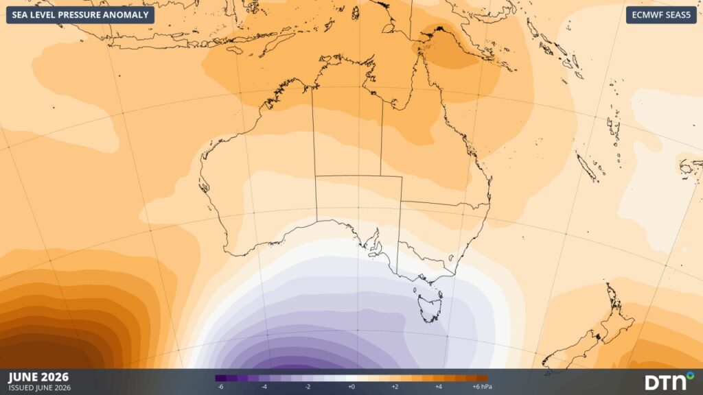
Image: Forecast mean sea level pressure anomaly in June 2026. Source: DTN/ ECMWF SEAS5
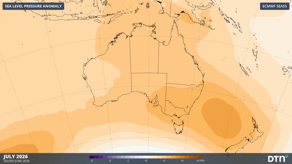
Image: Forecast mean sea level pressure anomaly in July 2026. Source: DTN/ ECMWF SEAS5
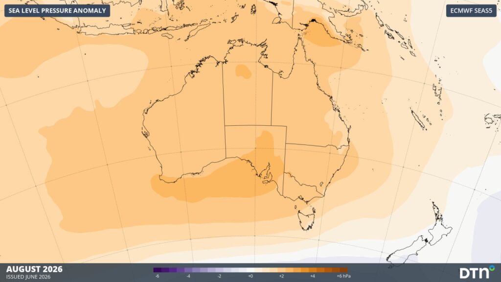
Image: Forecast mean sea level pressure anomaly in August 2026. Source: DTN/ ECMWF SEAS5
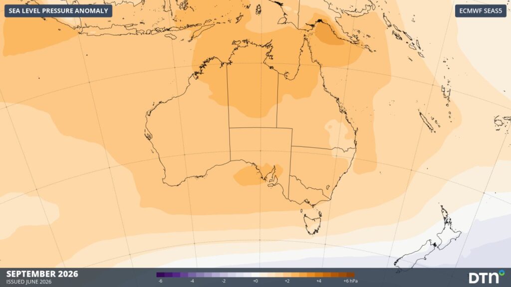
Image: Forecast mean sea level pressure anomaly in September 2026. Source: DTN/ ECMWF SEAS5
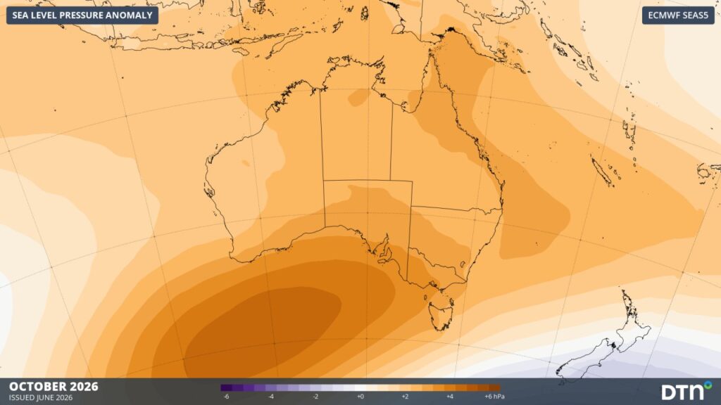
Image: Forecast mean sea level pressure anomaly in October 2026. Source: DTN/ ECMWF SEAS5
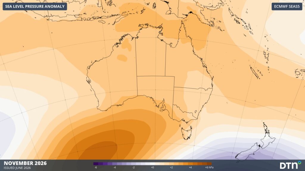
Image: Forecast mean sea level pressure anomaly in November 2026. Source: DTN/ ECMWF SEAS5
Wind
The mean sea level pressure pattern outlined above has a direct bearing on wind conditions through the outlook period. As shown on the June and July pressure anomaly maps, a region of below-average pressure persists to the south and southeast of the continent. This area of lower pressure is the key driver behind above-average wind speeds expected across Australian waters in June, continuing into July across southern and southeastern regions.
By August, the pressure maps show this region of below-average pressure weakening as the broader high-pressure pattern associated with El Niño becomes more dominant across the continent. In line with this shift, winds may trend back toward average or below-average levels during August.
Moving into spring, some caution is warranted despite the broader high-pressure trend shown in the mean sea level pressure maps above. El Niño is correlated with a negative Southern Annular Mode (SAM), which could see winds increase again across southern regions.
Swell
Swell conditions broadly track the wind pattern described above, given their shared link to the pressure anomalies. The same area of below-average pressure to the south and southeast that drives above-average winds through July is also likely to amplify Southern Ocean swell, with flow-on effects for southern and southeastern approaches and anchorages.
As the pressure maps show high pressure building through August and the lower-pressure area to the south easing, swell along the south coast may ease in turn. The east coast may see a prevailing easterly swell under the influence of high pressure and dominant easterly winds.
Coming into spring, a renewed increase in swell activity is possible under the influence of El Niño and potentially negative SAM.
Northern Australia
Conditions across the north are likely to diverge from the rest of the country. The weakened trade winds associated with El Niño typically translate to lighter prevailing winds and reduced wave energy across northern waters, which may offer more favourable operating windows for the northern ports.
El Niño years also tend to bring fewer tropical cyclones in the Australian region, potentially easing disruptions during cyclone season. It is also typically associated with a delayed monsoon onset, shifting the timing of the wet season, as well as reduced rainfall and storm activity overall.
Salinity and underkeel clearance
Below-average rainfall is forecast across most of Australia over the coming months, particularly in the east and north under the influence of El Niño. Reduced rainfall means reduced freshwater inflow into many ports, harbours and estuaries, which tends to push up salinity levels in port approaches and estuarine waters.
Higher salinity means higher water density, providing marginally greater buoyancy for vessels transiting these areas. For pilots manoeuvring through tide-limited or shallow ports, this small increase in water density can be a meaningful factor in underkeel clearance calculations.
Despite this overall drier trend, the east coast may still see significant rainfall events through summer, with warm seas providing additional moisture that could fuel rain and thunderstorms. These events could temporarily reduce salinity in port approaches and marginally affect vessel buoyancy.
Pilots and port operators should treat the conditions described here as a planning guide rather than a fixed forecast and continue to monitor updated outlooks and short-range forecasts as the season progresses.

DTN APAC is returning to the Australasian Marine Pilots Institute (AMPI) Regional Ports & Pilotage Conference in Darwin, Northern Territory, June 14-17, 2026. Our Head Communications Meteorologist, Ashleigh Madden, will be presenting an exclusive Winter to Spring Outlook, covering how El Niño is shaping the ‘base conditions’ for Australian port operations this season, including wind regimes, swell, cyclones, storm risk, and more. Be sure to check out the speaker session at 3:20pm ACST on Tuesday, June 16.
Can’t make the event? Connect with our Senior Sales Executive, Philip Perkins, today to learn more about our industry-leading weather solutions and alerting to minimise risk for offshore, ports, and logistics operations.


