Intense heat from bushfires during elevated fire danger days can trigger fire-induced pyrocumulonimbus thunderstorms that ignite additional fires.
In early January 2026, an extreme heatwave sweeping over southeastern Australia brought catastrophic fire danger to Victoria. Intensely hot bush and grass fires spread erratically and quickly in hot, dry and gusty winds, with pyrocumulonimbus generating lightning, sparking more fires. During these intense fire weather conditions, meteorologists, fire management agencies and industries rely on DTN APAC services to detect, visualise and predict where, when and how fires will behave.
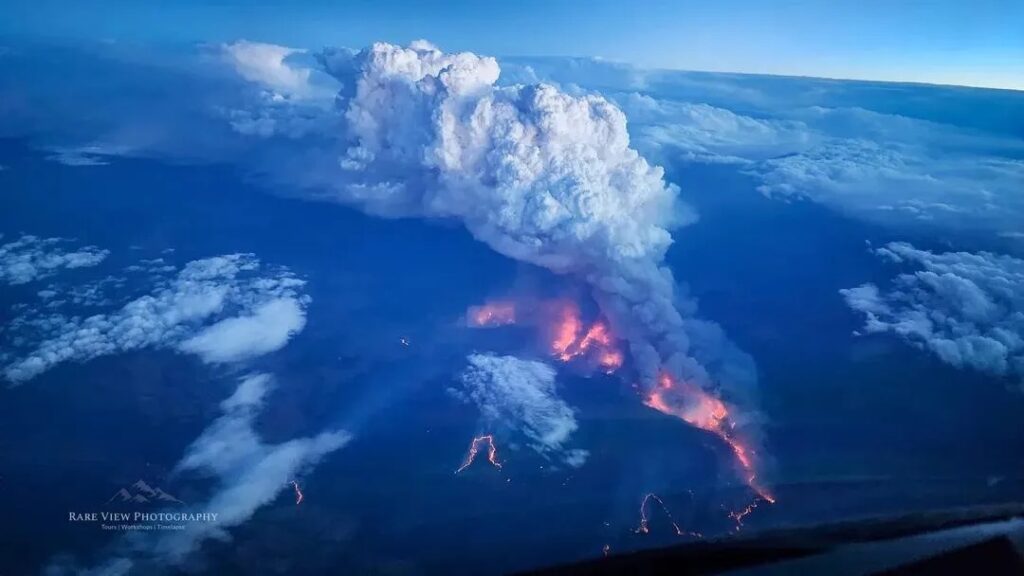

Image: Active firegrounds, bushfire smoke and pyrocumulus from a bushfire near Euroa, Victoria, on January 9, 2026. Source: Levin Barrett (Threads / @rareview.photography)
Catastrophic Fire Danger Rating (FDR) and Fire Behaviour Index (FBI)
The Australian Fire Danger Rating System (AFDRS) is a four-tiered national rating system that describes the potential level of danger on a given day, should a fire start.
Australia’s daily fire danger ratings are calculated using observations about the current state of the bushfire fuel, combined with forecasts from weather and fire behaviour models.
There are four levels in the AFDRS, with each rating also carrying a simple message to encourage appropriate action to protect lives:
- Moderate: Plan and prepare.
- High: Prepare to act.
- Extreme: Take action now to protect your life and property.
- Catastrophic: For your survival, leave bush fire risk areas.
On days with moderate fire danger, people and businesses are advised to stay up to date and be ready to act if there is a fire. These are days with a Fire Behaviour Index (FBI) value between 12 and 23.
High fire danger means there is a heightened risk, and people and organisation environmental risk managers should be alert for fires in their area and decide what they will do if a fire starts. If a fire does start, life, property and assets may be at risk. The safest option is to avoid bushfire risk areas on these days. These are days with a Fire Behaviour Index (FBI) value between 24 and 49.
When there is extreme fire danger, conditions are dangerous, and people and industries should reconsider travel and operations through bushfire risk areas. It is important to check bushfire plans and ensure that properties and assets are fire ready. If a fire starts, immediate action is essential. If any people or property are not prepared to the highest level under these conditions, relocation to a safer location well before the fire impacts is needed. These are days with a Fire Behaviour Index (FBI) value between 50 and 99.
The highest level of fire danger in Australia is catastrophic fire danger. These are the most dangerous conditions for a fire. Life may depend on the decisions made, even before there is a fire. Preparation and relocation of personnel and assets should be completed by early in the morning or the night before if possible. Homes and some buildings cannot withstand fires in these conditions and if a fire starts, evacuation may no longer be possible, and help may not be available. These are days with a Fire Behaviour Index (FBI) value of 100 or higher, and feature weather conditions comparable to some of Australia’s worse fire days such as Black Friday in 1939, Ash Wednesday in 1983, Black Saturday in 2009, and days during the Black Summer of 2019-20.
While fire danger ratings give useful information about the potential level of danger, they don’t guarantee that a fire will start, nor do they give any information about current fires.
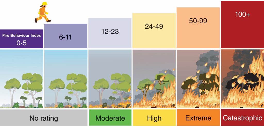
Image: Australian fire danger ratings and corresponding FBI values. Source: AFAC
Catastrophic fire danger ratings were forecast on Friday, January 9, 2026 for parts of northern and western Victoria. FBI values reached catastrophic levels at various locations in Victoria and southeast South Australia as hot, dry and gusty northwesterly winds blew into southeastern Australia. Peak FBI values reached:
- 121 at Mount Gellibrand
- 120 at Horsham
- 113 at Longerenong
- between 100 and 110 at 11 other locations, including Melbourne Airport and Avalon Airport
What are pyrocumulus (and pyrocumulonimbus) and how can they trigger more fires?
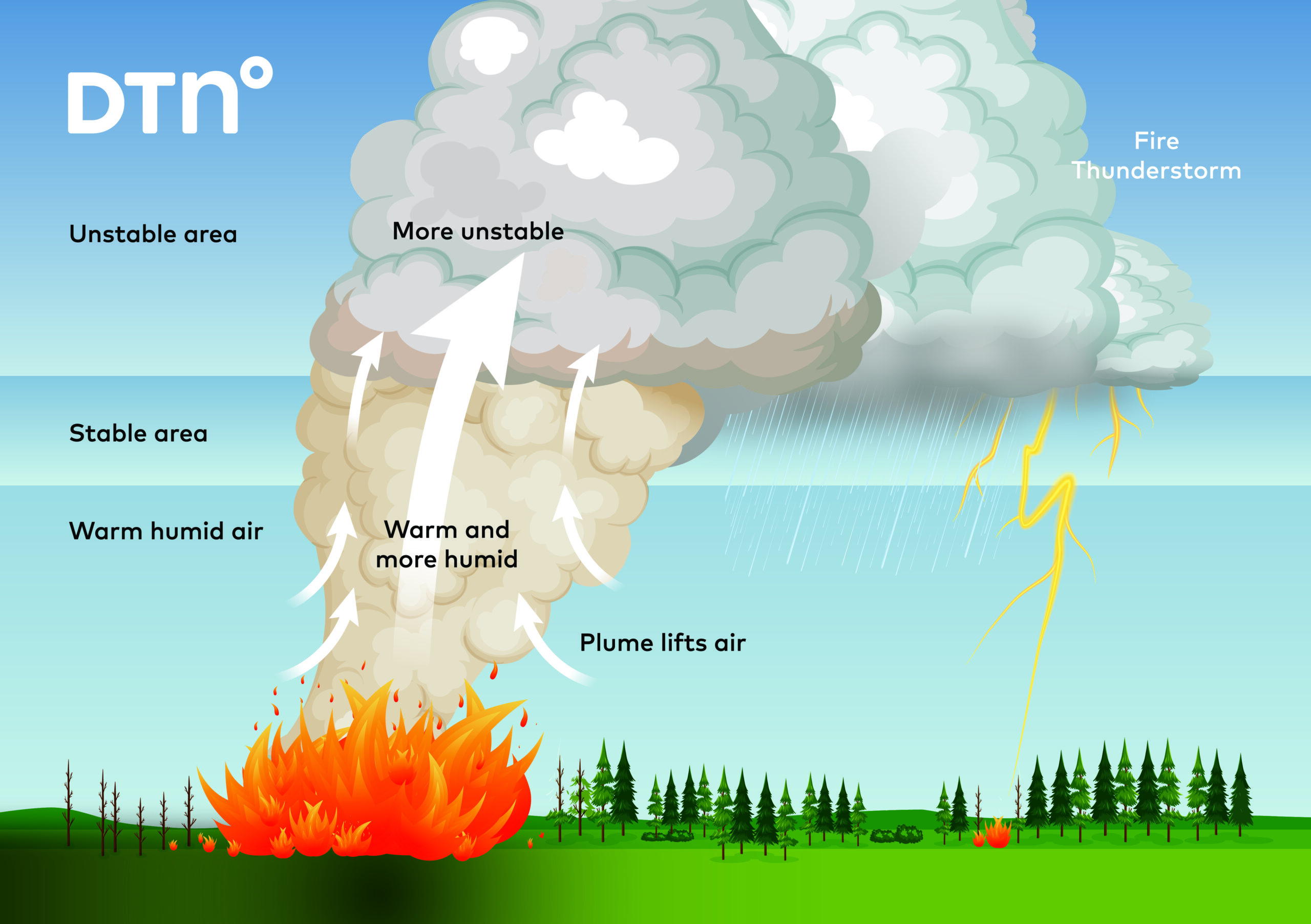
Pyrocumulonimbus (also known as cumulonimbus flammagenitus) are fire-induced thunderstorm clouds.
Similarly to regular thunderstorms, which need a trigger to push warm and humid air into unstable parts of the atmosphere, pyrocumulonimbus spawn from the intense bushfire heat piercing the warm and moist lower atmosphere air through a stable layer into the unstable atmosphere. From there, the warm and moist air can rise (and cool) into unstable cumulus and cumulonimbus (thunderstorm) clouds.
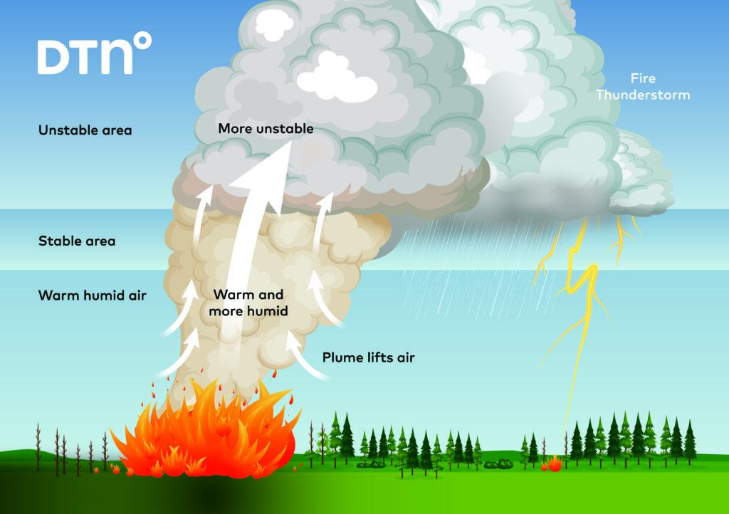
Image: Intense heat from fires lifts warm and moist air into unstable parts of the atmosphere, generating fire-induced pyrocumulonimbus thunderstorm clouds. Source: DTN
Once developed into a full-fledged pyrocumulonimbus, normal thunderstorm behaviour leads to lightning through friction between the updrafts and downdrafts of the cloud. During extreme and catastrophic fire weather days, the lower parts of the atmosphere are nearly always dry. Most of the rain from pyrocumulonimbus evaporates under the cloud, with only lightning reaching the ground.
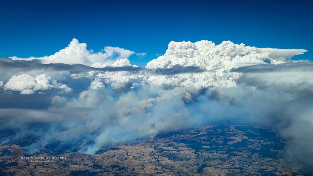
Image: Bushfire smoke and pyrocumulonimbus from a bushfire near Euroa, Victoria, on January 9, 2026. Source: Levin Barrett (Threads / @rareview.photography)
Dry lightning from pyrocumulonimbus clouds is exceptionally dangerous as new fires can quickly ignite. Along with dry lightning igniting new fires, pyrocumulonimbus can also bring:
- Erratic and unexpected direction and intensity changes: the powerful down drafts bring changing gusty winds in any direction, which fan bush and grass fires, making fire management and containment exceptionally difficult.
- Spot fires: ambers from fires can be drawn into the strong updrafts and ignite spot fires far downwind, which greatly increases the area of concern and monitoring for fire management agencies.
Climate change is also changing temperature, fuel, moisture and weather patterns, indicating increasingly earlier starts to bushfire seasons across southern and eastern Australia, with more intense conditions during the peak fire danger seasons. Pyrocumulonimbus and dry lightning has also become a more common phenomenon over recent decades (Canberra in 2003, 2009 Black Saturday, 2019-20 Black Summer). This is indicative of a long-term trend across southeastern Australia that could become increasingly common.
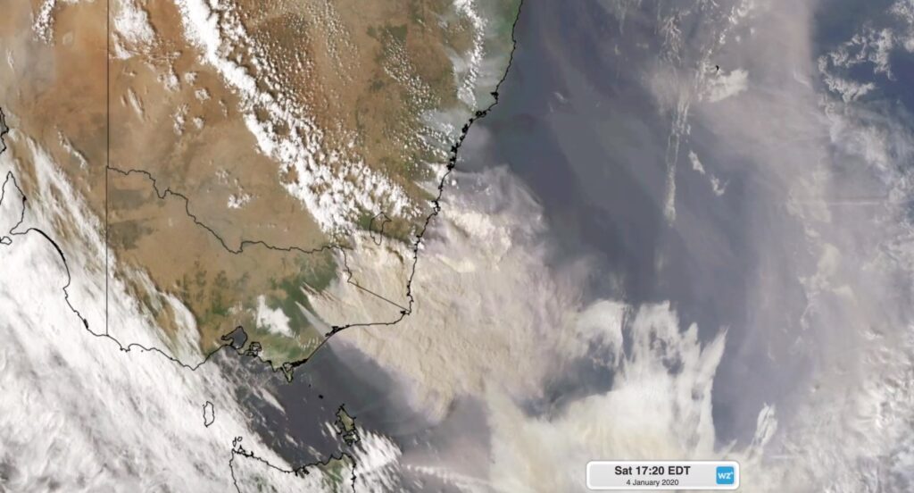
Image: Smoke from fires in eastern Victoria being blown across the Tasman Sea in early January 2020.
How DTN helps fire agencies detect and monitor pyrocumulus and fire risk
Ahead of peak fire danger periods, DTN APAC’s Opticast forecasting system highlights days and hours of dangerous fire danger. This allows industries such as power utilities, mining and transport to assess and prepare for hazardous fire danger days well in advance, and know when it’s safe to return to normal.
Our trusted nowcasting and forecasting system, OpticastTM, is independently proven to outperform other industry models, allowing you to respond rapidly to changing conditions. Opticast can ingest data from your on-site weather observation equipment, ensuring your forecast is customised to your local microclimate. From nowcasting and 14-day forecasting to seasonal outlooks, you have powerful, hyper-local weather alerting and intelligence, giving you decisive confidence when it’s most needed.
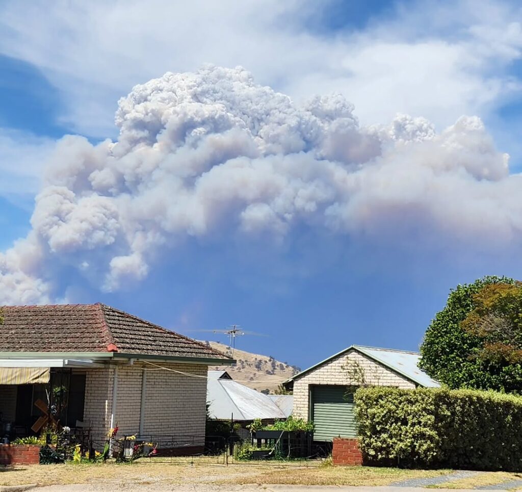
Image: Smoke from a bushfire near Tallangatta, Victoria, on January 9, 2026. Source: Instagram / @thetrippinfoodies
When dangerous fire weather conditions are occurring, DTN APAC’s Stormtracker Dashboard is an essential detection and monitoring tool used by affected businesses and fire management agencies. Using satellite, lightning detection, radar and weather observation data, areas of dangerous fire danger, new and active fires, and pyrocumulonimbus can be detected and monitored in real time.
As seen in the video below, the smoke plume of an active fire burning over Victoria’s northwest on Friday, January 9, 2026, can be seen on satellite imagery. Overlaid FBI observations can be seen reaching catastrophic levels as hot, dry and gusty northwesterly winds pushed across Victoria. Throughout the afternoon, the gusty southwesterly wind change moved over the fire grounds, dangerously fanning flames into a new direction.
Video: Satellite, radar and lightning imagery as seen on the DTN APAC Stormtracker Dashboard showing catastrophic fire weather dangerously spreading an active fire over Victoria’s northwest on Friday, January 9, 2026. Source: DTN
Focusing on the fire burning in the northwest of the state, pyrocumulus and then pyrocumulonimbus are detected by satellite and radar imagery. Lightning is then detected by DTN’s Total Lightning Network, providing pinpoint accuracy on possible dry lightning strikes that might ignite the next fire. As the southwesterly change moves over the region, the new fire ground to the southeast can be seen through the new plume of smoke. Country Fire Authority (CFA) active fires overlaid also show the location of the new fire ground.
Video: Satellite, radar and lightning imagery as seen on the DTN APAC Stormtracker Dashboard showing pyrocumulonimbus cloud from a fire in Victoria’s Mallee region sparking another fire downwind on a dangerous fire weather day on Friday, January 9, 2026. Source: DTN
The catastrophic fire weather across the state led to nearly 100,000 customers without power as heat and nearby fires tripped electrical utility networks. As much as 400,000 hectares were burnt in the state’s biggest fire emergency since the Black Summer, with one person tragically killed and more than 350 homes or buildings destroyed.
The fatality occurred in the Longwood Fire which covered the largest area of any bushfire in the emergency. Satellite imagery reveals a large patch of scorched countryside approximately halfway between Mansfield and Seymour, just south of the actual town of Longwood.
Video: Satellite short wave infrared view of the scar left from the Longview fire from before on January 6 and after on January 11, 2026. Source: DTN
DTN APAC serves the forestry and emergency sectors, delivering trusted weather data and severe weather alerting to maintain safety, protect your assets and underpin your planning.
See our Case Study on how Tasmania Fire Service (TFS) improved lightning detection and continued optimising preparations for challenging fire seasons ahead with DTN APAC’s full suite of solutions.
Learn more about our large range of industry leading products and services or email us at sales.apac@dtn.com


