Wind power generation has reached record levels as a series of powerful cold fronts sweep over Australia’s southeast.
Most of Australia’s wind farms are located in South Australia, Victoria and NSW where cold fronts frequently bring periods of high wind energy.
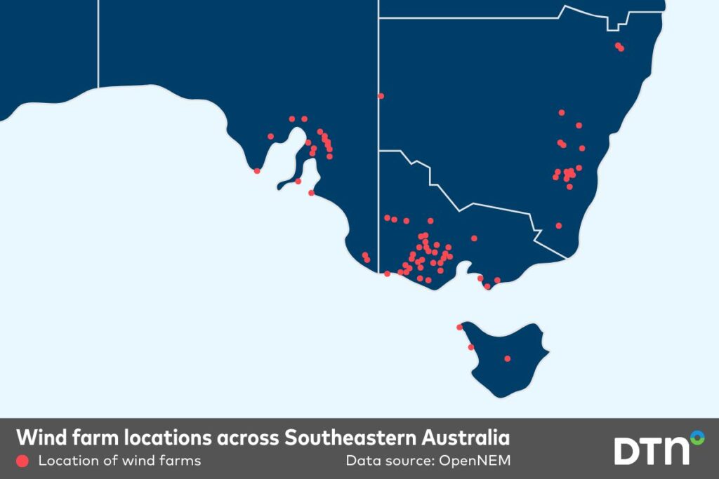
Image: wind farm locations across southeastern Australia.
A series of powerful cold fronts linked to low pressure over the Great Australian Bight and Southern Ocean are crossing southeastern Australia. Wind speeds are reaching 50-70 km/h, with gusts to 70-90 km/h over broad areas of South Australia, Victoria and NSW, with alpine areas experiencing gusts to 130 km/h. Some notable wind gusts up to 10am AEST on Tuesday included:
- 128km/h at Mount Hotham, Vic
- 122 km/h at Thredbo Top Station, NSW
- 117 km/h at Mount Buller, Vic
- 107 km/h at kunanyi / Mount Wellington, Tas
- 93 km/h at Murrurundi Gap, NSW
- 89 km/h at Minlaton airport, SA
Video: 10 metre winds over southeastern Australia between Monday, June 23, and Thursday, June 26.
Strong and continuous wind power is being harnessed by the wind farms in the region, leading to the National Electricity Market’s (NEM) highest wind generation over any day according to OpenNEM, with 191,268 MWh generated on Monday, June 23, 2025. This record was surpassed by nearly 20,000 MWh the next day, on June 24, 2025, with 211,084 MWh of power generated by wind energy. The NEM also set its highest hourly wind generation on Monday evening, with 9,491 MWh generated in the hour to 10:35pm, as seen below.
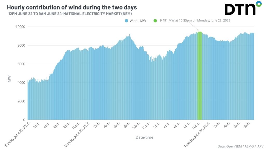
Image: Observation of hourly wind energy generation (updated every 5 minutes) across the NEM from 12pm June 22 to 9am June 24, highlighted in green is the time of record wind energy production at 10:35pm Monday, June 23, 2025. Data source: OpenNEM
This surge of high wind power comes approximately a month after the last strong wind outburst, with 8,526 MWh generated on the evening of Monday, May 26, 2025. In terms of daily generation, this new daily record beats the previous 174,971 MWh set on May 30, 2024, by over 16,297 MWh and then over 35,000 MWh on the Tuesday, June 24, 2025. Some other notable records set over the past few days include:
- Consecutive highest wind generation in Queensland on Saturday, June 21, and Sunday, June 22, with 1,165 MWh and 1,274 MWh, respectively.
- Highest wind generation over a day in Queensland on Sunday, June 22, with 23,696 MWh.
- Highest wind generation over a day in Victoria on Monday, June 23, and Tuesday, June 24, with 93,226 MWh and 94,422 MWh, respectively.
- Highest wind generation in Victoria on the afternoon of Monday, June 23, with 4,418 MWh.
- Highest renewable generation over a day in Victoria on Tuesday, June 24, with 100,565 MWh.
- Highest wind generation in NSW early on Wednesday, June 25, with 2,405 MW.
Another pair of windy days
Satellite imagery below shows the second front is only starting to cross into South Australia, so ample wind energy production is expected over the remainder of Tuesday, and most of Wednesday.
Video: Satellite loop over southeastern Australia on Tuesday, June 24, 2025.
The DTN APAC wind generation forecast which is supplied to major energy operators in Australia show’s that the NEM is coming off a forecast peak from early on Tuesday (seen in the graph above) with a peak of 9,418 MWh at 7:20am, just 73 MWh shy of the record set the night before. Wind generation is forecast to see another surge later on Tuesday.
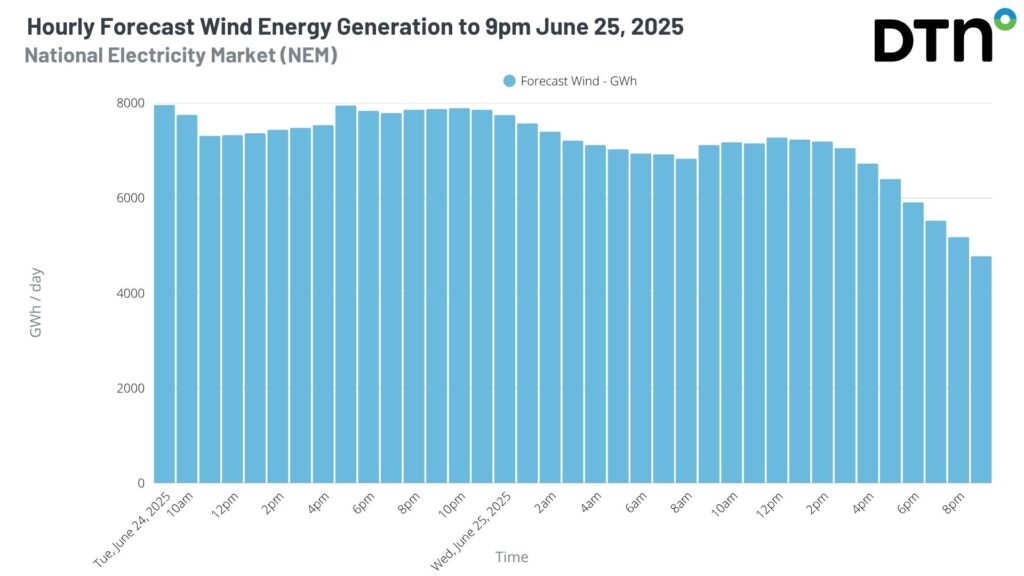
Image: hourly wind generation output for the NEM from the DTN forecast until 9pm on Wednesday, June 25, 2025.
Continuous high wind energy output could also rival the highest daily wind energy record set on Monday, with current output forecast to top out at 185,670 MWh for Tuesday.
A cold polar airmass moving into the southeast will bring a surge of energy demand between Tuesday and Thursday. Wind energy has, however, been contributing between 25 and 40% of the total energy output of the NEM since Monday – helping alleviate the need for non-renewable energy sources during this period of high demand.
Low wind power on the horizon
High pressure will strengthen rapidly over southeastern Australia on Thursday, June 26, as the fronts move out into the Tasman Sea. Wind farm production can be seen plummeting from Thursday with the high bringing significantly lighter winds.
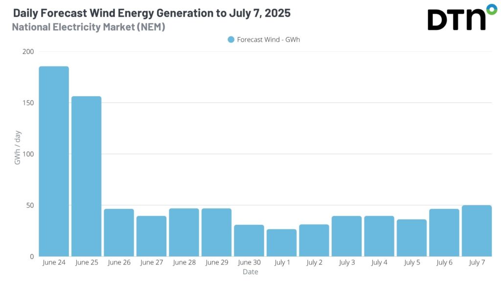
Image: Daily wind farm generation output for the NEM from the DTN forecast over the next 14 days.
The above wind energy forecast comes from DTN APAC’s Opticast, which provides wind generation forecasts for individual wind farms, at the state level and for the NEM at daily and hourly resolution out to 14 days. Opticast is an ultra-local forecasting system, independently proven to be the best performing of its type in Australia, allowing you to plan weeks in advance for high or low wind generation across the NEM, your state and/or individual wind farms.
How DTN APAC helps the renewable wind energy industry

Your customizable Energyzone interface and Weatherguard app will provide access to the Total Lightning Network as well as centralized data from state and territory fire agencies, the Bureau of Meteorology, and over 30 national and international private and state organisations. This enables full situational awareness of weather conditions and fire risk, as well as severe weather alerting via text, email and phone call, so your staff can respond effectively when required. Together we can keep your staff and assets safe, and efficiency high.
DTN APAC also offers seasonal and long-term outlooks covering wind, rainfall and extreme heat out to 12 months into the future. With renewables making up more of Australia’s energy mix every year, we want to support your business to make informed critical decisions and improve your overall generation and safety.
Learn more about our large range of industry leading products and services or email us at sales.apac@dtn.com
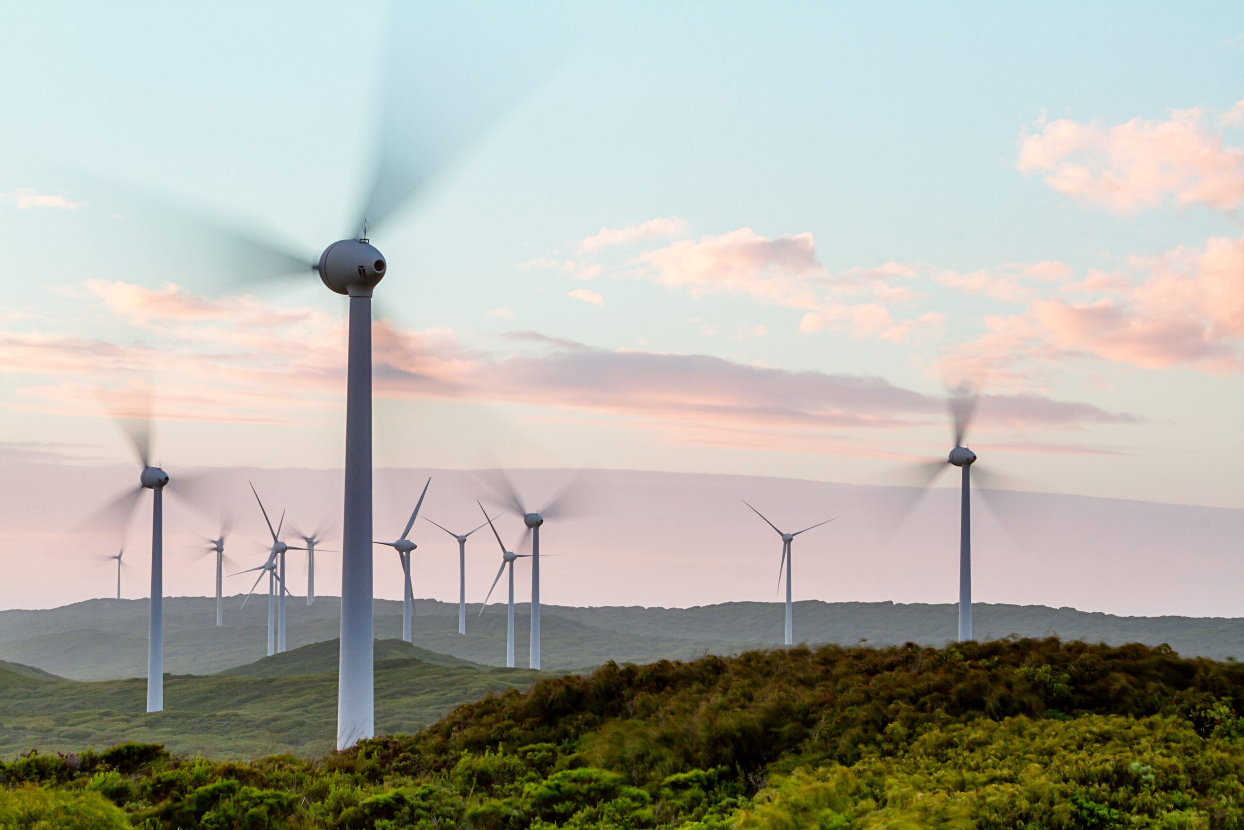
Thumbnail image source: iStock / Dobe


