Australia can be the hottest place in the world at the height of summer, but in April 2024 the country was an island of abnormally cold weather amid a sea of record-breaking global heat.
Data released this week by Berkeley Earth shows that Earth’s global average air temperature in April 2024 was 1.67 ± 0.11°C above the 1850 to 1900 average. This was the highest April average temperature on record, beating the previous record from 2020 by 0.14°C.
Last month continued a prolonged run of record-breaking global heat that has been going on uninterrupted since June 2023, with April becoming the 11th consecutive month to set a new monthly global average temperature record.
Against this backdrop of unrivalled global warmth, it was surprising to see Australia register its first cooler-than-average April in nine years.
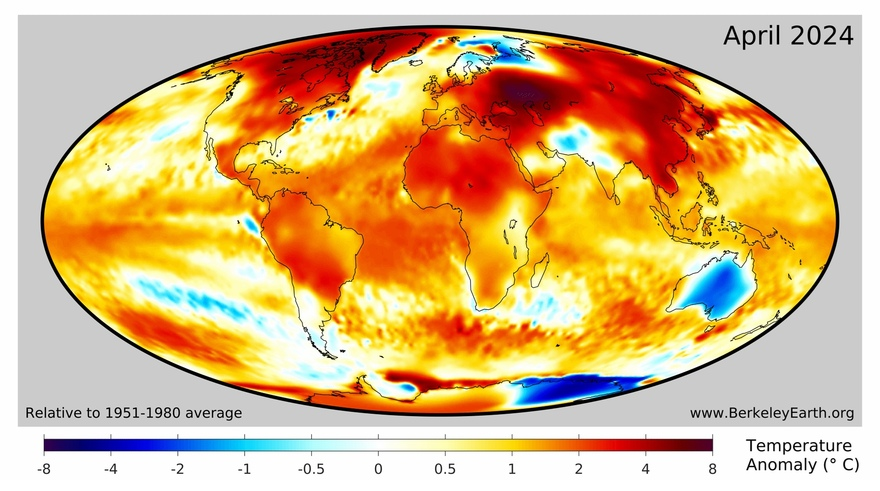
Image: Mean temperature anomaly for April 2024, according to Berkeley Earth
The blue blob over Australia on the map above shows that the mean air temperature over Australia in April 2024 was lower than the 1951-1980 average. It’s one of only a few places on Earth’s surface that were cooler than average in April 2024.
The chart below shows Australia’s April mean temperatures for every year from 1910 to 2024, relative to a slightly more recent baseline (1961-1990). The graph reveals that April 2024 was the first cooler-than-average April since 2015.
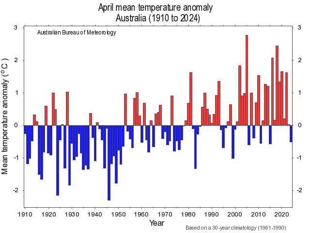
Image: April mean temperature anomaly between 1910 and 2024. Source: Bureau of Meteorology
So, what made Australia so cool in what was an otherwise record-breaking warm month for Earth’s atmosphere?
It was all about pressure. More specifically, an abnormal dominance of high pressure centred to the south of WA.
While high pressure systems are frequently found to the south of Australia in autumn, they were more persistent than usual to the south of WA last month. The monthly mean sea level pressure to the south of WA was more than 12 hPa above the long-term average in April 2024.
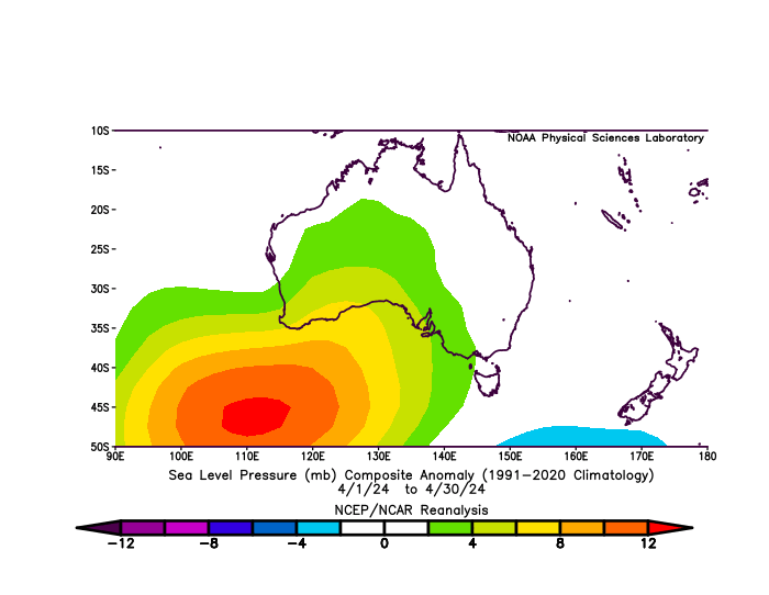
Image: Mean sea level pressure anomaly for April 2024. Source: NOAA – NCEP/NCAR Reanalysis Project
When high pressure is centred to the south of WA, it causes southerly component winds to carry cool air across Australia. When these high pressure systems are strong and large, the southerly winds can be persistent and transport cool air across the entire continent.
So, while many areas of Earth were experiencing record-breaking warmth in April 2024, Australa was one of the only places being kept cooler than normal thanks to a stagnant weather pattern. This is a good example of how periods of cold weather can mask the longer-term warming trend of climate change.
You can’t control the shifting climate, but you can gain precision insights to optimise your response.
DTN APAC, a DTN company, has been providing weather intelligence and innovative forecasting systems to Australian businesses since 1998.
We have intuitive solutions that serve industries from aviation, mining and energy right through to marine, and everything in between. Rest assured, if we don’t already have a product to address your business’ weather needs, we will work tirelessly to create one.
With our network of global partners, we provide trusted, industry-leading services that can mitigate weather risk, keep your valuable staff and assets safe, and ensure you are operating at peak efficiency. Contact us here.


