
Rain has begun falling across parts of NSW and it is here to stay for a while, with the potential for hundreds of millimetres to fall along the central NSW coastline.
The image below shows thick cloud, rain and thunderstorms stretching from northwest NSW through to the central coastline on Tuesday afternoon. A line of thunderstorms is also lingering off the Hunter coastline this afternoon.

Image: Himawari satellite image at 12:20 AEST on Tuesday, April 30.
The rain and thunderstorms are forming along a coastal trough near the Hunter and an inland trough sitting through Qld and NSW’s interior.
Rainfall could fall each day in some areas of NSW for the next 7 to 10 days, as a stubborn high-pressure system causes a prolonged period of moisture-laden easterly winds to feed into NSW. These easterly winds are particularly humid because the Tasman Sea is unusually warm causing the atmosphere above the ocean to be humid.
Rainfall is set to intensify over NSW and southern Qld later this week as this moisture interacts with an upper-level cut-off low.
There is some uncertainty about the upper-level low’s position and the resulting rainfall towards the end of the week. The map below shows one computer model’s forecast position of the upper-level low will be in western NSW on Friday evening. The blue shades over eastern NSW show excessive amounts of precipitable water or a large water content in the atmosphere which can be rained out.
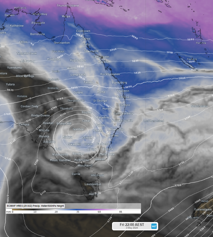
Image: 500hPa height and precipitable water at 10pm AEST on Friday, May 3, according to ECMWF
There is agreement between the forecast models that largest totals will fall across eastern NSW, but western and central NSW and southern Qld should see one or two days of decent rain.
The maps below show three different computer models forecast rainfall in the next week, with the potential for 100-150mm to fall in areas of the central and northern NSW coastline. You can also see that two models are predicting substantial rainfall to fall over western NSW, with the potential for 60-80mm to fall in parts during the next week.
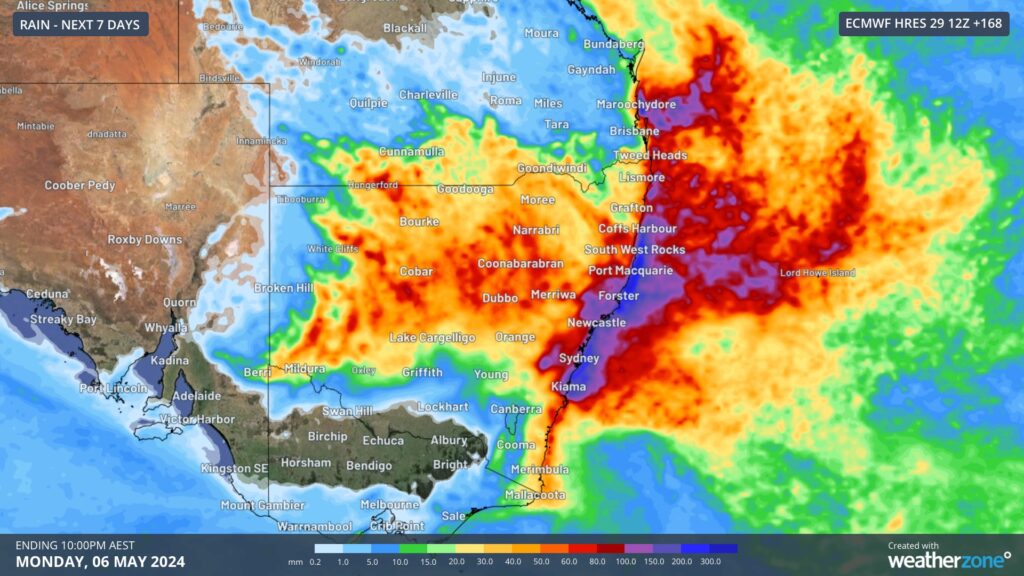
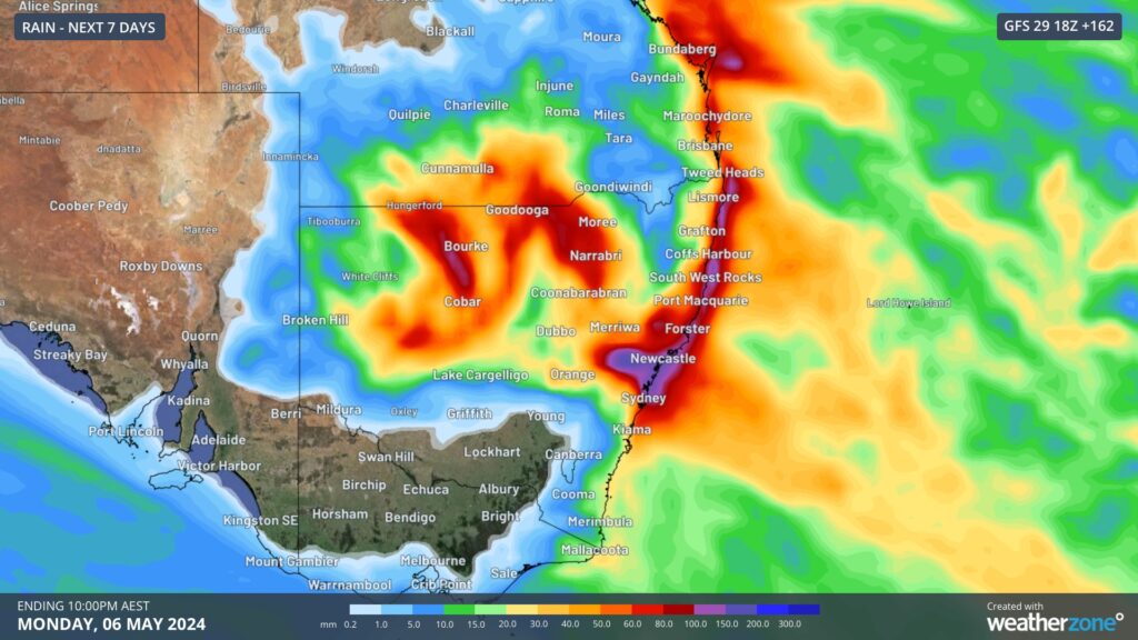
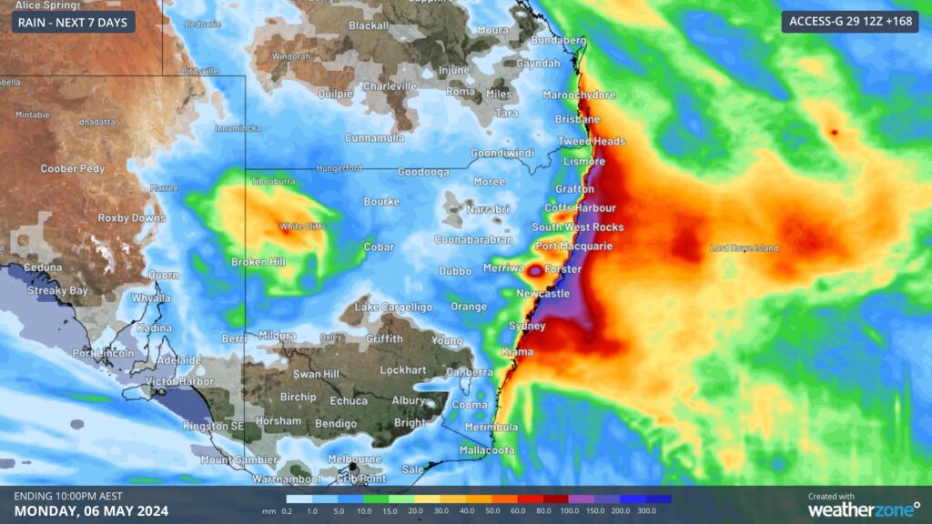
Images: Accumulated weekly rainfall forecast to 10pm on Monday, May 6, according to ECMWF (top), GFS (middle) and ACCESS (bottom).
You can see in the images above that there is still some uncertainty around where the heaviest rainfall will be along the east coast in the next 7 days. This is due to the models differing position of the surface level low which could form later this week off the NSW coast, with the heaviest rainfall expected to fall along the southern flank of the low.
Models are suggesting that the heaviest rainfall should fall over the weekend in eastern NSW. Flooding is a risk in NSW over the weekend, especially because the heavy rainfall will be falling over a sodden landscape with rainfall expected each day in the lead up to the weekend.
We will be watching this event closely as it unfolds and please keep an eye out for the latest warnings here.
Rail and transport networks are exposed to severe weather risk, every day. Our services significantly improve efficiency, safety, and planning. DTN APAC, a DTN company, specialises in building customised weather monitoring and alerting solutions. These guide transport operators to plan and respond effectively. We tailor our data and
analytics to your exact requirements. For more information, please contact us at apac.sales@dtn.com.


