Intense and disruptive thunderstorms, rain, strong winds and large surf will develop along eastern NSW later today, bringing localised areas of flooding and hazardous driving conditions.
A cut-off low currently tracking over western NSW, is bringing heavy rain and thunderstorms to the region. This burst of early spring storms already marks the wettest September day in:
- In 30 years of records for Mudgee Airport (64mm)
- In 29 years of records for Cobar Airport (53mm)
- 28 years for Cobar (33mm)
- 12 years for Dubbo (46mm) and Trangie (35mm)
- 9 years for Nullo Mountain (37mm)
Video: Combined radar and satellite imagery showing rain and thunderstorms (pink blobs) moving over NSW on Wednesday, September 10, 2025.
As the low tracks east over the Great Dividing Range into eastern NSW, it’s expected to rapidly intensify this evening, with the central pressure possibly dropping by 10 hPa in only a few hours. Winds will quickly speed up around the low, bringing a period of intense weather with strong winds, heavy rain and large surf to eastern NSW.
This rapid intensification will be fuelled by cold air in the atmosphere above the surface system and very warm sea surface temperatures (SST) sitting off the NSW coastline.
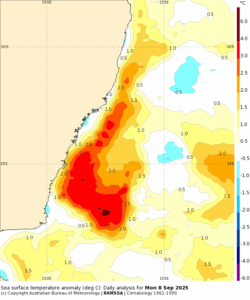
Image: SST anomalies off the NSW coastline on Monday, September 8, 2025. Source: Bureau of Meteorology
Heavy rain and localised flooding
The video below shows the low rapidly intensifying off either the Illawarra or Sydney coastline into the early hours of Thursday.
Video: Mean Sea Level Pressure (MSLP) and 6-hourly rainfall forecast over parts of NSW between now and Thursday, September 11, 2025.
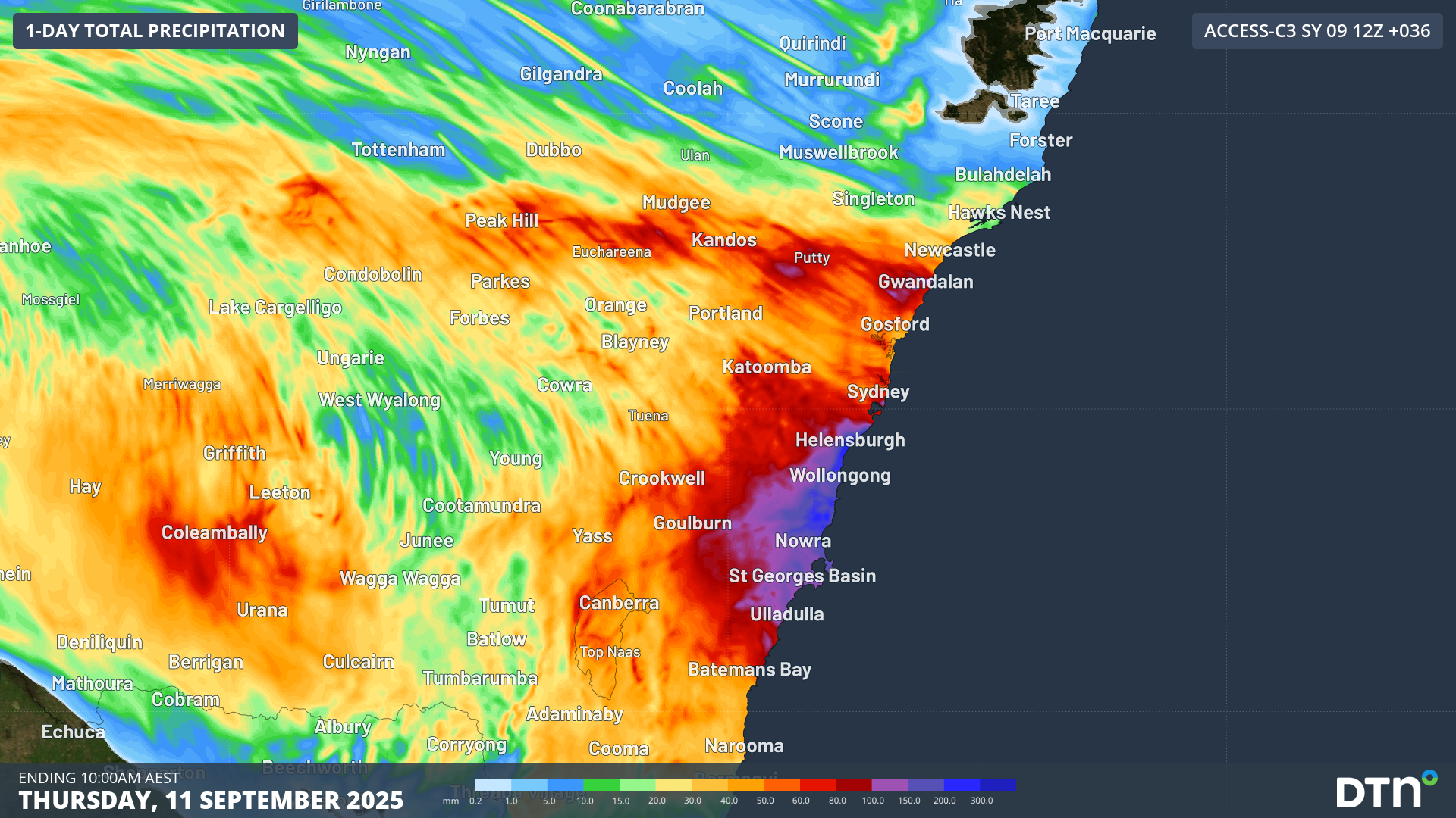
Moist easterly winds feeding around the system could bring intense heavy rainfall of 80-100mm in a few hours overnight into Thursday, most likely along coastal parts between Wollongong and Ulladulla. Rainfall accumulations across the coming 24 hours could reach close to 200mm in some areas. Heavy bursts of rainfall within short periods of time will bring the risk of localised flash flooding, possibly cutting off road transport and access to infrastructure and utilities.
Broader areas of NSW will receive rainfall accumulations of 30-60mm across Wednesday and Thursday morning, before showers become lighter and more coastal on Thursday afternoon.

Image: Rainfall accumulations across NSW in the 36-hours to 10am on Thursday, September 11, 2025.
Strong winds and large surf
While the low pressure system is only expected to be within close proximity to the NSW coastline for less than 12 hours on Thursday, its rapid intensification will bring the risk of damaging winds.
Coastal parts between Batemans Bay and Port Macquarie could experience wind gusts of 90-100km/h on Thursday morning and early afternoon, with potential for 110km/h gusts along parts of the Sydney and Hunter coastline. Wind gusts exceeding 80km/h are also possible along parts of NSW’s Northern Tablelands and southeast Queensland’s ranges.
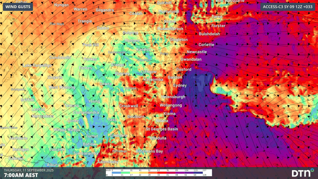
Image: Forecast 10m wind gusts at 7am AEST on Thursday, September 11, 2025.
Gusty southerly winds will persist into Thursday afternoon for coastal areas, before gradually easing as the low moves further away from NSW.
The rapid bursts of gale force winds will also whip up some large seas along parts of NSW’s coastline. Swell heights reaching 5-6 metres are expected between the Illawarra and Mid North Coast on Thursday, with maximum wave heights reaching near 10 metres at times.
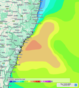
Image: OneFX forecast significant wave height at 1pm AEST on Thursday, September 11, 2025.
This intense burst of severe weather will quickly move off over the Tasman Sea with the low on Friday.
How DTN APAC Risk Communicators can help during severe weather
DTN APAC specialises in industry-leading forecast, alerting and threat analysis of severe weather across Australia and Asia, offering you expert, customised solutions when the weather turns wild.
You will have the most precise weather intelligence charting rainfall, wind speeds and potential flooding to help you make critical decisions quickly. Whether it’s adjusting key work schedules, protecting your staff or securing your site, we have the alerting capability to keep you steps ahead of the storm.
As the climate delivers increasingly severe weather events, their potential to impact your business operations grows.
Whether it’s preparing for the coming season, or rapid-response forecasting with flooding inbound, or simply ensuring your operations team is equipped to confidently make decisions ahead of severe weather, our weather Risk Communicators are here for you.
Our weather risk communicators deliver short- to long-term guidance from:
- hourly-event weather monitoring (alerting you of impending deluges, river flooding and damaging winds).
- week to month operational planning based on likely timing of increased flooding rain or periods of more settled weather for remedial works.
- seasonal long term planning based on climate drivers and the likely trends across the coming months.
We deliver clear and comprehensive weather data, personalised risk assessments and briefings to you and your team, so that your critical decisions can be made with confidence.
We are available 365 days a year, so you always have the timely guidance you require, especially when severe conditions hit.
You have our insights to rely on to see you through complex situations, minimising potential loss of profit and maximising the safety of your staff and assets.
Learn more about our large range of industry leading products and services or email us at sales.apac@dtn.com


