Extreme fire danger is expected in four states this weekend – including one area with catastrophic fire danger – as a brief burst of heat affects South Australia, Victoria, Queensland and New South Wales.
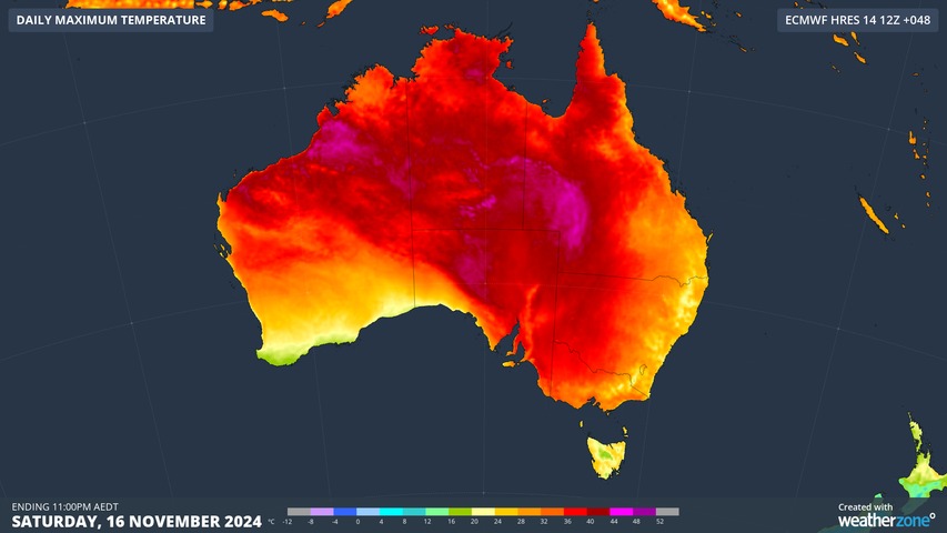
The heat will impact SA and Vic first, with temps soaring on Saturday.
- Adelaide is heading for 37°C on Saturday and Melbourne is going for 34°C.
- if those maximums are reached, they would both be the hottest days so far in spring 2024.
Meanwhile temps in northeastern SA will top 40°C, while the northwest corner of Victoria will nudge the 40-degree mark.
Even places like Warrnambool on Victoria’s southern coastline should reach 35°C on Saturday. That would be more than eight degrees above the city’s hottest temp recorded so far in spring 2024.
Gusty winds will also accompany the hot temps as northerlies strengthen ahead of an approaching cold front, and that’s why the fire danger is elevated in both SA and Victoria on Saturday.
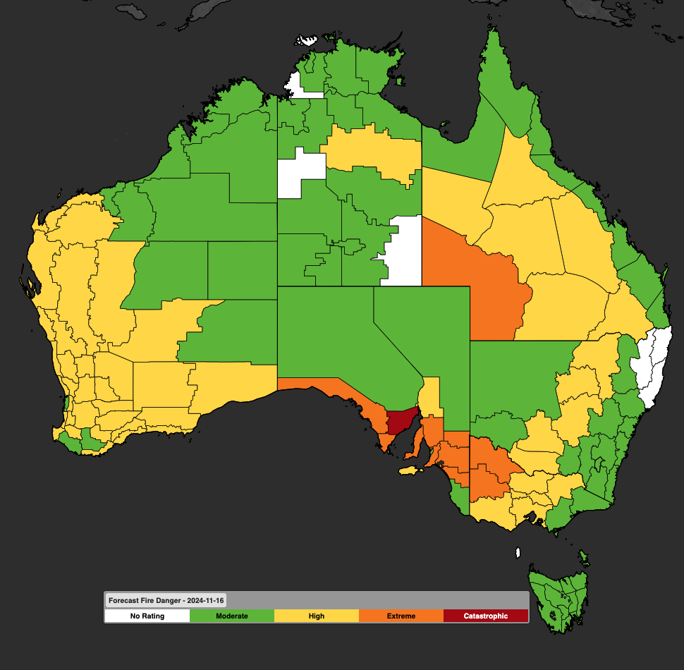
Image: Fire danger for Saturday, November 16. The map is broken into fire weather districts.
As you can see, the highest fire danger in the country for Saturday is the catastrophic rating in the Eastern Eyre Peninsula forecast district.
That reflects not just the classic hot and windy conditions which so often fuel bushfires, but the dry weather which has prevailed for virtually all of 2024 – making the landscape highly prone to burning.
As the chart below shows, severe rain deficits have been experienced this year in most of southern and eastern SA, and also in large parts of Victoria. The chart includes data from January to the end of October, and the pattern has continued into the first half of November.
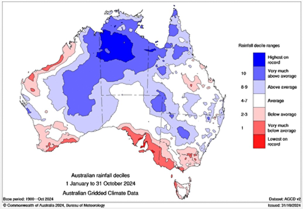
Image: Rainfall deciles in Australia, 1 January to 31 October 2024. Source: BoM.
To cite just one example of a location which is much drier than usual, let’s take the city of Whyalla (population approx. 22,000) on the eastern coastline of the Eyre Peninsula – in the region where the fire danger is rated catastrophic on Saturday.
Whyalla has a fairly arid climate at the best of times, but to date this year, it has received just 118mm of rain, which is less than half what would be expected to his point.
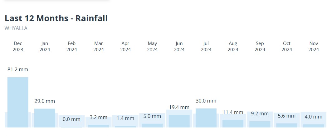
Image: The rain graph thus far for Whyalla in 2024 makes for pretty grim viewing.
The good news for residents of Adelaide and other places that will cop Saturday’s hot blast is that a cool change is coming. It should arrive in Adelaide in the later afternoon, with temps dropping from the high 30s down towards 20°C by 7pm.
The not-so-great news is that the cool change won’t have much rain coming along for the ride, with only a few millimetres at best expected for Adelaide into Sunday.
The heat spreads east on Sunday and this is reflected in Sunday’s fire map, with a few orange areas of extreme danger spreading into NSW.
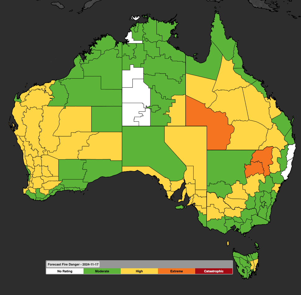
Image: Fire danger for Sunday, November 17. The map is broken into fire weather districts.
Working in often severe conditions in the high-risk fields of forestry and emergency, our consolidated weather services can ensure full situational awareness for you and your team.
DTN APAC serves the forestry and emergency sectors, delivering trusted weather data and severe weather alerting to maintain safety, protect your assets and underpin your planning.
Weatherzone’s trusted nowcasting and forecasting system, OpticastTM, is independently proven to outperform other industry models, allowing you to respond rapidly to changing conditions. Opticast can ingest data from your on-site weather observation equipment, ensuring your forecast is customised to your local microclimate. From nowcasting and 14 day forecasting to seasonal outlooks, you have powerful, hyper-local weather alerting and intelligence, giving you decisive confidence when it’s most needed.
With lightning a prominent cause of forest fires throughout Australia, Weatherzone’s Total Lightning Network offers real-time detection and unsurpassed accuracy of lightning strikes to <200m. Based on a vast sensor network, both intra-cloud and cloud-to-ground strikes are located, ensuring you are alerted when severe weather is building and threatening your teams, assets and infrastructure. When volatile conditions increase the ferocity of fire it’s imperative you have lead-time to enact safety plans, keeping your people out of harm’s way.
Your weather intelligence is accessible across all devices in your network via our Weatherguard App, and your customisable interface.
We are there for you when you need us the most – 24/7, 365 days a year. For more information please visit our website or email us at sales.apac@dtn.com.


