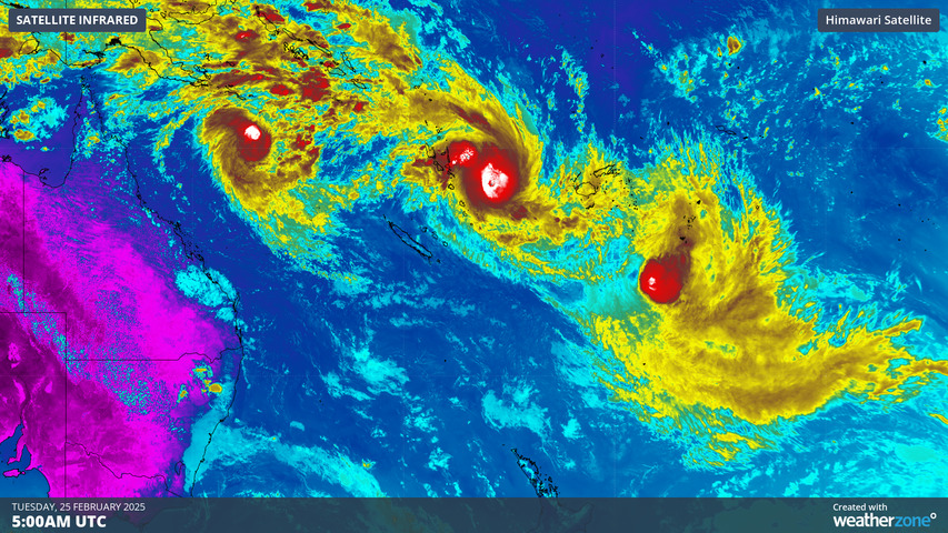
Satellites have captured a rare sight of three tropical cyclones spinning simultaneously over the South Pacific Ocean this week, with several Pacific islands facing heavy rainfall this week.
The images below show three separate tropical cyclones spiralling over the South Pacific on Tuesday, creating a vast band of clouds stretching around 5000km in length.
Video: True-colour satellite images showing three tropical cyclones over the South Pacific on Tuesday, February 25, 2025.
Going from left to right, the animation above shows Tropical Cyclone Alfred over the northern Coral Sea, Tropical Cyclone Seru near Vanuatu and Tropical Cyclone Rae to the southeast of Fiji.
Thankfully, none of these tropical cyclones are expected to directly impact populated landmasses during the next few days. However, the broad mass of cloud associated with these three tropical systems will cause rain and thunderstorms over some South Pacific islands in the coming week.
The image below shows one model is forecasting widespread falls of 100 to 150mm, with isolated totals of 200 to 250mm possible across northern Vanuatu, northeastern New Caledonia and the southern Solomon Islands.

Image: Accumulated precipitation to 5am AEDT on Thursday, March 6, according to Access G.
These three systems are making up for what has been an otherwise quiet tropical cyclone season to date in the South Pacific.
One way that meteorologists measure seasonal tropical cyclone activity is by using the accumulated cyclone energy (ACE) index. The ACE is a measure of the overall activity of tropical cyclones in a given period and region. It is calculated from the 6-hourly maximum wind speeds all tropical cyclones that reach category one strength of above on the Australian scale.
As of last Friday, the total ACE in the South Pacific so far this season (since July 1) was only about 4.0, which was well below the long-term average of 40.5 for this time of year. This shows that the South Pacific had seen barely any tropical cyclone activity so far this season.
However, this week’s trio of tropical cyclones has already pushed the South Pacific ACE up to 15.2 as of Tuesday, February 25, and it will continue to climb in the coming days.
The surge of tropical rainfall will also help make up for a relatively dry season to date in the South Pacific. The map below shows the observed rainfall anomaly from the past four months in the Pacific Ocean region, with large areas of lower-than-average rainfall in the South Pacific.
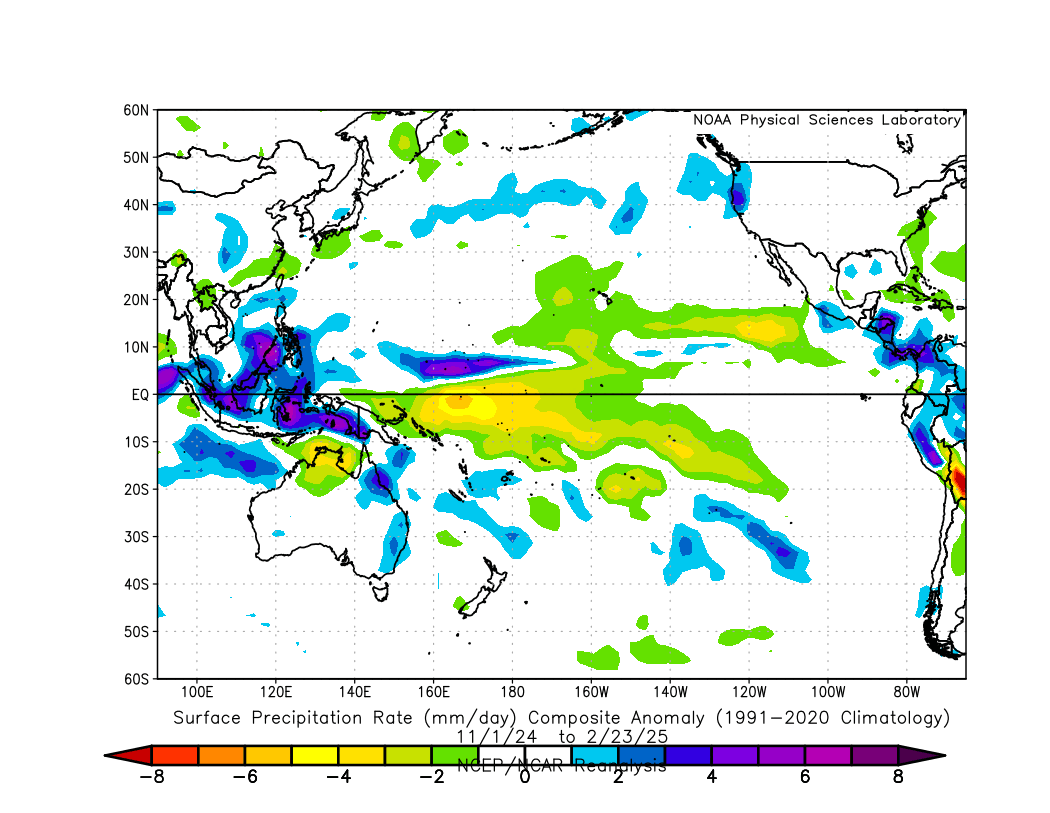
Image: Precipitation anomaly for the period from November 1, 2024 to February 23, 2025. The baseline used for this anomaly was 1991-2020. Source: NOAA
While Alfred, Seru and Rae aren’t expected to directly impact populated landmasses in the coming days, meteorologists will also be keeping a close eye on Tropical Cyclone Alfred in the Coral Sea.
How DTN can help
- Helps businesses plan ahead and reduce the impact on operations
- Provides real-time situational awareness
- Helps businesses maintain flood risk awareness
- Improves communications with local information and flood alerts
- Provides team-wide access to flood risk data
We will support you, 24/7, keeping you informed and making your critical decisions easier. For more information, contact us at sales.apac@dtn.com


