
Rain, and plenty of it, is forecast to drench areas south and west of Sydney on Thursday, with isolated accumulations of up to 250 mm possible within 24 hours in some spots.
Weatherzone meteorologist Ashleigh Madden wrote on Tuesday about the eastward-moving upper level low pressure system that could deliver a deluge to parts of NSW as a surface low develops. That forecast appears to be on track.
Just after 2 pm on Wednesday, the BoM issued a severe weather warning for people in Illawarra district just south of Sydney, as well as parts of the South Coast, Central Tablelands and Southern Tablelands forecast districts.
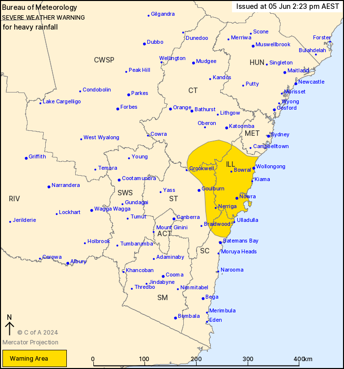
Image: The areas likely to see the heaviest rain are in the yellow zone. Source: BoM.
The BoM says a surface trough extending from the Illawarra region into the Tasman Sea will deepen during Thursday in response to the upper low over New South Wales.
A strengthening humid southeasterly flow to the south of this trough will inject moisture, bringing all the elements together for a burst of persistent heavy rain in the areas just mentioned. That rain will likely persist into Friday morning.
The BoM says that rain will be heaviest in the warning area during Thursday morning, spreading north in the afternoon and evening. In terms of totals, it says that:
- Six-hourly rainfall totals between 50 and 90 mm are likely
- Isolated totals of 120 mm are possible on the windward ranges.
- 24-hourly rainfall totals between 100 and 150 mm are likely in some areas and as mentioned, there could even be isolated totals of 250 mm.
While conditions are expected to ease during Friday morning as the trough moves south, this system is still developing so please check the Weatherzone warnings page for live updates if you live in one of the affected areas or if you are on the roads.

Image: Things could get a little sketchy along the Sea Cliff Bridge, just north of Wollongong, so please slow down on the roads. Source: iStock.
And remember that with a rainfall event of this intensity, flash flooding is highly likely. The Illawarra district in particular is known for flash flooding as the city of Wollongong and many nearby areas occupy a narrow strip of land beneath a steep coastal escarpment – leading to huge run-off during these events.
Are you protecting your enterprise from increasingly volatile weather risk?
You can’t control the shifting climate, but you can gain precision insights to optimise your response.
DTN APAC, a DTN company, has been providing weather intelligence and innovative forecasting systems to Australian businesses since 1998.
We have intuitive solutions that serve industries from aviation, mining and energy right through to marine, and everything in between. Rest assured, if we don’t already have a product to address your business’ weather needs, we will work tirelessly to create one.
With our network of global partners, we provide trusted, industry-leading services that can mitigate weather risk, keep your valuable staff and assets safe, and ensure you are operating at peak efficiency. For more information please contact us at apac.sales@dtn.com.


