Rain will drench a large area of central, southern and eastern Australia this week as an unusual weather pattern causes Coral Sea moisture to clash with a cut-off low directly above Australia.
A large high pressure system will deepen to the south of Australia later this week, causing a pool of cold upper-level air to become isolated over the Great Australian Bight.
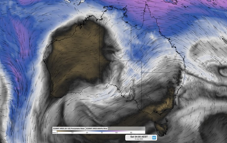
The strong high pressure system will also allow a long fetch of east to northeasterly winds to carry moisture-laden air from the Coral Sea towards southern Australia in the second half of this week.
The combination of this cut-off low over southern Australia and the injection of tropical moisture will cause widespread cloud and rain over multiple Australian states, starting this Thursday and possibly continuing into early next week.

Image: Modelled precipitable water and 850hPa wind, showing northeasterly wind carrying moisture-laden air from Australia’s northeast tropics towards South Australia.
A broad band of cloud and rain should develop from Qld to SA from Thursday and persist into the weekend. Rain will then become more widespread and heavier over parts of central, southern and eastern Australia from Sunday into the first half of next week, as the upper low moves further east.
The map below shows how much rain one computer model is predicting between now and Tuesday next week.
Image: Forecast accumulated rain during the nine days ending at 10pm AEST on Tuesday, July 9, 2024.
Parts of Qld, SA and NSW could see 30 to 60 mm of rain from this system over the space of several days. This includes parts of the Lake Eyre and Murray-Darling Basins.
While this rain will help fill inland water storages, it may also be heavy enough to impact outback road and rail transport networks. Flood watches and severe weather warnings will be issued later this week and early next week if necessary.
One interesting aspect about the band of rain-bearing cloud that is predicted to develop this week is that it will extend over Australia from northeast to southwest. This orientation is unusual because it mirrors the more typical northwest cloudbands that develop over Australia when Indian Ocean moisture flows over Australia from the northwest. It’s rare to see a ‘northeast cloudband’ over Australia.
Rail and transport networks are exposed to severe weather risk, every day. Our services significantly improve efficiency, safety, and planning. DTN APAC, a DTN company, specialises in building customised weather monitoring and alerting solutions. These guide transport operators to plan and respond effectively. We tailor our data and
analytics to your exact requirements. To find out more, please contact us at apac.sales@dtn.com.


