Thick fog affected operations at Melbourne Airport on Monday morning, causing delays at the busy airport
All the ingredients for a thick fog were in place overnight across a broad area of central and western Victoria as well as the southeastern corner of SA, including:
- Calm winds
- Cool temperatures with temps dropping to the dew point
- A moist atmosphere
- High pressure with a stable inversion layer
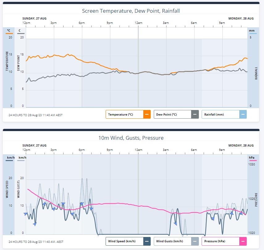
The two graphs below show how atmospheric conditions aligned perfectly for fog to form.
- The first graph shows how the temperature reached the dew point just before 11 pm
- The second shows how the wind died down to completely calm conditions a little earlier in the evening
You can see the dense fog that was still sticking around on the 9 am satellite image below.
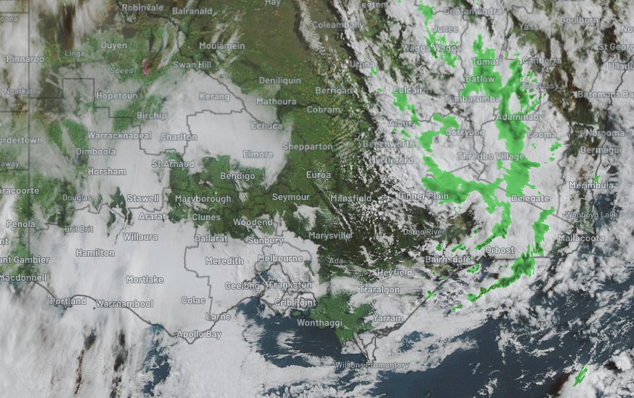
That large arc of thick cloud extending from the Melbourne area out to the SA border and up around to the Murray near Echuca is all fog, not cloud. In some areas, visibility was down to just 100 metres.
READ MORE: What’s the difference between fog and ground-level cloud?
One clue that the cloud in that satellite image is fog, not cloud, is the lack of any nearby radar activity.
The green blobs indicate precipitation, not just heavy cloud cover, and you can see rain (which is actually snow at high elevations in the NSW Snowy Mountains) falling to the east of the area mentioned, but none within it.

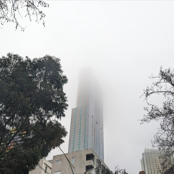
Image: Melbourne on the morning of Monday, August 28. Source: @Calendal on Instagram.
Meanwhile the fog started to clear as the morning progressed and the sun began to “burn it off”. But it has taken a while and there were disruptions to air traffic at Melbourne Airport.
Fog is affecting operations at Melbourne Airport this morning. Arrivals and departures may be delayed. For flight details please check with your airline. Find out more about how we deal with fog here: https://t.co/iPw0CAXOuS
— Melbourne Airport (@Melair) August 27, 2023
As often happens after foggy mornings, the day has started to warm quite quickly once the sun breaks through, with Melbourne tracking for a top temp of 18°C after an overnight low of 9.5°C.
Tuesday will be warmer again with a top around 20°C whole Wednesday should see a high of just 15°C as a cold front sweeps over southern Victoria. Gusty winds ahead of the front and after it will make it highly unlikely that we see a repeat of Monday morning’s fog in coming days.
How does fog affect airport operations?
When the visibility at the airport drops due to thick fog, aircrafts movements are reduced to ensure safety. This greatly reduces the number of aircraft that can take off and land, which can lead to delays across the network.
How can Weatherzone help?
DTN APAC delivers a proven aviation weather briefing system, developed in collaboration with the industry, to keep your enterprise performing at peak efficiency.
We meticulously tailor actionable weather intelligence to suit the scope of your company’s work, on the ground and in the air. Accurate and comprehensive international data informs your daily decisions on safety, fuel loads and staffing.
Working alongside our global network of partners and suppliers we collate the data to give you full situational awareness of both en route and port specific conditions. Weatherzone is accredited and adheres to standards for aviation meteorology set by the World Meteorological Organisation (WMO) and the International Civil Aviation Organisation (ICAO). Registered with the ICAO and providing safety critical OPTMET data with permission from Air Services Australia, our aviation services meet the industry’s stringent requirements.
This is weather intelligence delivered in an easy to visualise format. No matter what the weather has in store, we give you clear foresight to make informed decisions. For more information, please contact us at apac.sales@dtn.com


