

Heavy and remarkably widespread rain has fallen across New South Wales and southern Queensland overnight, with the heaviest falls centred on the Sydney region.
- The Sydney CBD copped an absolute drenching, with 111 mm in the gauge in the 24 hours to 9 am. That wasn’t too far off the daily record of 191 mm for April, set way back in 1860, and inlcuded 57.2 mm in just one hour of paticularly intense rainfall up to 3:35 am.
- Penrith in the city’s outer west also got close to triple figures overnight, with 84.8 mm.
But as mentioned, it was the widespread nature of the overnight rain that was remarkable, especially from a New South Wales perspective. NSW is broken into 17 forecast districts (or 16 plus the ACT) and each one of those saw rain overnight.
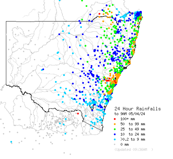
Image: 24-hour rain totals in NSW to Friday, April 5. Source: BoM.
While rain was heaviest in the eastern half of the state with numerous falls exceeding 50 mm in coastal districts north of Sydney, this ongoing event is by no means just a coastal system. Some of the noteworthy inland falls in the 24 hours to 9 am Friday included:
- 37.2 mm at Dubbo in the Central West Slopes and Plains forecast district
- 30.8 mm at Tamworth in the North West Slopes and Plains forecast district
- 70.4 mm at Mount Boyce in the Central Tablelands
- 66.4 mm at Goondiwindi in the Darling Downs and Granite belt forecast district of Qld (to 8am)
The widespread rain has been caused by an upper-level low pressure system with an associated series of troughs and an easterly moisture feed from the unusually warm water of the Tasman Sea – and it is far from done.
As Weatherzone meteorologist Ben Domensino wrote yesterday, the most intense period of rain and wind during the next three days will occur over the central and southern coast and ranges in NSW between Friday afternoon and Saturday afternoon.
At 7:30 am Friday, the BoM issued a Severe Weather Warning for heavy, locally intense rainfall and damaging winds for the Metropolitan, Illawarra, South Coast, Southern Tablelands and parts of Hunter, Central Tablelands, Snowy Mountains and Australian Capital Territory Forecast Districts.
The Bureau warned that those areas could expect “widespread heavy to locally intense rainfall and damaging wind gusts expected about central parts of the coast and ranges today, moving south on Saturday”.
Meanwhile flooding is always a risk in these types of events, and this sort of system has the potential to deliver both flash flooding and riverine flooding.
- Flash flooding occurs within six hours of a heavy downpour or burst of rain and tends to occur in a localised area.
- Riverine flooding is when rivers break their banks and tends to occur after sustained heavy rainfall either in the affected area or upstream, or both.
Please check the Weatherzone warnings page for the latest. With this system well underway, there are already numerous flood warnings, hazardous surf warnings, and strong wind or gale warnings in place.
DTN APAC, a DTN company, specialises in building customised weather monitoring and alerting solutions. These guide transport operators to plan and respond effectively. We tailor our data and analytics to your exact requirements. We support you whilst conducting a thorough
assessment of your weather and environmental monitoring as well as forecasting requirements. This identifies how weather impacts your network and where improvements can be made. You can then choose tailored solutions to boost your operational efficiency and profitability.
Safeguard your people and sites
Aquire Total Lightning Network – precise lightning detection and SMS alerting to pinpoint where your personnel need to prepare and respond.
Improve your uptime
Limit unnecessary downtime and schedule maintenance in optimal weather windows. Enhanced real-time situational awareness guides the coordination of your team and operations.
Drive confident decision-making
You will have the expert insights you need to make critical decisions quickly and confidently, reducing costly and disruptive delays.
For more information on our services, please contact us at apac.sales@dtn.com.




