
One of the strongest cold fronts of 2024 will sweep across southeastern Australia during the next two days, causing damaging winds in parts of Tas, SA, Vic, NSW and WA. Some places are even likely to see destructive wind gusts from this powerful and dangerous weather system.
A very steep pressure gradient is becoming established to the south of Australia this week as a colossal low pressure system near the fringes of Antarctica pushes against a ridge of high pressure above Australia.
The large multi-centred low pressure complex between Antarctica and Australia is currently deepening and could have central pressure of around 930 hPa later Tuesday into Wednesday. This is equivalent to a category four or five tropical cyclone on the Australian scale.
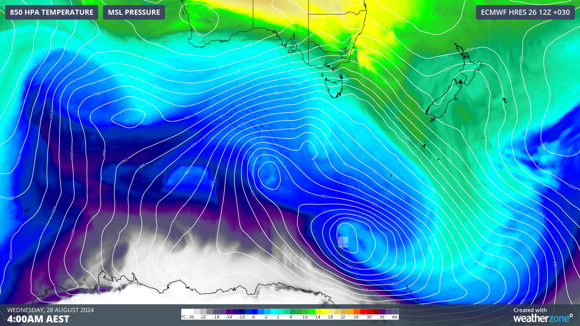
Image: Modelled mean sea level pressure and 850 hPa temperature at 4am AEST on Wednesday, August 28, showing a large and deep low pressure system located between Australia and Antarctica.
Meanwhile, a ridge of high pressure extending across Australia will maintain mean sea level pressure values of around 1020 hPa during the next few days.
These two contrasting regions of mean sea level pressure will create a steep pressure gradient of about 90 hPa over roughly 3000 km, resulting in a large region of extremely powerful winds.
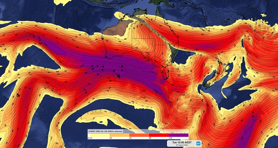
Computer models suggest that wind speeds in the jet stream, which sits about 9 to 10 km above the surface, will reach 300 to 400 km/h to the south of Australia on Tuesday.
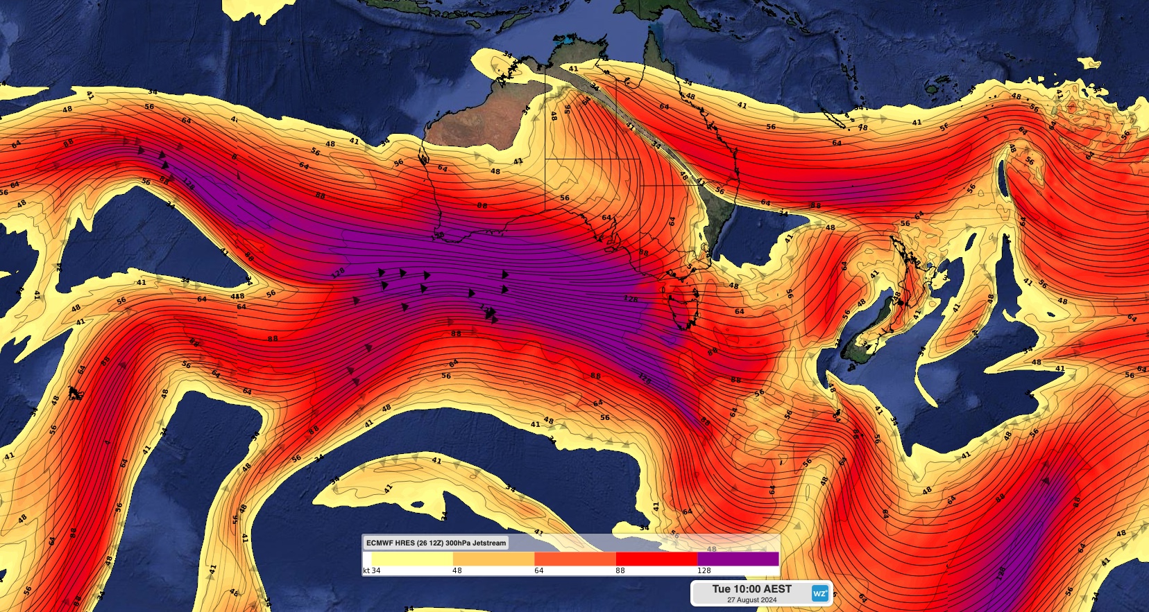
Image: Modelled 300 hPa winds showing a very strong jet stream to the south of Australia on Tuesday morning.
While wind won’t be anywhere near this strong closer to the ground, average surface wind speeds of 70 to 100 km/h are likely over the ocean to the south of Australia on Tuesday and Wednesday. This powerful surge of wind will impact some southern parts of Australia during the next 48 hours.
Severe weather warnings for damaging winds have been issued in parts of WA, SA, Tas, Vic and NSW, where damaging or destructive wind gusts are likely to occur on Tuesday or Wednesday.
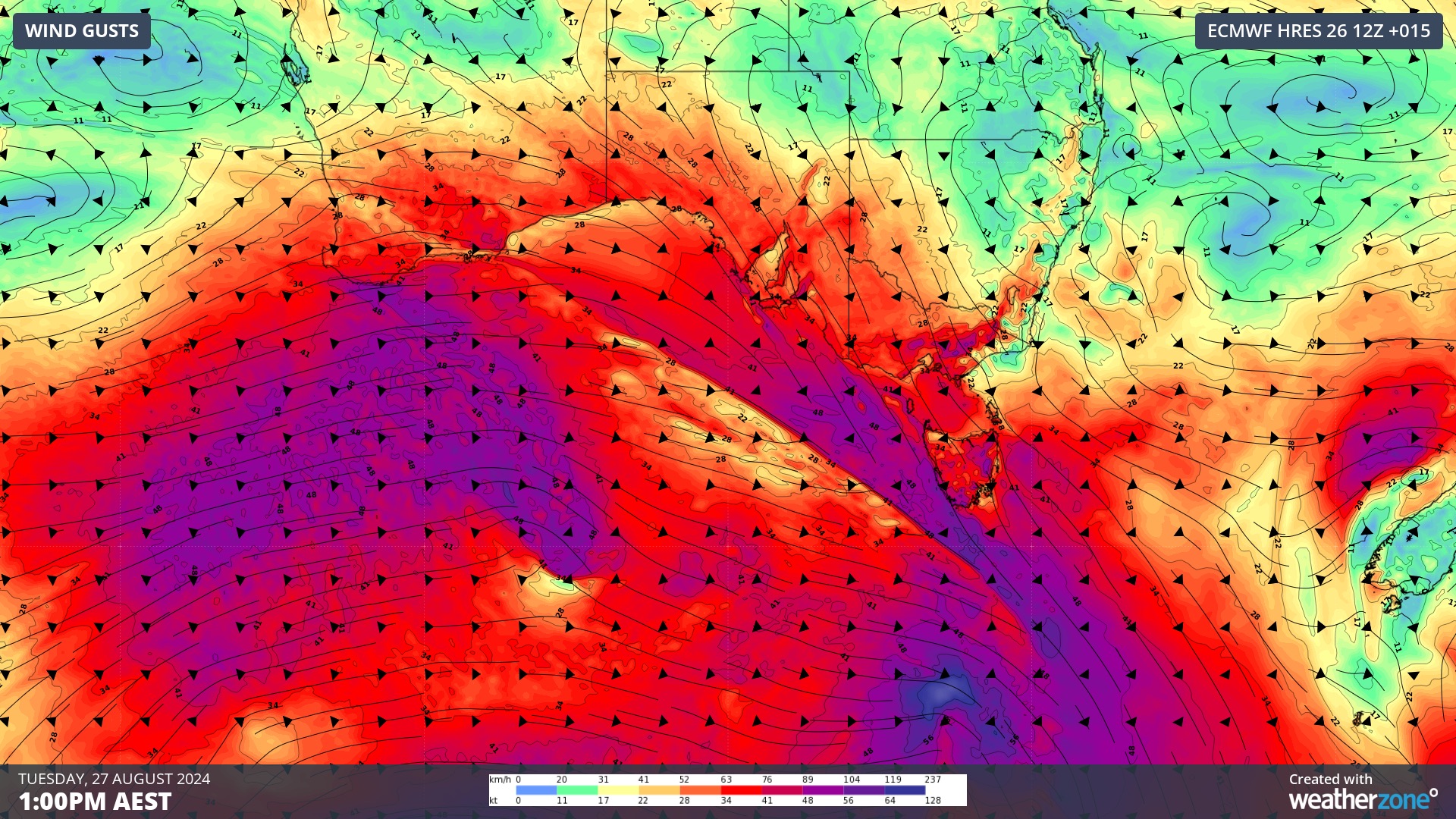
Image: Forecast wind gusts at 1pm AEST on Tuesday, August 27.
Western Australia: In WA, damaging winds with gusts reaching around 90 km/h could affect coastal areas between about Cape Leeuwin and Bremer Bay on Tuesday.
South Australia: Damaging wind gusts could develop over the state’s south and southeast on Tuesday and Wednesday. A severe weather warning has been issued for damaging winds in the Mount Lofty Ranges, Lower Eyre Peninsula, Kangaroo Island, Lower South East districts, and parts of the Adelaide Metropolitan, Yorke Peninsula, Murraylands and Upper South East districts.
Tasmania: Tasmania will be Australia’s hardest hit state from this system and a severe weather warning for damaging to destructive winds has been issued for the entire state. The strongest winds will occur in western, southern and eastern Tas, where gusts are expected to reach up to about 110 km/h in low-lying areas and above 125 km/h about elevated terrain and along parts of the state’s east coast. As of 11 am AEST on Tuesday, wind gusts had already reached 128 km/h at kunanyi / Mount Wellington and Scotts Peak.
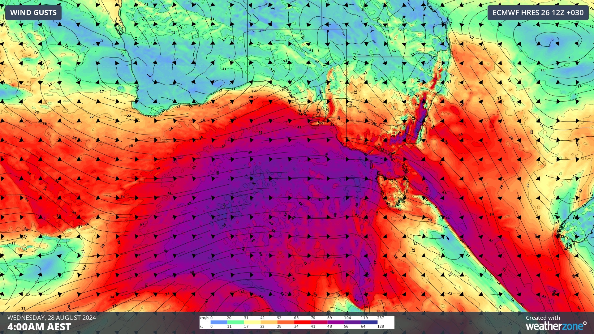
Image: Forecast wind gusts at 4am AEST on Wednesday, August 28.
Victoria: All of Vic will experience blustery winds in the next couple of days, although the greatest risk of damaging winds will be in elevated and coastal parts of the state. A severe weather warning has been issued for damaging winds in the Central, East Gippsland, West and South Gippsland districts, and parts of the South West, North Central, North East and Wimmera Forecast districts. The warning also mentions the risk of destructive wind gusts above 1000 m elevation in eastern Vic on Tuesday night.
New South Wales: Wind will increase over southern and central parts of the state from Tuesday night and on Wednesday. Damaging winds are likely to develop in southeast NSW from Tuesday night and spread into central NSW from Wednesday morning. A severe weather warning has been issued for damaging gusts along parts of the ranges and coast in southern and central NSW, including the Illawarra, Blue Mountains and far Western Sydney.
This system will cause dangerous and potentially life-threatening weather in multiple states over the next two days. Check the latest severe weather warnings in your state for the most up-to-date information.
We work with you to understand your intrinsic operational challenges and customise high-precision forecasting, metocean and aviation services to your exact location and operational scope.
When working offshore, our solutions can underpin planning and safe execution for offshore oil and gas enterprises and wind farms. Our data can support your exploration, development, rig moving, shuttle tanker operations, and production and decommissioning phases. Whether your crews are on-site, being transported to shore, or diving to perform maintenance, we deliver tailored weather risk briefings to ensure you choose the optimal time to proceed.
Weatherzone’s trusted nowcasting and forecasting system, OpticastTM, allows you to rapidly respond to changing conditions offshore, en route and in port. We take your port topography and berth orientation into account, ensuring site-specific forecasts. For offshore oil & gas, wind farms, ports and logistics, we have your weather situational awareness covered, no matter where you are. We deliver real-time severe weather and lightning alerts to your team via your integrated dashboard: Portzone, and our Weatherguard app.
Weatherzone’s Total Lightning Network (TLN) ensures you avoid hours of unnecessary downtime by providing the most accurate technology in lightning detection and alerting. Safeguard your teams and assets with lighting and Dangerous Thunderstorm Alerts (DTAs), customised to your existing parameters and delivered in real-time across all devices in your network. You gain full spatial awareness of developing severe weather systems, allowing you to plan ahead and, where needed, execute your shutdown and evacuation procedures.
With extreme conditions slowing production and affecting infrastructure, safety and transport, trust us to deliver Australia’s most precise weather data and tailored insight, giving you decisive confidence when it’s most needed. To find out more visit our contact page or email us at apac.sales@dtn.com.




