Intense and out-of-season thunderstorms, followed by a nearby volcanic eruption led to significant flight delays, diversions and cancellations at Bali’s International Airport this past Sunday and Monday.
The satellite loop below shows thick thunderstorm clouds across the Indonesian islands of Lombok, Bali and Java on Sunday.
Video: Enhanced infrared satellite imagery showing intense thunderstorm activity across Bali and surrounding areas on the evening of Sunday, July 6, 2025.
A number of flights coming in and out of Bali’s Denpasar Ngurah Rai International Airport between about 4:30pm and 10pm local time were delayed or diverted to nearby islands due to the intense thunderstorms. Low visibility in heavy downpours and the risk of lightning strikes hitting planes and operators on the tarmac make it unsafe for landing and taking off during thunderstorms.
Operating costs of a Boeing 737 or an Airbus 320 or 330, which are typically used for international flights in and out of Denpasar, range from $5,000 to $10,000 per hour. In-flight delays and additional fuel requirements needed in cases like Sunday end up costing aviation operators tens of thousands of dollars.
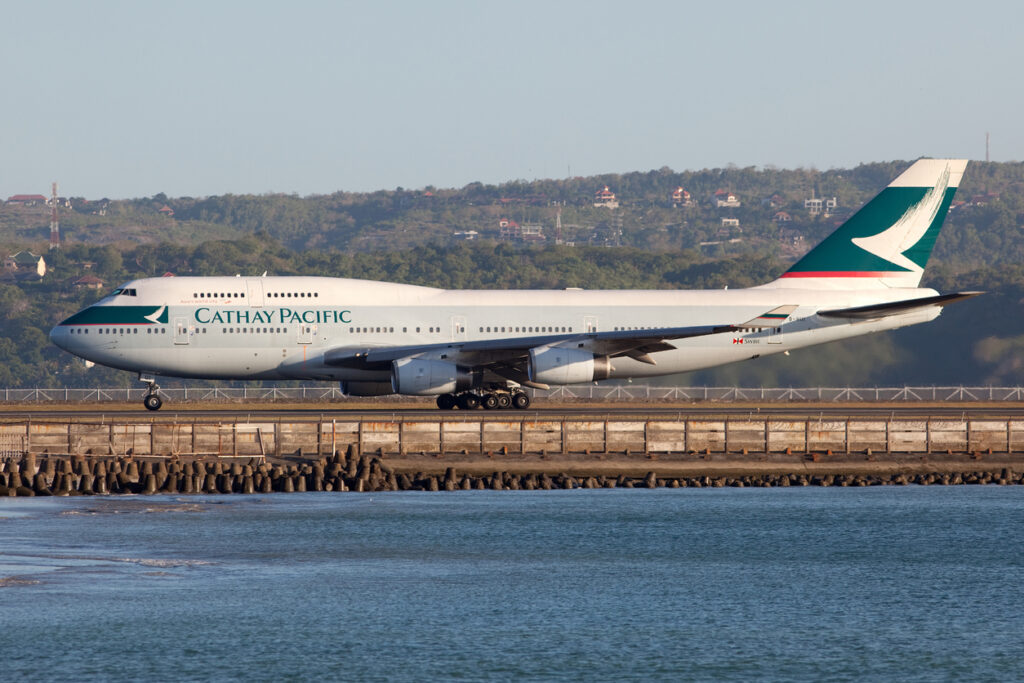
Image: A now retired Cathay Pacific Boeing 747-400 “Jumbo Jet” at Denpasar in 2009, an aircraft type that has double the operating cost of the current twin-engine planes used to service the Island of Gods. Source: iStock / Fabian Gysel
Intense tropical rainfall as seen this weekend across the region was partly due to an equatorial Rossby Wave. July is in the middle of the dry season, which typically sees less frequent rain and thunderstorms under a pattern of more predictable trade wind conditions. Tropical waves can however disrupt this pattern, bringing weather more typical to the lush wet season that runs between November and March.
What is an Equatorial Rossby Wave?
Equatorial Rossby waves travel through the tropical atmosphere from east to west, typically producing an alternating sequence of high and low pressure systems on either side of the equator. This brings mirrored zones of cloudiness and clear weather in the tropics of both hemispheres.
The map below shows the modelled influence of the equatorial Rossby wave, with areas of enhanced and suppressed convection (rain and cloudiness) north and south of the equator near Indonesia.
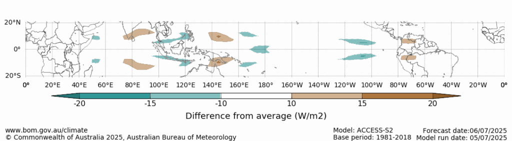
Image: Forecast outgoing long-wave radiation anomalies for July 6, 2025, associated with the equatorial Rossby wave. The green areas show where cloud cover is expected to be enhanced, while the brown shading represents suppressed cloud cover. Source: BoM.
The westwards moving Equatorial Rossby wave may still bring showers and thunderstorms on Monday across parts of Bali. Heavier falls and thunderstorms are possible this week across parts of Java, including Jakarta, as the wave progresses west.
DTN Total Lightning Network
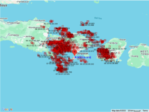
Image: Lighting strikes reported by DTN’s Total Lightning Network (TLN) within 150km of Denpasar International Airport.
The DTN Total Lightning Network is the intelligent lightning solution that goes above and beyond to alert lightning and increase your lead time before the storm hits.
We utilise a vast global sensor network, created with our partner Earth Networks. Over 1200 sensors in 40+ countries provide a worldwide view of both intra-cloud (IC) and cloud-to-ground (CG) lightning strikes, enabling businesses to plan and respond with the most precise insight available.
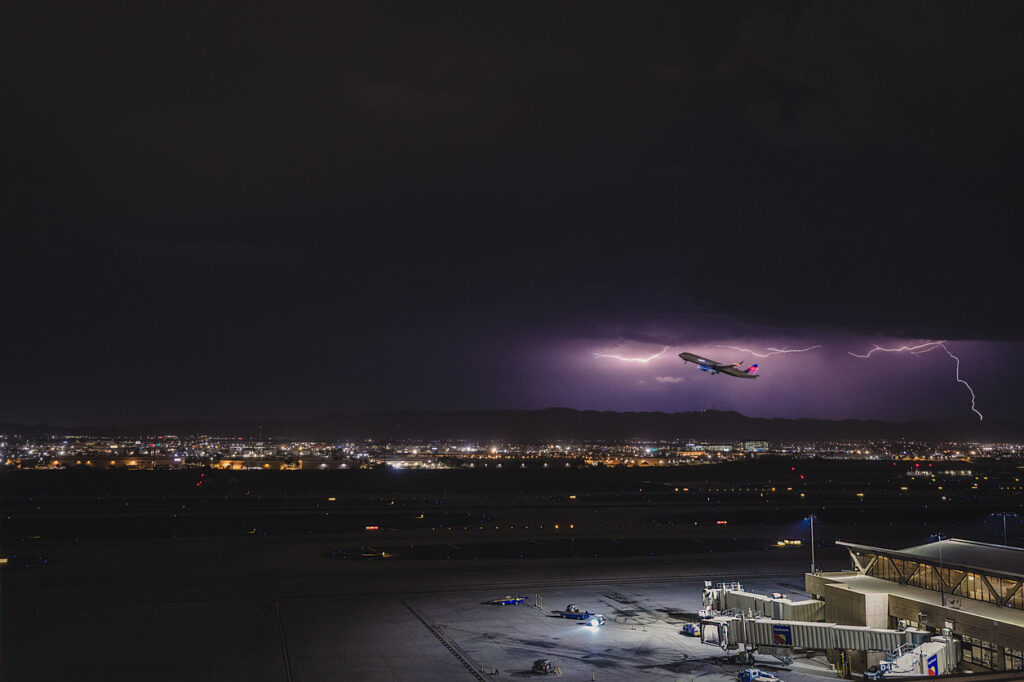
Image: The DTN TLN gives you maximum lead-time ahead of lightning, allowing you to maximise efficiency and safety around thunderstorms. Source: iStock / Matthew Perkins
Offering unsurpassed accuracy, with real-time sensing to <200m, we integrate with your existing systems to keep your enterprise operating within your defined severe weather thresholds and real-time lightning mapping for a comprehensive view of storm activity. Our technology also helps monitor radiation from electrical discharges and ensures every lightning flash is accounted for.
Lewotobi Laki-Laki volcano erupts again
Just before 11am local time on Monday, the Lewotobi Laki-Laki volcano erupted on the island of Flores, Indonesia, sending a plume of volcanic ash and gases high into the atmosphere.
Image: Volcanic ash plume visible on satellite imagery on Monday, July 7, 2025.
Laki-Laki is one of the two twin Lewotobi volcanos, located approximately 800 kilometres east of Bali, Indonesia, and 1,000 kilometres northwest of Darwin, Australia.
#BREAKING Volcanic Eruption: Lewotobi Laki-Laki
Click on video and sound up 🔊
On July 7, 2025, at 11:05 AM (Indonesia time), the Lewotobi Laki-Laki volcano, located in Southeast Nusa Tenggara, erupted.
The eruption produced an ash column reaching 18,000 meters above the… pic.twitter.com/vyym7I0rO1
— Volcaholic 🌋 (@volcaholic1) July 7, 2025
The ash plume expelled by the volcano can be estimated reaching over 15 kilometres high using infrared satellite imagery.
Image: Volcanic ash plume visible on enhanced infrared satellite imagery on Monday, July 7, 2025.
At this stage there are no reports of deaths or damage to property as a result of this eruption. Ongoing eruptions since 2023 have previously displaced thousands of people, with a major eruption in November 2024 killing 9 people, destroying homes and disrupting international aviation. Laki-Laki erupted again in March, May and June 2025, once again displacing people and disrupting aviation.
The volcanic ash did prompt a number of flight cancellations on Monday and a handful on Tuesday as a precautionary measure. Volcanic ash poses a huge risk to aircrafts through abrasion and accretion inside the turbines.
Find out more about how the aviation industry can visualise volcanic ash using DTN’s Stormtracker in this story from a past eruption: Indonesia’s Lewotobi Laki-Laki volcano eruption disrupting aviation seen from space
DTN APAC ObsConnect Weather Stations
Strong winds generated by the thunderstorms can be erratic in direction, coming across the runway (as a “crosswind”) making it difficult to keep the aircraft in line with the runway. Denpasar airport operates a single runway direction, which goes in an east-west direction, making it vulnerable to winds from the north or south. A 52 km/h wind gust from the southeast generated by a thunderstorm was recorded yesterday.
![]()
Image: the DTN APAC Stormtracker showing the enhanced infrared satellite, Total Lightning Network and observed wind gusts at 4pm CIT on Sunday, July 6, 2025.
The ObsConnect Weather Station is DTN APAC’s turn-key solution – simple to install with ongoing maintenance support provided, and easily scaled to serve your airfield requirements.
Our weather sensor and data hub are expertly assembled in a ready-to-deploy ruggedized cabinet so you can install the Weather Station easily, anywhere. Scheduled verification and preventative maintenance ensure reliability for your peace of mind, while DTN’s MetConsole Cloud data system facilitates seamless integration into your existing online products.
The compact, all-in-one sensor is the first of its kind to integrate all measurements into a single, intelligent package. It offers precise quantification with proven accuracy and efficiency. You will always have the situational data you need, exactly when you need it.
Learn more about our large range of industry leading aviation products and services or email us at sales.apac@dtn.com
Thumbnail image source: iStock / gionnixxx


