
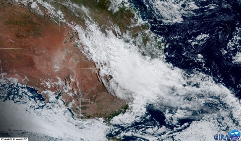
A thick stream of dense clouds and heavy rain will soak Sydney and other areas of eastern NSW over the next three days, with damaging winds and hazardous surf also on the cards from Friday.
A deepening coastal trough and associated upper-level low pressure system will cause widespread rain and thunderstorms across southern Qld, NSW and parts of Vic and Tas between today (Thursday) and Saturday.
While this weather pattern will produce severe weather that could include a month’s worth of rain in 24 hours for some places, it is not unusual for this time of year.
Autumn and winter are the peak seasons for coastal troughs and East Coast Lows along the coast and ranges between southeast Qld and Tasmania.
This week’s weather pattern is not expected to produce an East Coast Low, however it will spawn a deep coastal trough that is likely to produce a phenomenon called a black nor’easter.
Video: Thick clouds sitting over eastern Australia on Thursday morning as the system starts to take shape.
The term black nor’easter refers to a build-up of thick dark clouds, heavy rain and powerful northeasterly winds along the east coast of Australia. Black nor’easters typically bring a mix of severe weather and make the day appear darker beneath a blanket of thick rain-bearing clouds.
This week’s weather pattern will cause rain and thunderstorms to spread across southern Qld and northern, central and southern NSW between Thursday and Saturday. Rain will also spread to parts of eastern Vic and Tas on Saturday and Sunday.
The most intense period of rain and wind during the next three days will occur over central eastern NSW between Friday afternoon and Saturday afternoon. This is when the black nor’easter will be most intense, affecting parts of the Hunter, Sydney, Blue Mountains, Illawarra and South Coast districts in NSW.
Forecast models suggest that accumulated rainfall totals over the next three days could reach 50 to 100 mm over a broad area stretching from southern Qld down to southeast NSW and possibly eastern Vic. This includes areas near the coast and ranges, as well as some inland districts of southern Qld and NSW.
Higher rainfall totals are likely to occur along the coast and ranges in central eastern NSW, where parts of Sydney, the Blue Mountains, the Hunter, Illawarra and South Coast could receive 100 to 200 mm between Thursday and Saturday, with isolated totals possibly exceeding 250 mm.
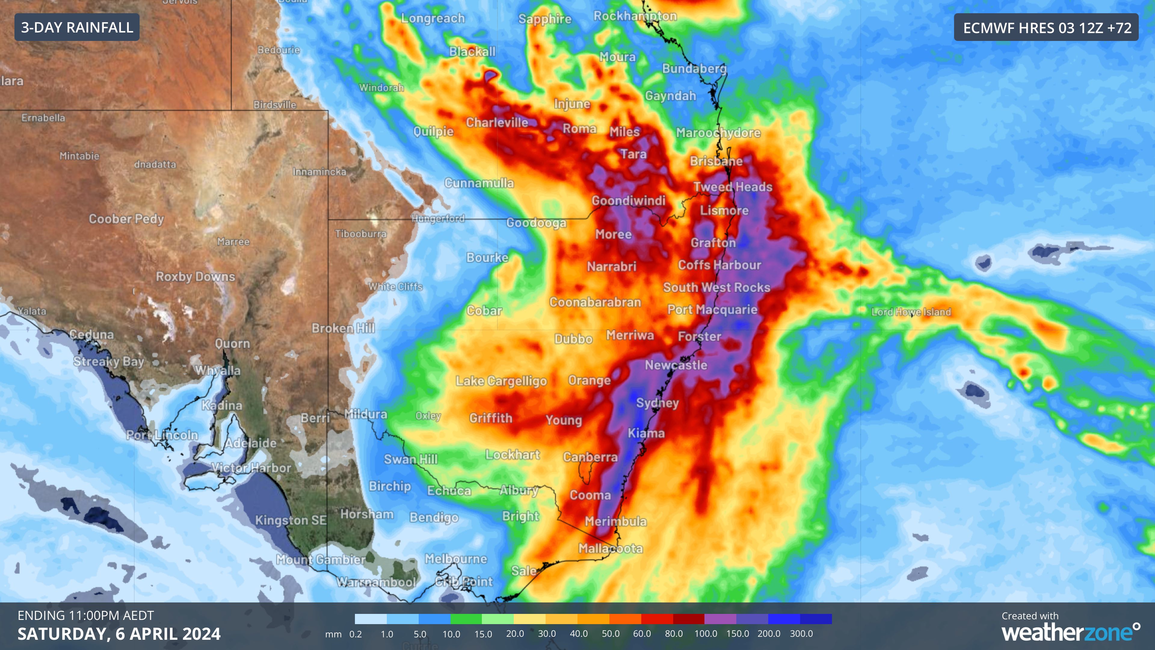
Image: Forecast accumulated rain during the 72 hours ending at 11pm AEDT on Saturday, April 6, 2024, according to the ECMWF-HRES model.
This much rain has the potential to cause flash flooding and may lead to minor to major flooding in parts of NSW from Friday or Saturday, including the Hawkesbury-Nepean River.
A burst of powerful east to northeasterly winds will also develop along the coast and ranges in central and southern NSW between Friday afternoon and Saturday afternoon. This wind surge may cause damaging wind gusts in some areas and should also whip up large and dangerous waves.
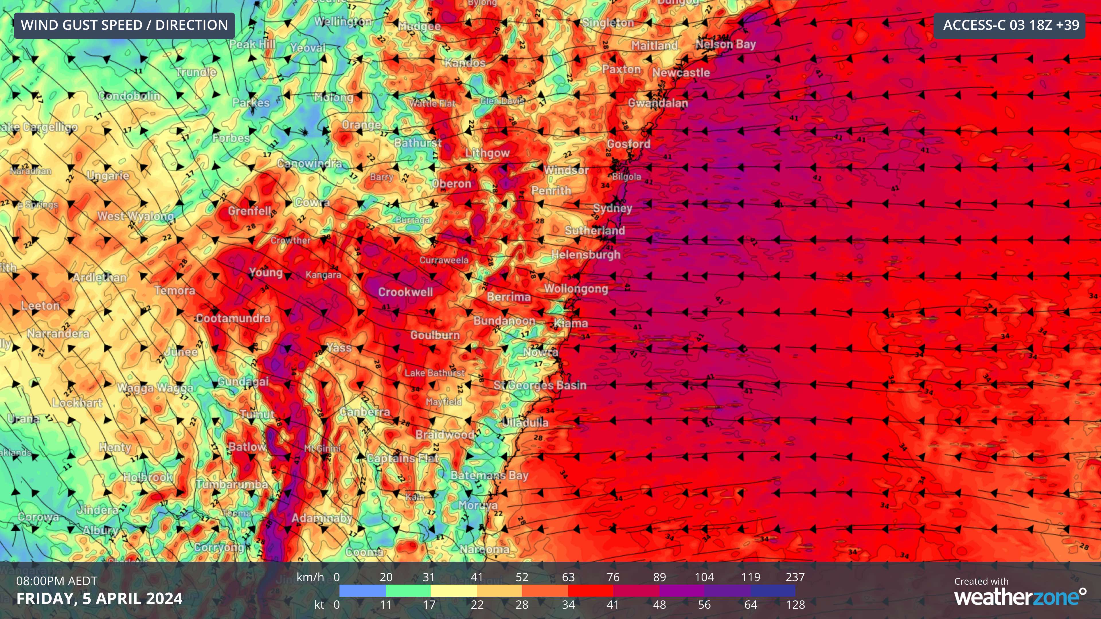
Image: Forecast wind gusts at 8pm AEDT on Friday, April 5, 2024, according to the ACCESS-C model.
As of 10am AEDT on Thursday, the following warnings were in place:
- Hazardous surf warning for the Macquarie, Hunter, Sydney and Illawarra Coasts on Friday
- Flood Watch for the Mid North Coast, Wollombi Brook, Sydney and Surrounding Regions, South Coast and parts of the North West districts in NSW
- Severe thunderstorm warning for heavy rain in parts of Maranoa and Warrego and Central West districts of Qld
- Flood watch for parts of the southern Inland and southwest catchments in Qld
- Major flood warning for the Lower Brisbane River catchment in Qld
Be sure to check the latest warnings over the next few days to keep up to date with this evolving weather event.
Rail and transport networks are exposed to severe weather risk, every day. Our services significantly improve efficiency, safety and planning.
DTN APAC, a DTN company, specialises in building customised weather monitoring and alerting solutions.
These guide transport operators to plan and respond effectively. We tailor our data and analytics to your exact requirements.
For more information, please contact us at apac.sales@dtn.com.




