Australia’s offshore oil and gas industry is underpinned by staff who work and live on offshore platforms. Like the mining industry these employees work on FIFO roster.
Transport to and from the offshore facility can be achieved via scheduled transport on Offshore Support Vessels, however these present challenges for scheduling and can be expensive.
Therefore, most of the personnel transport to Offshore Facilities is carried out by Helicopter.
Offshore helicopters fly in the most challenging weather conditions up to 250nm (463km) off the coastline of Australia.
Offshore oil and gas facilities stretch from the Timor Sea down to the Bass Strait. The oil and gas workforce are booming with the over 95% of the work force flying in and out of the platform each day.
The facilities depend entirely on offshore helicopters to transport workers, transport freight, inspect equipment, for search and rescue missions and emergency evacuations.
The meteorological and oceanographic (METOCEAN) conditions can cause the facility (figure 1) to move up and down vertically, roll from side to side or pitching when the waves and wind are adverse.
This impacts the ability for helicopters to land safely on the facility and is why metocean observations and forecasting is paramount for offshore facilities. 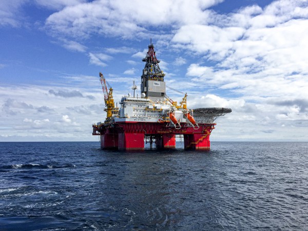
Figure 1: An offshore facility.
Helicopter transport happens 365 days a year and can occur at night and in low visibility due to fog or heavy rainfall. The weather and intense winds can blow the aircraft in the wrong direction and make it difficult to remain in flight.
Strong wind speeds and turbulent weather are more common over the ocean rather than land, which is why accurate weather forecasts are paramount for safety.
Fog and low cloud can reduce the visibility of the pilot, which can disorientate the pilot, leading to accidents. Fog and low cloud can obscure the platform making it difficult for the pilot to land the aircraft.
Rain and thunderstorms are dangerous to fly in for the same reason as fog, they reduce visibility and can also generate extraordinarily strong wind gusts.
As oil exploration and drilling technology improves, oil facilities may move into deeper water, further from land, where helicopter safety will become more important in the future.
Here at Weatherzone we provide our offshore oil and gas clients with detailed forecasts by our highly trained meteorologists. We also provide storm, strong winds, swell, fog and squall forecasting out to 7 days based on our forecast model Opticast. For more information, please contact us at businness@weatherzone.com.au.


