Prosper in a dynamic world
Search

Very wet week for the northern QLD tropical coast


Six days of heavy rain and thunderstorms are on the cards for parts of the northern and western QLD as a burst of late wet-season rain targets northeastern Australia.  

A low pressure trough and embedded tropical low are currently located over the northwestern Coral Sea. These systems will slowly drift further west in the coming days, causing a prolonged period of heavy rain and thunderstorms over Queensland’s eastern tropical coast and adjacent hinterland. 

The moisture feeding this coastal rain event will also spread further west and interact with a low pressure trough deepening across Australia’s eastern inland. This inland system is expected to produce widespread rain and thunderstorms across parts of western, central and southern QLD from this weekend into next week. 

The combined influence of these rain-bearing troughs will likely see a broad area of northern and western QLD picking up some decent rain over the coming week.  

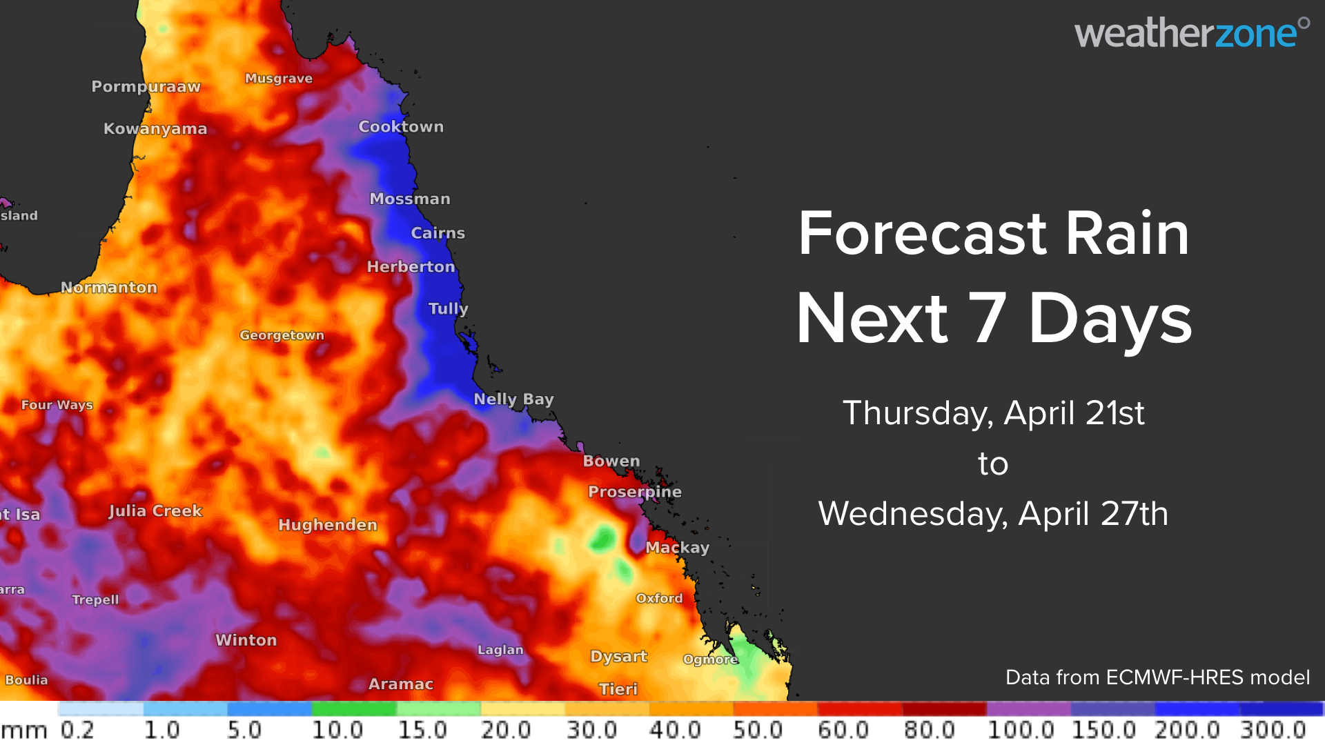
The heaviest falls will occur along parts of the eastern tropical coast and nearby hinterland, where accumulated rainfall totals should reach 150-400mm during the next seven days, with isolated areas possibly reaching around 700mm. The heaviest rain will most likely fall between about Cooktown and Townsville.

The bulk of this rain will fall between Thursday and Sunday, although some models suggest that heavy rain could linger on Monday and Tuesday as well. 

MicrosoftTeams-image (361)

Image: Forecast accumulated rain during the next four days (Thursday to Sunday), according to the ECMWF model. 

Accumulated rainfall totals of 50 to 150 mm are also possible across parts of western and central QLD between this weekend and the middle of next week.  

The map below shows the forecast accumulated rain during the week ending on Wednesday, April 27. While much of the Bowen Basin will most likely miss the heaviest rain from this system, parts of the basin could still see 100 to 150 mm during the next week. 

MicrosoftTeams-image (360)

Image: Forecast accumulated rain during the seven days ending on April 27, according to the ECMWF model. 

Weatherzone will be watching closely as this system evolves over the coming days, for more information, please contact us at apac.sales@dtn.com.  

Latest news

Satisfy your weather obsession with these news headlines from around the nation, and the world.

How does DTN help businesses monitor bushfire induced pyrocumulonimbus thunderstorms that ignite more fires?

Intense heat from bushfires during elevated fire danger days can trigger fire-induced pyrocumulonimbus thunderstorms that ignite additional fires. In early January 2026, an extreme heatwave sweeping over southeastern Australia brought catastrophic fire danger to Victoria. Intensely hot bush and grass fires spread erratically and quickly in hot, dry and gusty winds, with pyrocumulonimbus generating lightning, […]

Active seas to the north and east of Australia disrupting port and maritime operations

Seas to the north and east of Australia are experiencing periods of increased activity this week, leading to disruptions to port, maritime and offshore operations. Intense and hazardous Tasman Sea Ocean conditions across NSW’s South Coast rapidly deteriorated last Friday as a deep feed of easterly winds whipped up large and dangerous seas. The Batemans […]

Transport, emergency and energy industries flooded across Greater Sydney with weekend deluges

Transport, emergency, energy and port industries in eastern NSW and Sydney were impacted by significant flash flooding with intense and heavy rainfall this weekend. Rainfall rates between 80 and 140mm in one to three hours were registered across parts of Sydney’s Northern Beaches and Central Coast on Saturday afternoon and evening. In some areas, these […]

DTN Dangerous Thunderstorm Alerts in action with severe thunderstorms disrupting Perth industries

Severe thunderstorms impacted southwest WA and the Perth region on Sunday, December 14, 2025, triggering Dangerous Thunderstorm Alerts (DTA) by DTN for industries and businesses in the region. DTN operates Dangerous Thunderstorm Alerts (DTA) which alert businesses and industries to thunderstorms based on intensity and movement. These alerts provide advanced notice of thunderstorms moving into […]