A massive band of cloud and rain is extending from the Gulf of Carpentaria to Bass Strait and beyond, which has produced some of the heaviest October falls in years in parts of NSW and SA.
We wrote yesterday that another exceptionally wet week of weather was on its way to Australia, and especially eastern Australia, with heavy rainfall, severe storms and gusty winds.
The image below, taken just before midday on Wednesday (AEDT), illustrates the scale of the system.

Not all of the cloud in that system is currently generating rain, although a lot of it is, as you can see in the image below, in which the green areas represent rain – as regular visitors to the Weatherzone radar would know.

Overnight, solid falls were experienced in South Australia and large parts of far western NSW and Victoria. Some of the readings of note included:
- Kingscote, the largest town on SA’s Kangaroo Island (pop. 1800) saw 36.6 mm, its heaviest daily October rain in 22 years.
- Wilcannia, the outback NSW town on the Darling River saw a very handy 34.8 mm, its heaviest October drop in 12 years.
- Lameroo in SA’s Murraylands forecast district had 31 mm, which was its highest daily fall in any month for almost three years.
As this system tracks its way slowly eastwards, already saturated catchments of the Murray Darling Basin and rivers east of the Great Dividing Range in NSW, Victoria and Queensland can expect flooding.
Numerous flood warnings are in place, especially for rivers in western and central NSW so please check our warnings page for updates.
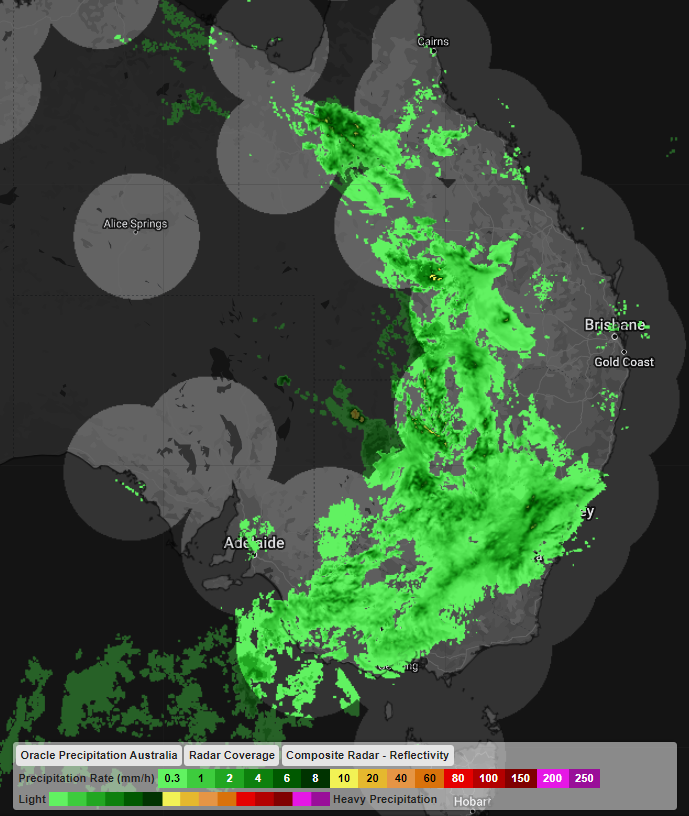
The image below shows Oracle capturing the rain and thunderstorms in far northwestern NSW and Southwestern QLD on Wednesday afternoon, which was missed by traditional radar coverage (lighter circles below).

Image: Radar coverage (lighter circles) and Oracle precipitation on Wednesday afternoon, October 5, showing large gaps in traditional radar coverage covered by Oracle.
Oracle is a ‘radar’ system, which enables users to see rain as its happening anywhere in the world. In addition to tracking current rain, Oracle also provides live forecasts of rainfall rates, lightning, and cloud for up to three hours in advance, for anywhere in the world.
It does this by feeding live satellite imagery, lightning data and nearby radar imagery into the forecast system. This cutting-edge technology was built in collaboration with Solcast. For more information on Oracle, please contact us at apac.sales@dtn.com.


