Prosper in a dynamic world
Search

Sydney’s fastest 2000 mm amid record-wet start to 2022


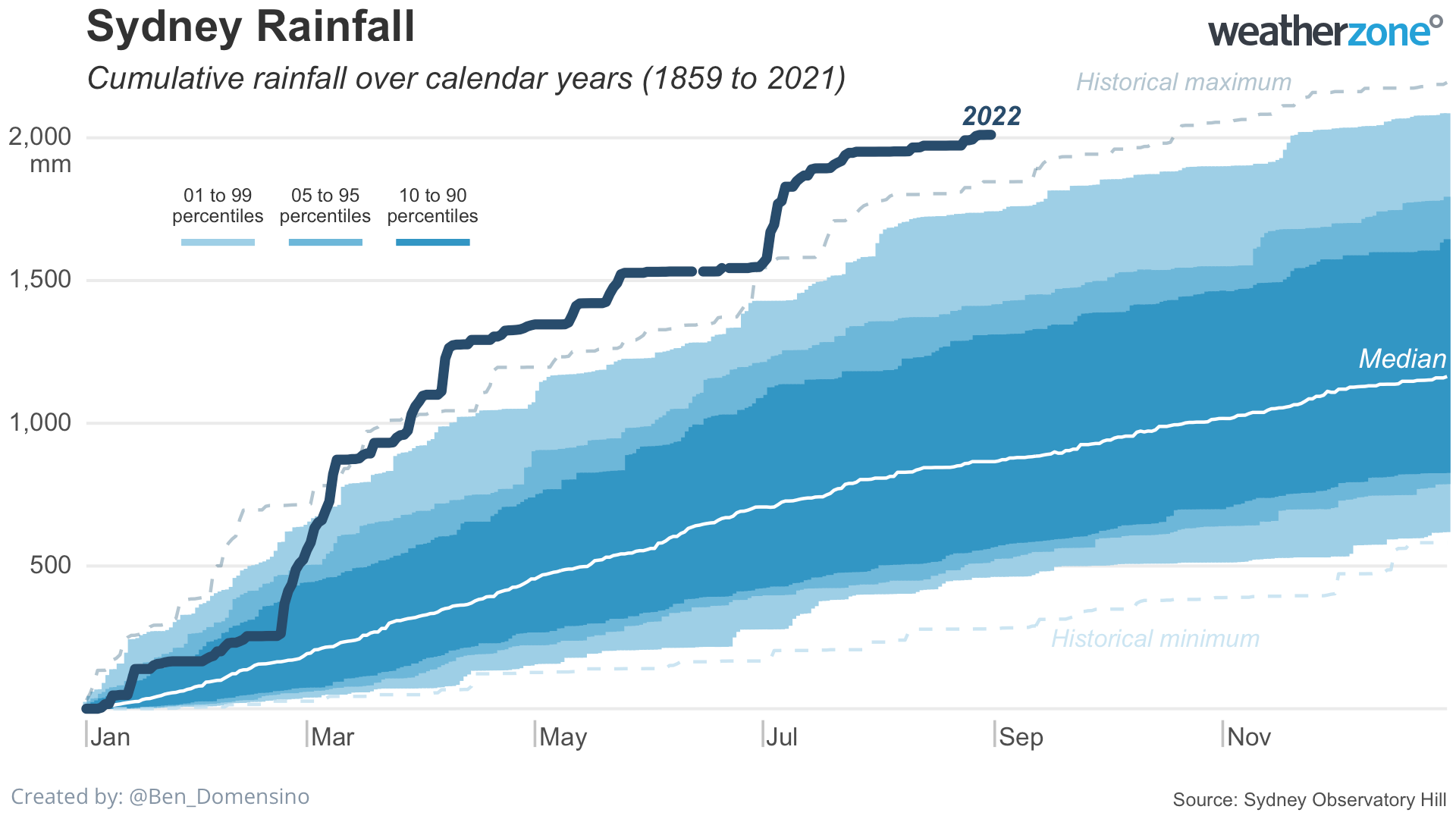
Sydney just experienced its wettest January to August period in 164 years of records, with the city also obliterating a long-standing record for the shortest time to amass two metres rainfall in a single year.

The weather station at Sydney Observatory Hill, located next to the iconic Harbour Bridge, registered 2010.6 mm of rain between January 1 and August 31 this year. This is Sydney’s highest January-to-August total in records dating back to 1859, beating 1846.2 mm during the same period from 1950.

Despite only being 8 months into 2022, this is already Sydney’s fifth wettest year in 164 years of records.

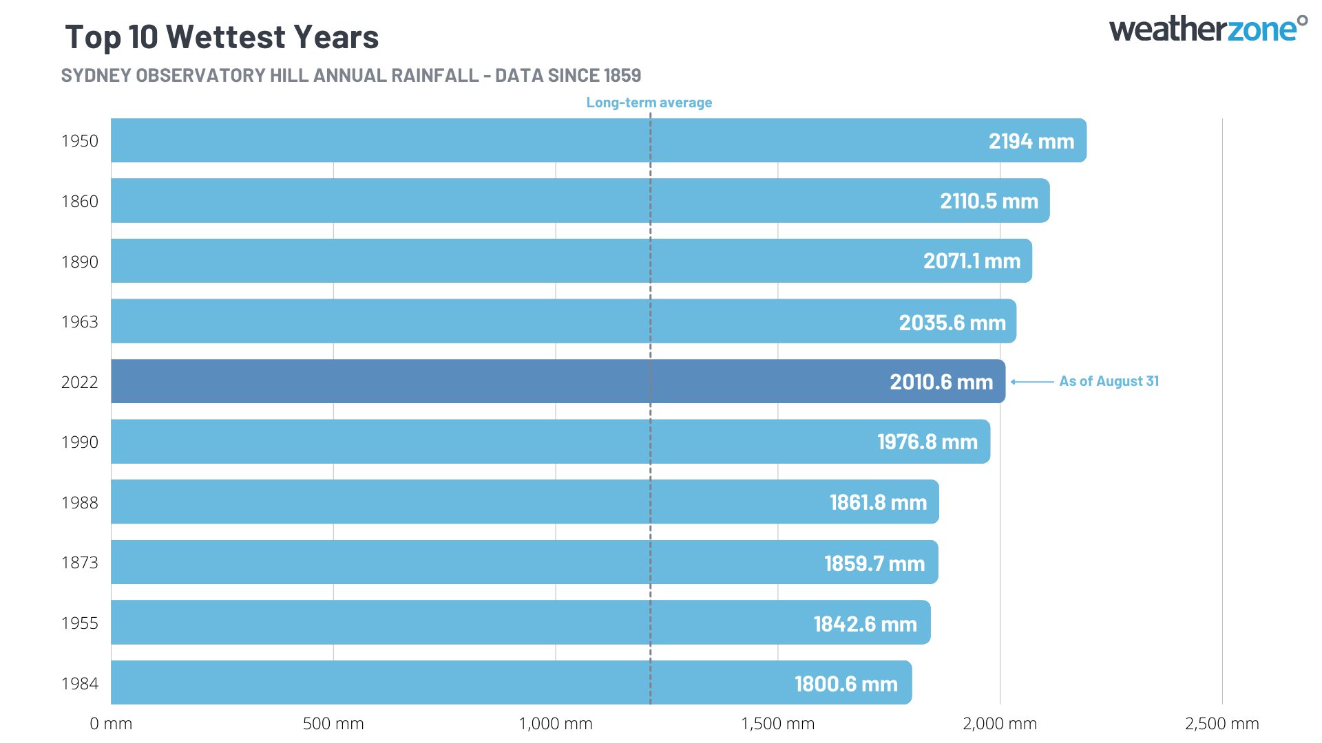
But while four other years have also exceeded two metres of rain in Sydney, none did it anywhere near as fast as 2022.

This year, the Observatory Hill rain gauge tipped over 2000 mm on Friday, August 26. This was almost two months earlier than the previous fastest two-metre rainfall record, which was October 19 in 1950.

Sydney only needs to receive another 183.5 mm of rain to make this its wettest year on record. This feat is well within reach, considering the city’s long-term average September-to-December rainfall is 305.7 mm and above-average rain is anticipated over eastern NSW in the coming months. For more information, please contact us at apac.sales@dtn.com.

Latest news

Satisfy your weather obsession with these news headlines from around the nation, and the world.

Perth sets rainfall streak not seen in 18 years as water storage levels fall

For four months in a row, Perth has exceeded its average monthly rainfall – the first time this has happened in the traditionally wet winter and spring period since 2007. Perth reached its September average of 79.3mm during light showers on Tuesday and Wednesday. Another 13.2mm of rain then fell in the 24 hours to […]

DTN remote sensing captures rain and thunderstorms lashing Solomon Islands

Aviation, mining and shipping industries in the Solomon Islands and other South Pacific nations are often unable to use traditional radar to warn of incoming storms that disrupt operations and put workers in harm’s way. DTN APAC offers a suite of remote sensing weather solutions that give businesses and industries in remote areas around the […]

Negative Indian Ocean Dipole officially underway – here’s what it means for Australian businesses and industries

A negative Indian Ocean Dipole (IOD) event is now underway, increasing the likelihood of above average rain over large parts of Australia in the coming months. What is the Indian Ocean Dipole (IOD)? The IOD is an index used to monitor sea surface temperatures across the tropical Indian Ocean. It’s an important index for the […]

La Niña more likely this year after BoM switches to new index – what does this mean for Australian businesses?

The likelihood of La Niña occurring in 2025 has increased due to a change in the way the Bureau of Meteorology calculates sea surface temperature anomalies in the tropical Pacific Ocean. What is La Niña? La Niña refers to a distinct pattern of sea surface temperatures across the tropical Pacific Ocean. When La Niña is […]