
As most people know, it’s been a super wet year in Sydney, but this could be the week when our largest city officially surpasses its highest rainfall total in 164 years of records dating back to 1858.
- 2022 is already Sydney’s 2nd-wettest year on record, with 2129.6 mm in the gauge at the city’s official station at Observatory Hill as of 9am Wednesday, October 5.
- The current wettest year on record was 1950, with 2194 mm for the whole year.
- At this time of year in 1950, only 1960.5 mm had been recorded.
So as you can see, Sydney is well on track to breaking the old 1950 record, and as mentioned at the top of this story, it’s pretty likely to happen this week.
Sydney needs another 64.4 mm to equal the old record, and it just so happens that forecast models predict around 70-110 mm up until 9am next Monday.
Indeed, all models have over 100 mm on the cards for at least some part of the greater Sydney region. Chances are, that record will be gone within the next week.
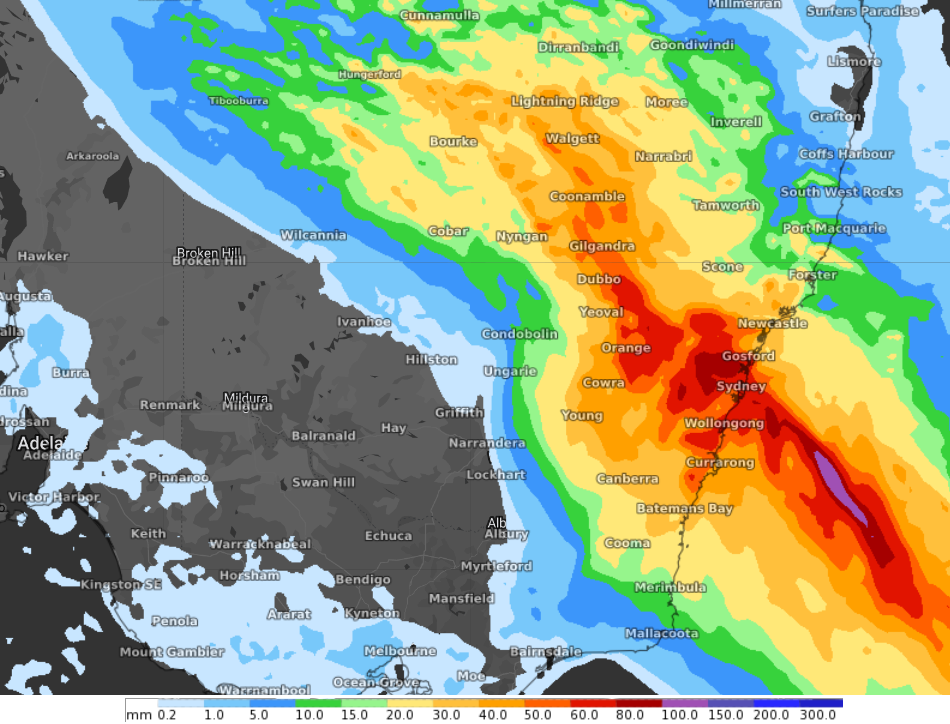
Image: This is just the 24-hour accumulated rainfall to 11am Sunday, October 9. Potentially, Sydney could see the 82 mm it needs to break the record with just the weekend’s rain.
So what’s the story with this latest wet weather system?
As we wrote earlier yesterday, Australia is in for yet another wet week of heavy rainfall, with severe storms and gusty winds set to impact most of the country, as a series of low pressure troughs drag down moist tropical air from the Indian Ocean.
This system will affect a vast area, and we’ll concentrate on those areas in our stories throughout the week. But to return the immediate focus to Sydney, the day-by-day outlook for the week is for moderate totals of rain around 10-15 mm on Wednesday, Thursday and Friday, before heavier rain kicks in over the weekend with totals potentially double that.
Weatherzone meteorologist Joel Pippard says that if – as currently forecast – the southerlies strengthen on the weekend, then we should definitely beat the record.
So get your washing hung out this Tuesday evening if you can, then break out the brollies from Wednesday onwards if you’re in Sydney. Heard that kind of forecast much this year?
As ever, please check our warnings page for the latest flood and river level information. The coming weather system has the potential to cause major flooding in numerous rivers in the already saturated Murray-Darling Basin, where most rivers are already at the moderate flood level. Northern Tasmania is also at risk of flooding.
Severe storms and gusty winds will also likely follow the heaviest rain, particularly over SA and western Qld and NSW. For more information on Weatherzone’s seasonal heavy rainfall and flood forecasting, please contact us at apac.sales@dtn.com.




