
It’s not going to rain everywhere, every day, let’s be clear about that. But a series of weather systems will deliver rain to virtually all parts of Australia over the coming 10 days.
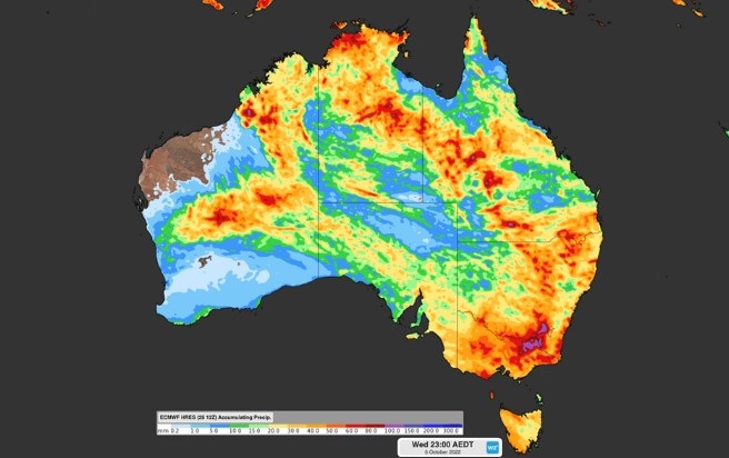
The graphic below shows the total accumulated rainfall which we can expect between today (Monday, September 26) and next Wednesday, October 5.
As you can see, heavy rain is expected in the southeast, and indeed we wrote about that earlier today in this story, as yet another rain and storm-bearing low pressure trough crosses the most heavily populated corner of the country.
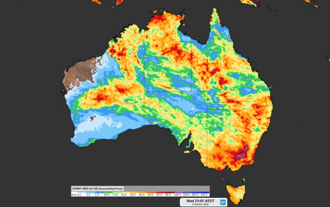
Image: It’s not often you see the whole country “coloured in” like this. Source: ECWMF.
But as mentioned, the picture above speaks about more than this week’s system.
Numerous weather systems are expected to impact the country in the next 10 days or so, including a low pressure trough which could deliver significant unseasonable rainfall to northwest WA’s Kimberly and Pilbara districts early next week.
Those two regions experience almost no rainfall on average at this time of year.
- For example Broome, on the Kimberly coast, has had no rainfall in September 2022 to date.
- Indeed Broome’s two driest months are Sept and Oct, with an average of just 1.4 mm in each month.
- Yet Broome is located right where one of those reddish blobs sits, suggesting potential rainfall in the 50-80 mm range.
You might also note that the graphic above shows Darwin getting an early October drenching, and while the heart of the Top End wet season falls in midsummer and early autumn, October has an average of 70.2 mm, so a decent Darwin drop is not too unusual at this time of year.
It’s still too early predict exactly how that particular system will play out. But as mentioned, we can say with confidence that almost the entire country can expect to see at least some rain between now and the middle of next week.
We’ll keep you updated as these systems start to make their impact felt.
For more information on Weatherzone’s heavy rainfall, thunderstorm and cloud forecasting services, please contact us at apac.sales@dtn.com.




