The NSW floods have been declared a natural disaster with the worst flooding since 1990 expected to inundate the Hawksbury-Nepean basin in Sydney’s west. Over 18,000 people have been evacuated from their homes in NSW, as today delivers the 5th consecutive day of heavy rainfall for NSW and the 4th for Sydney.
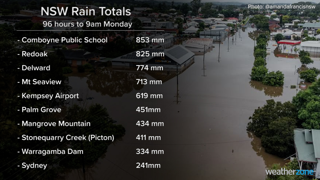
The heavy and persistent rainfall has impacted a broad area extending from southeast QLD to southern NSW, with nearly a metre of rain falling in some areas. Near 900mm of rainfall in 4 days has fallen at Comboyne high school (Mid North Coast NSW) to 9am today, Monday 22 March. During the same period Sydney received 241mm and Warragamba Dam collected over 334mm (Figure 1).

Figure 1: NSW accumulated 4-day rainfall totals to 9am Monday, 22/03/21.
The 4-day rainfall totals over the Warragamba Dam catchment led to about 500 gigalitres per day (GL/day) being released from the dam on Sunday night, which is equivalent to the volume of Sydney Harbour. At 10:51 am EDT on Monday 22 March 2021 The Hawkesbury River at North Richmond (WPS) was at 13.16 metres and falling with major flooding (Figure 2). Renewed rises are possible with forecast rainfall to continue into tomorrow, before easing by Wednesday.
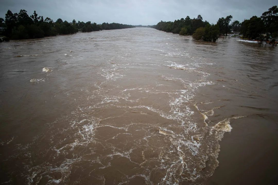
Figure 2: Hawsbury River at North Richmond water levels on Monday, 22/03/21 at 8:46am.
With rivers rising, residents of many low-lying areas of the Hawkesbury-Nepean basin in the Sydney’s west have been urged to leave. So far there has been 5000 insurance claims submitted for the event, with the NSW floods declared an insurance catastrophe today.
Looking ahead, another injection of moisture from the tropics will fuel more widespread rain and thunderstorms across NSW during today and tomorrow. Unfortunately, this heavy rainfall is likely to continue falling into already saturated catchments and flooded river systems in the state’s east.
Widespread rainfall between 50-150mm is forecast today on and east of the Great Dividing Range (including Sydney area), with the highest totals of 200mm forecast for the Mid North Coast area. The rainfall is likely to continue tomorrow, before easing on Wednesday. A similar situation is evolving to the north of the border in Queensland where emergency warnings for southeast QLD have been issued with severe storms forecast today.
While the rainfall is likely to ease on Wednesday, it will likely take a few days more after rainfall stops for the swollen rivers to return to normal levels.
So, what is causing this severe weather?
A near stationary coastal trough sitting off the NSW coast has combined with tropical moisture leading to large amounts of rainfall being dumped over NSW and QLD. The Satellite picture shows extensive cloud over NSW and QLD as well as the coastal trough (blue dashed line over the NSW coast) in figure 3.
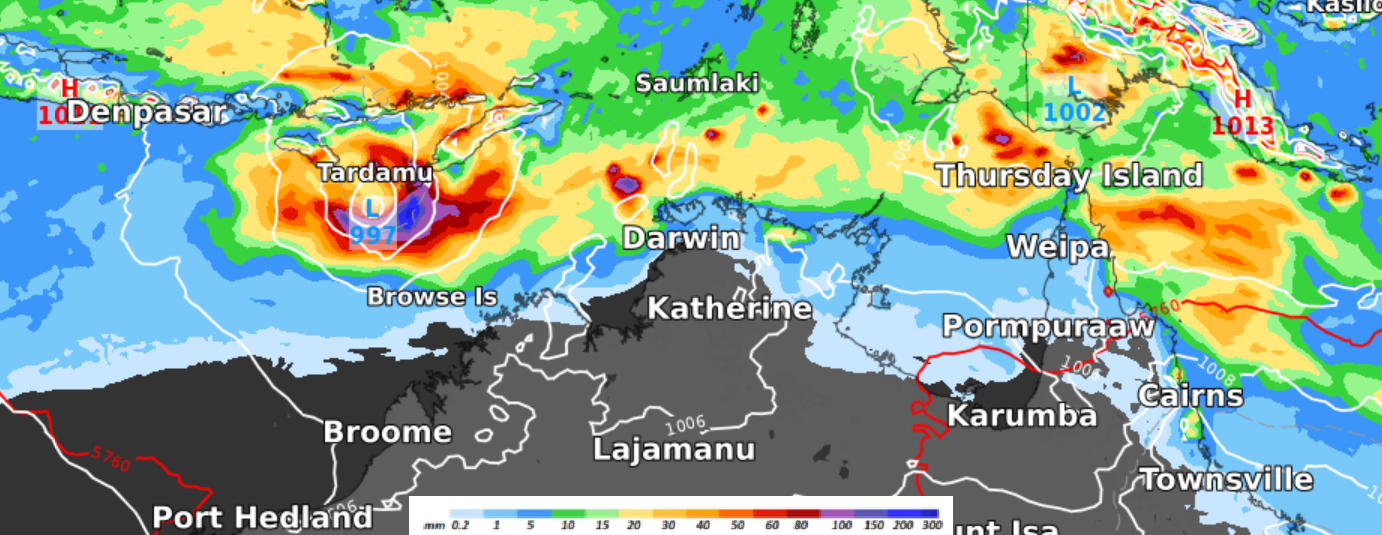
Figure 3: MSLP at 5am on Monday the 22nd of March 2021.
Of course, this has impacted many businesses, industries and communities. This is a serious and life-threatening flooding event. Be sure to keep up to date with the latest forecasts, warnings and flood information for your area. And never drive through floodwater.
During this event Weatherzone has provided many businesses with up-to-date forecasts and consultancy. Weatherzone has also provided expert advice, event reports, storm tracking and alerts to the insurance industry during this event. If you are interested in receiving Weatherzone’s services for your business, please contact us at apac.sales@dtn.com.


