

Prosper in a dynamic world
Search

Is El Nino on the horizon?

Some computer models suggest that El Niño could return next year, bringing an abrupt shift in one of our planet’s major climate drives following three consecutive years of La Niña.

The graph below shows the most recent computer-based El Niño-Southern Oscillation (ENSO) outlook from the U.S. Climate Prediction Center (CPC) and Columbia University’s International Research Institute for Climate and Society (IRI).
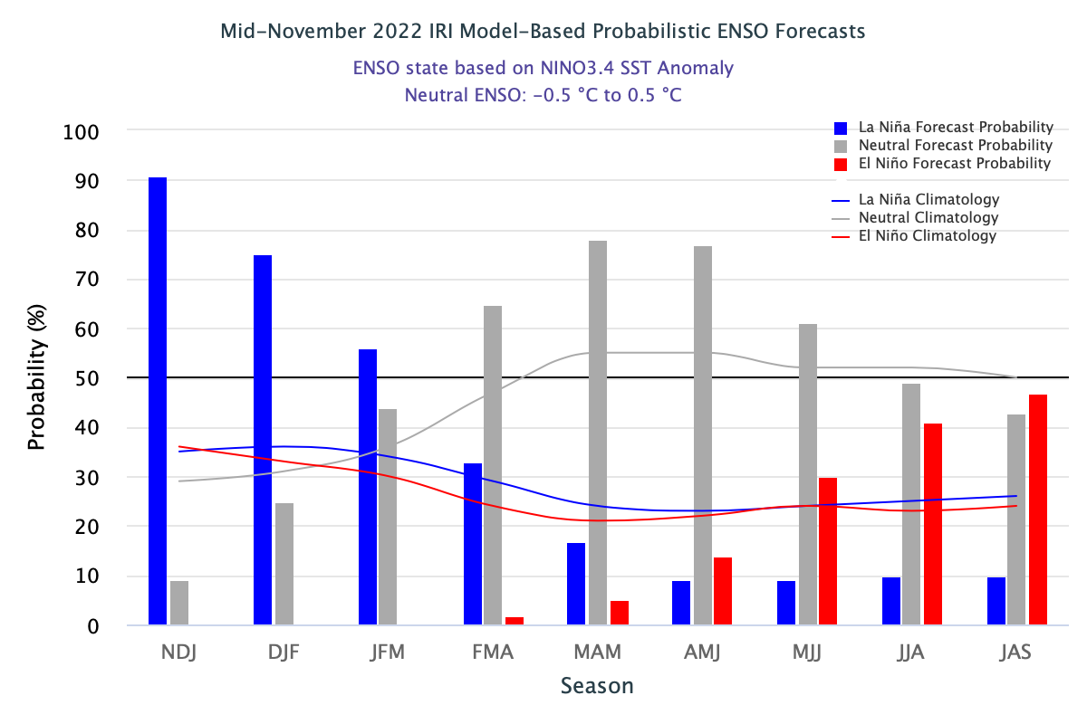
Image: Model-based ENSO outlook for the next nine months. Source: CPC/IRI

The bars on the graph above represent the probability of La Niña (blue), El Niño (red) and neutral conditions (grey) occurring in the tropical Pacific Ocean during each of the next nine overlapping three-month periods.

The graph shows that La Niña has a 90 percent likelihood of remaining in place over the next three months. Neutral conditions then become more likely than La Niña from late in the Southern Hemisphere’s summer through until the middle of 2023.

Further into the future, this outlook suggests that El Niño becomes the most likely state for the Pacific Ocean late in the Southern Hemisphere’s winter in 2023. This is the first time in around three years that the monthly CPC/IRI outlook has favoured El Niño as the most likely category in the Pacific Ocean.

It is important to point out that the U.S. CPC and IRI use slightly more relaxed threshold than Australia’s Bureau of Meteorology for identifying La Niña and El Niño.

Also worth highlighting is that this outlook becomes less reliable the further it looks into the future, so predictions for the middle of next year should be treated with some caution. More reliable ENSO outlooks will become available early to mid-next year.


Latest news

Satisfy your weather obsession with these news headlines from around the nation, and the world.

A warm, light wind spring ahead for the NEM

A strong El Niño and an unusually stable Antarctic polar vortex are setting up a spring signal of light winds, elevated solar output, and a real risk of high-intensity heatwaves for the NEM.   This forecast could be a major flip to what the National Electricity Market (NEM) has experienced so far during Winter 2026. On 1 July 2026, the NEM […]

Habagat and successive typhoons trigger widespread flooding in the Philippines

Three consecutive weeks of enhanced southwest monsoon (Habagat) and back-to-back typhoons have flooded Luzon and the Visayas, grounding flights, triggering distribution power outages, cutting off transport corridors, and raising landslide risk across mining-dense provinces like Benguet and the Cordillera. The disruption is far from over with PAGASA expecting the monsoon to remain in place until […]

Australia’s Spring 2026 Bushfire Outlook: Increased Risk Across Seven States and Territories

Fire agencies, land managers and businesses are being urged to prepare as the AFAC spring seasonal bushfire outlook, released on August 19, 2026, warns of elevated bushfire risk across Australia this season. The outlook identifies above-average fire danger across seven states and territories, with conditions driven by a combination of elevated fuel loads, an El Niño […]

Businesses under pressure: how this powerful high will affect Australian industries

A very strong high pressure system centred over Tasmania will impact southern and eastern Australia’s weather over the coming days. How strong is this high pressure system? Mean Sea Level Pressure (MSLP) has already reached 1039.3 hPa at Ouse, Tasmania on Sunday morning, and is forecast to peak at 1041 or 1042 hPa on Monday […]

