A powerful blast of gale force winds moved up the southern and central NSW coastline on Tuesday night and early Wednesday, impacting NSW port operations.
The wild weather during the last 48 hours has been driven by an East Coast Low which has brought heavy rainfall, flooding, gale force winds and damaging surf to NSW.
The satellite image below shows the East Coast Low sitting off the South Coast of NSW on Wednesday morning.

Image: Visible satellite image at 9:50am on Wednesday, March 9.
On Tuesday night, Sydney Airport observed gale force winds, with the 10-minute average wind speed peaking at 67km/h at 9:26pm. Average 10-minute wind speeds of this magnitude are a huge concern for port managers and Pilots. The wind gusts were also strong with the site recording at 95km/h wind gust at 9:20pm.
Molineux Point, near Port Botany saw a 111km/h wind gust at 9:34pm and Kurnell nearby observed a 100km/h wind gust at 9:53pm,
Damaging wind gusts in excess of 90km/h are possible about the coast and adjacent hinterland stretching from the Mid North Coast down to the South Coast on Wednesday.
The map below shows strong south to southwesterly winds are predicted across the southern and central coastline at 2pm on Wednesday, March 9.

Image: ECMWF 10m wind forecast at 2pm on Wednesday, March 9.
The low will continue to move south to southeast away from the NSW coast during Wednesday, easing winds later on Wednesday.
The strong southerly winds are also whipping up very heavy surf between the Mid North Coast and the South Coast on Wednesday.
Wave heights of around 3 to 6 metres are likely to impact the central coastline during the next 48 hours. The south facing beaches are most likely to see coastal erosion and localised damage.
The large and powerful surf will continue to impact the central NSW coastline into Thursday, before easing on Friday.
How does the weather impact port operations?
The process of navigating a ship through volatile waters and through a small port is a challenge. For this reason, a trained pilot jumps on the ship outside of the port or harbor and manoeuvers the vessel through the challenging waters.
Large waves, high tides, strong and gusty winds and low visibility can all make the pilot’s job very difficult.
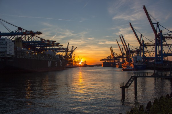
As if navigating through the port isn’t difficult enough, unloading containers from the ship can be a laborious task, particularly when the weather is adverse.
Unloading all the containers from a ship can take up to 3 days, especially when the ports are unloading bulk carriers and container ships with up to 10,000 containers.
The cranes that lift the containers off the ship and stack them can be over 73 metres high, with a boom that reaches 105 metres in the air at full height. The height at which these cranes extend into the air makes the equipment more vulnerable to intense winds of adverse weather.
Crane operations need to be suspended and in extreme winds the crane needs to be taken down. Strong winds can also move the ship off the platform.

Bulk carrier ships are huge, they can be up to 350 metres long and up to 45 metres in height and are very exposed to strong winds. Strong winds can move the ship off the platform, where its being unloaded.
Weather impacts all aspects of port operations affecting arrival, cargo transfer and storage.
Weatherzone’s Port specific forecasts
Weatherzone Ports is an all-in-one web-based interface for minimising risk to staff, infrastructure and the environment at your port, whilst acting as an important planning tool for maximising efficiency. Weatherzone brings together the most accurate weather and oceanographic information. Some of the services we offer ports are;
- Lightning strike detection.
- Dangerous thunderstorm alerting and tracking
- Automatic alerts based on current and future threats of lightning winds, waves and tides.
- Expert advice from our experienced meteorologist team.
- Severe weather risk analysis out to a week to ensure adequate time to prepare and plan.
- Seasonal or long-term outlooks out to 6 months detailing wind, wave and severe weather risk.
- An easy-to-use tool for Operations, Planning and OH&S.
For more information on our port forecasts and services, please contact us at apac.sales@dtn.com.


