Potentially severe thunderstorms could interrupt a warm Australia Day in Sydney and surrounding areas of central NSW this Thursday.
A warm and mostly sunny morning will entice millions of people to head outdoors across the Greater Sydney region on the Australia Day public holiday this Thursday.
Beaches will be bustling, parks will be packed, and barbecues will be sizzling from the coast right up to the Blue Mountains.
But the pleasant morning weather will hide the threat of afternoon thunderstorms that could become severe.
After a warm and sunny start to the day, a few fluffy white clouds will start to develop above and to the west of Sydney in the late morning or early afternoon. Most people probably won’t even notice these seemingly benign puffy cumulus clouds.
But as the day wears on, a few of these cumulus clouds will continue to grow to form larger cumulus congestus clouds. These towering clouds may start to catch the attention of more onlookers and could even produce a few showers.
☁️ We do love a good cumulus congestus! This was seen over Sydney’s north western suburbs yesterday. pic.twitter.com/1VAul0g84Q
— BBC Weather (@bbcweather) January 6, 2021
The atmosphere will be unstable enough on Thursday afternoon for a select number of clouds to evolve into thunderstorm-producing cumulonimbus clouds. These storm clouds will most likely start to develop around the ranges and western parts of Sydney, but could also form over, or move over central and eastern parts of Sydney by mid-to-late afternoon.
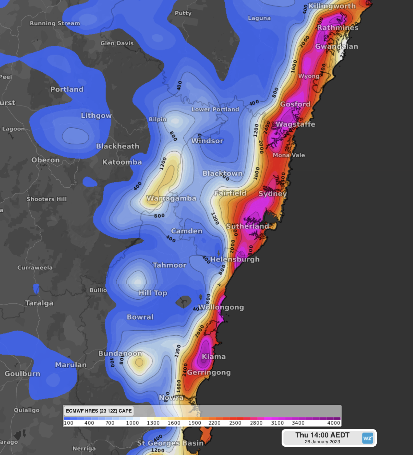
Image: Convective Available Potential Energy (CAPE) over Greater Sydney on Thursday afternoon. Areas in red and purple are more unstable and can provide more energetic thunderstorms.
Some of Thursday’s thunderstorms could become severe, with damaging winds, heavy rain and large hail all a risk.
Unfortunately, it is not possible to know exactly where or when the Australia Day storms will strike until they start to form. So, anyone spending this Thursday in Sydney or other areas of central NSW should pay close attention to the sky and the latest severe thunderstorm warnings issued by the Bureau of Meteorology.
At this stage, Sydney is forecast to reach a top of 31ºC in the city and 35ºC in the west. However, with plenty of moisture in the air pushing up the humidity, it should feel like the mid-30s in the city and high-30s in western suburbs.
DTN APAC provides a simple traffic light system (green, amber, red) to forecast thunderstorms and other extreme weather for our clients. This allows you to quickly assess which days the weather will have the highest impact on your operations and assets. To find out more, please email us at apac.sales@dtn.com.


