A broad mass of very hot air is sweeping across Australia this week, causing a heatwave in part of every state and territory and sending temperature towards 40ºC in at least two capital cities.
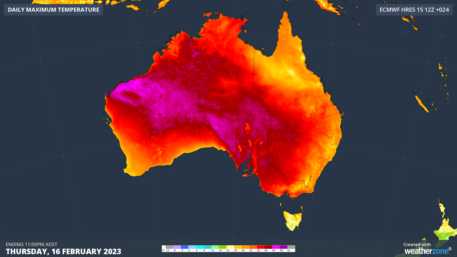
The image below shows the forecast maximum temperatures over Australia today, Thursday, February 16. The big pool of pink shading represents areas that are hitting 40ºC or higher.

Image: Forecast maximum temperature on Thursday, February 16, 2023, according to the ECMWF-HRES model.
As you can see on the image above, the heat is most intense over the nation’s interior and along the northwest coast of WA. However, a tongue of hot air is also spreading into the nation’s south and southeast, thanks to northerly winds ahead of an approaching low pressure trough.
Adelaide reached 39.7ºC shortly before 3pm on Thursday, which was the city’s 2nd highest temperature so far this year. Across the border, Melbourne’s temperature rose to 37.1ºC shortly after 4pm. These temperatures were both 11ºC above average for this time of year.
Today’s heat caused a few pockets of Extreme to Catastrophic fire danger ratings in SA, with some areas in the state experiencing their worst fire weather in about three years.
Unfortunately, the heat will persist in Australia’s southeast through tonight and into Friday.
Both Adelaide and Melbourne are going to stay oppressively warm into this evening, with temperatures possibly still sitting around 28 to 30ºC at 9pm local time. While Adelaide will have some cooler relief tomorrow, Melbourne is in for another day of heat on Friday.
Melbourne could reach around 38 to 39ºC on Friday, with potential to hit 40ºC in the afternoon. This would be Melbourne’s first 40ºC day in more than three years, with the last one occurring way back on January 31, 2020. Below is one computer model’s prediction for Friday’s maximum temperature in Victoria.
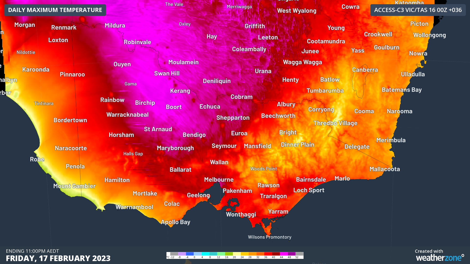
Image: ACCESS-C forecast maximum temperature on Friday, February 17, 2022.
Friday’s hot weather will help cause High and possibly Extreme fire danger ratings in Victoria, prompting the Country Fire Authority to declare total fire bans for the Central and North Central districts.
Tasmania will also experience a brief burst of heat on Friday, with Hobart predicted to reach around 32ºC, Launceston forecast to hit 33ºC and Ouse possibly heading for 34ºC.
The huge scale of the hot air mass sloshing around Australia this week will cause a low intensity heatwave in part of every state and territory. This includes most of NSW, where the mercury could climb to around 38ºC in western Sydney on Saturday.

Image: Forecast heatwave categories for the three-day period starting on Friday. Source: Bureau of Meteorology.
Some places in WA will experience a Severe to Extreme heatwave in the coming days, with temperatures possibly approaching 50ºC in the northwest of WA by Saturday.
The Red Cross website has useful information about how to prepare for and cope with heatwaves in Australia.
To find out about Weatherzones temperature and heatwave forecasts, visit our website or email us at apac.sales@dtn.com.


