
An early-spring outbreak of thunderstorms produced around 500,000 lightning strikes over Australia during the last 24 hours, with more heavy rain and flooding still to come.
A low pressure trough and low pressure system interacting with copious tropical moisture produced widespread cloud, rain and thunderstorms over Australia on Wednesday into Thursday morning.
The video below shows this volatile weather spreading over the eastern half of Australia, with lightning occurring continuously for 24 hours and still going into Thursday.
Video: Visible satellite images combined with lightning strike observations between Wednesday morning and Thursday morning.
This storm outbreak triggered warnings for severe thunderstorms in several states. Late on Wednesday, Ballera Gas Field in western QLD recorded a wind gust of 109 km/h. Earlier in the day, SA’s Port Augusta copped 22 mm of rain in half an hour, gaining more than its monthly average in less than 20 minutes and doubling its monthly average in under two hours.
Massive storm has struck #portaugusta bringing torrential rain, hail, lightning and thunder. More on @SpencerGulfNN with @madelinemaykerr pic.twitter.com/ZjbHJsYJXR
— Daniel Pizarro (@DJPizarro) September 7, 2022
Total Lightning Network detected around 500,000 lightning strikes within an 800 km radius of Moomba during the 24 hours ending at 9am ACST on Thursday. These strikes covered parts of four states and territories.
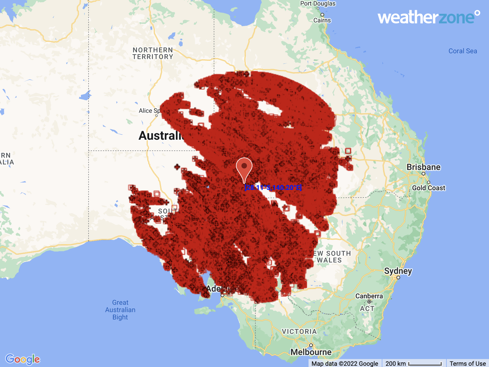
Image: Locations of 495,875 lightning pulses detected within an 800 km radius of Moomba, SA during the 24 hours ending at 9am ACST on Thursday, September 8.
During the 24 hours to 9am on Thursday, rainfall totals of 20 to 40 mm were recorded in SA, VIC, NSW and QLD, with 50 to 60 mm hitting the ground in parts of western NSW.
Rain, thunderstorms and blustery winds will continue to spread over parts of southern and eastern Australia between Thursday and Saturday, as the low and trough move slowly towards the east.
This will include widespread moderate to heavy rain, with flood watches already in place for numerous river catchments in NSW and VIC. Severe weather warnings have also been issued for damaging winds in Victoria’s eastern ranges on Thursday.
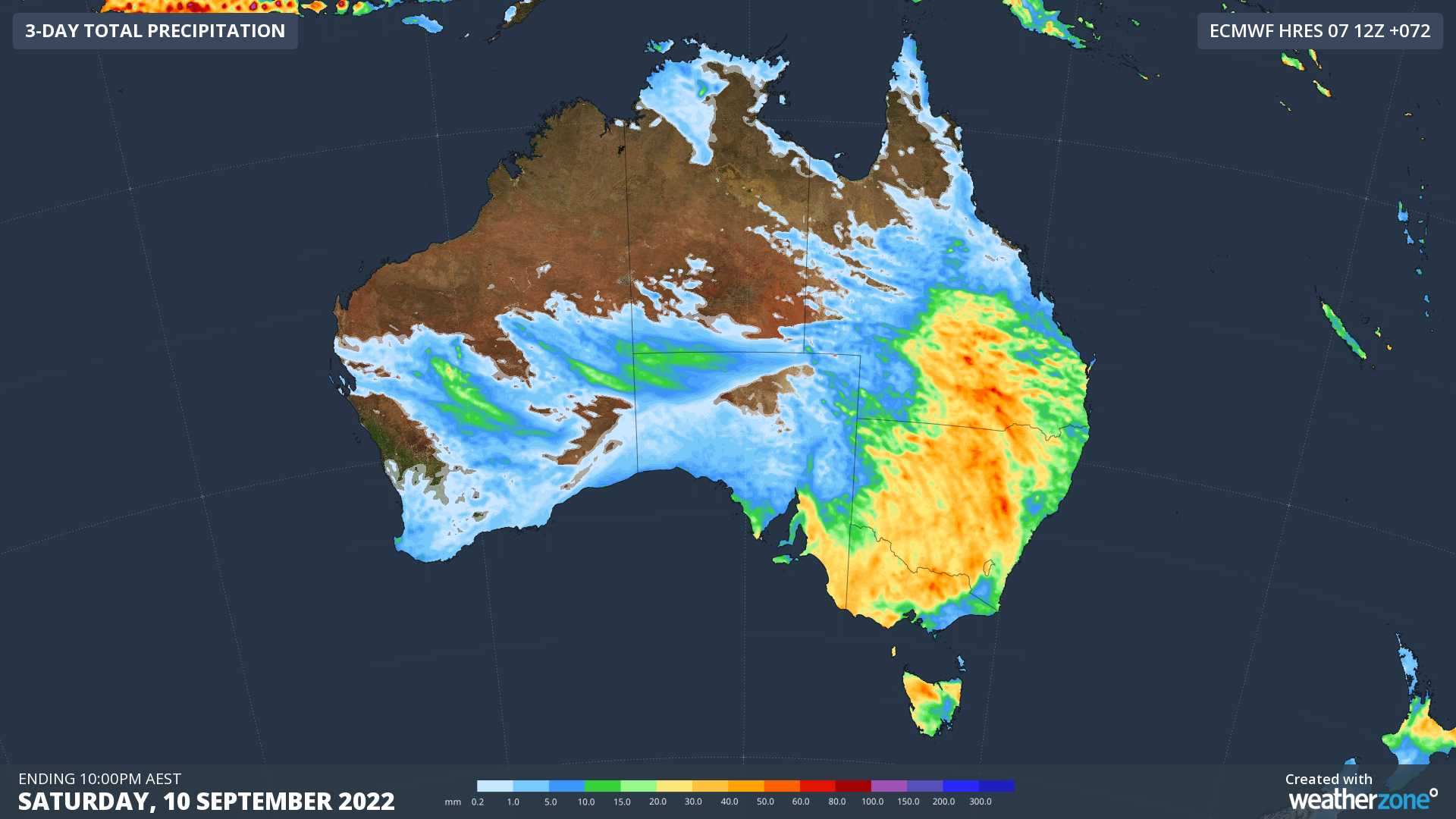
Image: Forecast accumulated rain between Thursday and Friday, according to the ECMWF-HRES model.
Be sure to check the latest warnings for the most up-to-date information on this ongoing severe weather event.
How can Weatherzone help this storm season?
Weatherzone’s real-time alerting system provides accurate lightning strike detection. Real-time and warning alerts are issued to any device across your business via SMS, email, web interface and our dedicated Weatherguard app.
Total Lightning Network
Our network of regional and global sensors detect lightning strikes within your proximity thresholds. The high resolution sensor networks provide unparalleled detection accuracy and efficiency (<200m), ensuring storm cells of any size are captured and sites are alerted to respond respectively.
Stormtracker Visualisation
Stormtracker, Weatherzone’s fully visualised Geographic Information System (GIS), plots ‘live’ lightning strikes, aged to over 60mins. This provides enhanced spatial awareness and understanding of the potential threat of storm activity on your operations and valuable assets.
Weatherguard App
Our dedicated business app, Weatherguard, delivers lightning and severe weather notifications to your site staff, based on the thresholds you provide. This equips your team with the precise knowledge to inform their operational safety decisions, and guard against unnecessary shutdowns.
For more information, please contact us at apac.sales@dtn.com.




