
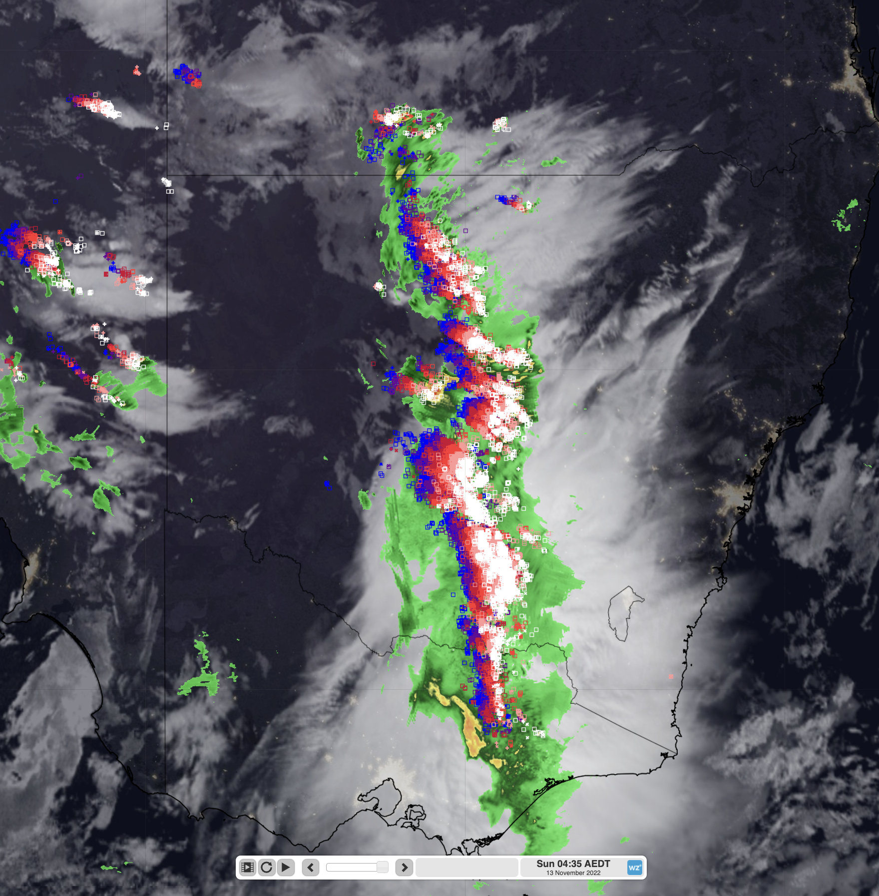
Last night, a line of severe thunderstorms built up in eastern South Australia and proceeded to run in a nearly unbroken line across inland New South Wales and northern Victoria. These storms were fast moving, getting across most of the state and affecting the Tablelands and ACT, including Canberra this morning. We have already seen more than 300,000 lightning strikes until 8:30 this morning (an average of 10 strikes each second!). However, that is just the start of a potentially dangerous day for thunderstorms across eastern Australia.

Image: Pre-dawn satellite image with radar and lightning strikes in the last hour for NSW and northern Vic
Thunderstorms have already ripped through South Australia yesterday, causing very heavy rain and damaging wind gusts for many areas, and bubbled up across inland NSW through the afternoon. Within these storms, Adelaide Airport recorded a wind gust of 106 km/h, Moomba recorded a wind gust of 115 km/h and Grafton in NSW recorded a 93 km/h wind gust. This was in addition to almost 400,000 lightning strikes within 300 km of Adelaide yesterday that left more than 80,000 South Australians without power last night.
Today, the outbreak is expected to become much more widespread, with severe thunderstorms possible across inland NSW, southern Qld, and most of Vic, potentially including Melbourne. These storms bring the risk of destructive winds, large, possibly giant hail and heavy rainfall leading to flash flooding. As the afternoon continues, the risk will spread towards the coast, with a small chance of severe thunderstorms across Sydney in the afternoon.

Image: 24hr rainfall to Sun 13th 11pm AEDT with ECMWF
The extra danger attached to this burst of rainfall is that it will be once again, falling on saturated grounds of inland NSW and central and eastern Vic, contributing to moderate-to-major flooding for many of the major tributaries of the Murray-Darling system. There are already multiple warnings for severe weather out across the eastern states as the trough progresses east, with more likely to be issued as the day unfolds.
You can see in the images below that the culprit of the dangerous weather this weekend is the low pressure system in the Bight. The surface low is being supported up an upper level low, allowing vast amounts of tropical moisture to be dragged into an already unstable environment. There is also a cold pool of air over southeast Australia associated with this low. All of these factors, as well as the indicators we wrote about yesterday, combine to enhance the risk of severe thunderstorms across eastern Australia.

Image: Precipitable water in the atmosphere overlayed with 500 hPa heights and the surface low in the Bight at 2pm using ECMWF model
The risk doesn’t completely clear Australia by the end of the weekend either, with the trough still moving across the east coast of the country on Monday, continuing to bring thunderstorms across northeast NSW and eastern Qld. To add to the chaos, another pulse of cold air is likely to surge across southeast Australia during the week, bringing a few more days of winter to Vic.
Thunderstorms this afternoon and evening may be dangerous and pose a risk to lives, so it’s important to keep up to date with the latest warnings and information as the day unfolds here.
To find out more about DTN APAC thunderstorm forecasts, please email us at apac.sales@dtn.com.




