
A massive northwest cloudband is starting to spread rain across about 80 percent of Australia, including much-needed falls in drought-affected areas of southern Australia.
A cut-off low pressure system will interact with a stream of tropical moisture over the next four to five days, producing one of the biggest rainbands Australia has seen in recent years.
This hefty rain-bearing system crossed into WA on Wednesday, before spreading eastwards across Australia from Friday to Sunday. By the end of the week, rain from this system will have soaked large areas of every state and territory, affecting most, if not all, industries across Australia.
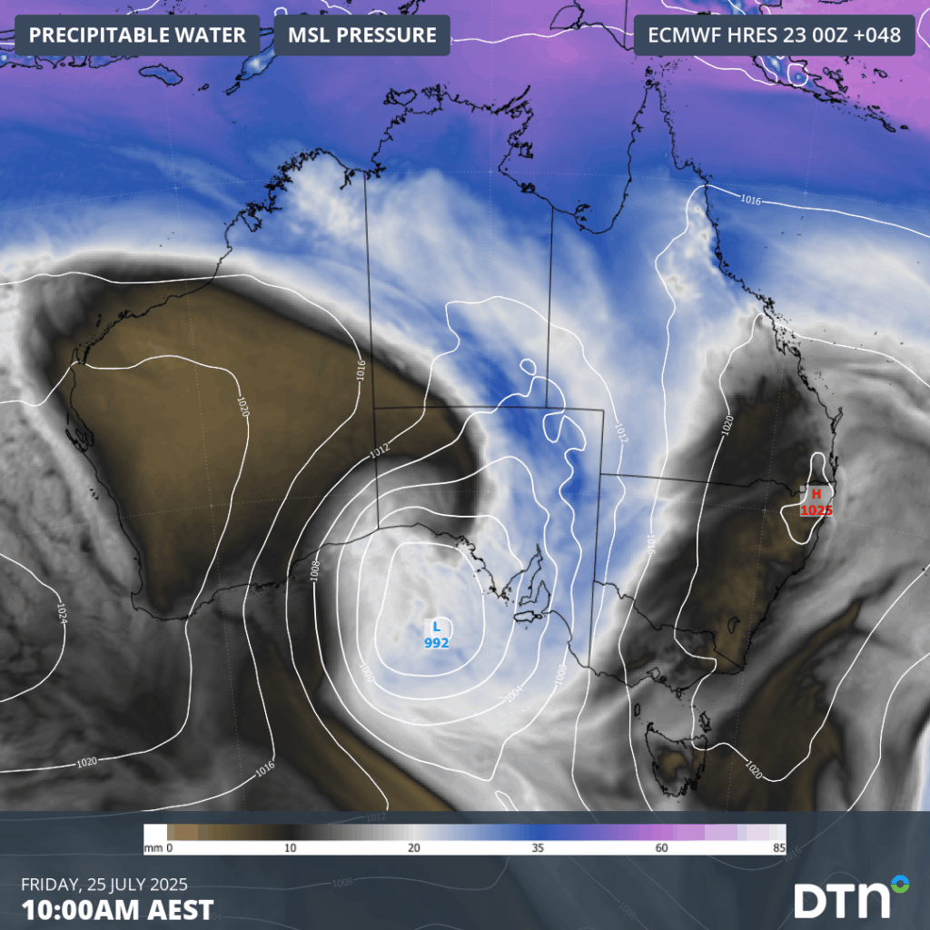
Image: Mean sea level pressure and precipitable water, showing a large low pressure system dragging a band of tropical across Australia.
This system will be notable for the widespread nature of its rain. While many areas in central, northern and eastern Australia have had decent of rain in recent months and years, parts of southern Australia have been abnormally dry for a long time. Fortunately, this week’s colossal cloudband will deliver rain to agricultural areas and industries that are trying to recover from record-breaking rainfall deficiencies over the last couple of years.
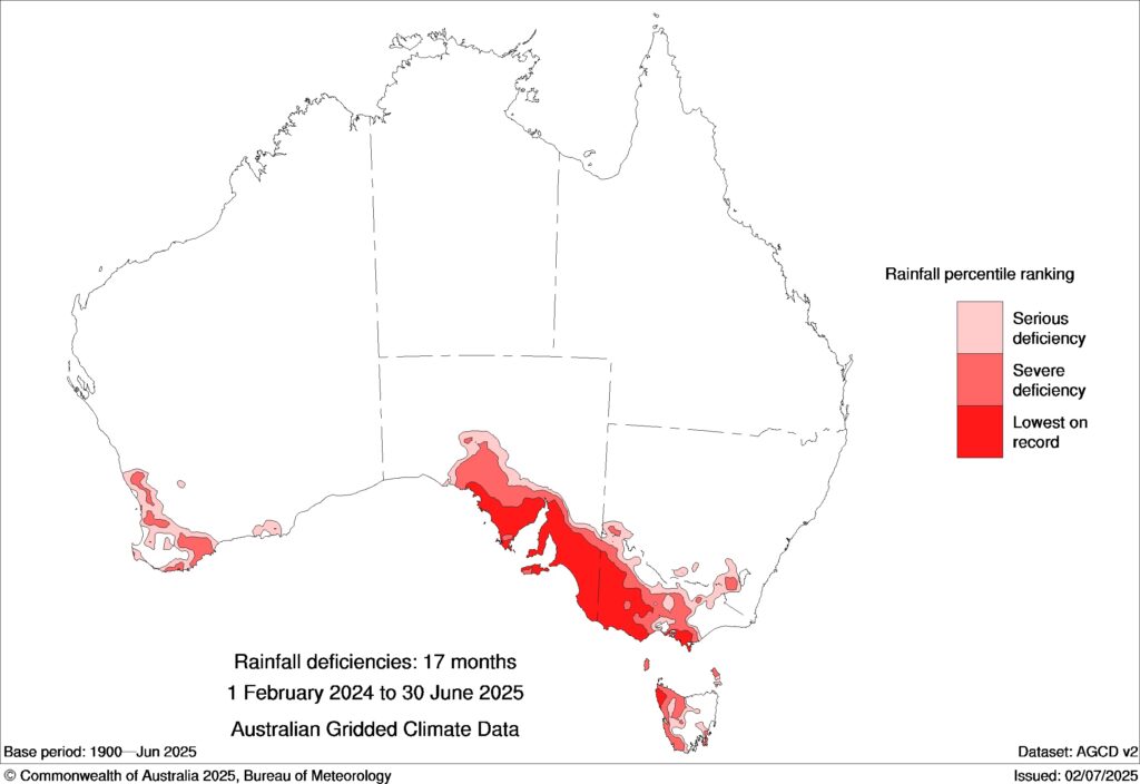
Image: Observes rainfall deficiencies during the 17-month period from February 2024 to June 2025. The red areas on the map show where rainfall was in the lowest 10 percent of historical records for this period, while the darkest red shading highlights places that had their lowest rainfall on record. Source: Bureau of Meteorology
Forecast models suggest that widespread falls of 10 to 30 mm are likely from the WA Interior down to southeastern Australia and up through inland areas of NSW and Queensland this week. Some areas will see more than this, with falls of 30 to 60 mm possible in parts of southern and eastern Australia, with heavier localised falls in some areas possibly causing disruptions to transport, mining and aviation industries.
There are also signs that another system could deliver follow-up rain across the southern half of Australia early next week. While this system isn’t likely to deliver as much rain as this week’s cloudband, it does have the potential to cause further decent falls in several states.
The map below shows how much rain is expected to fall across Australia during the seven days ending on Wednesday next week. Most of this rain will be caused by the system passing over Australia between Wednesday and Sunday this week.
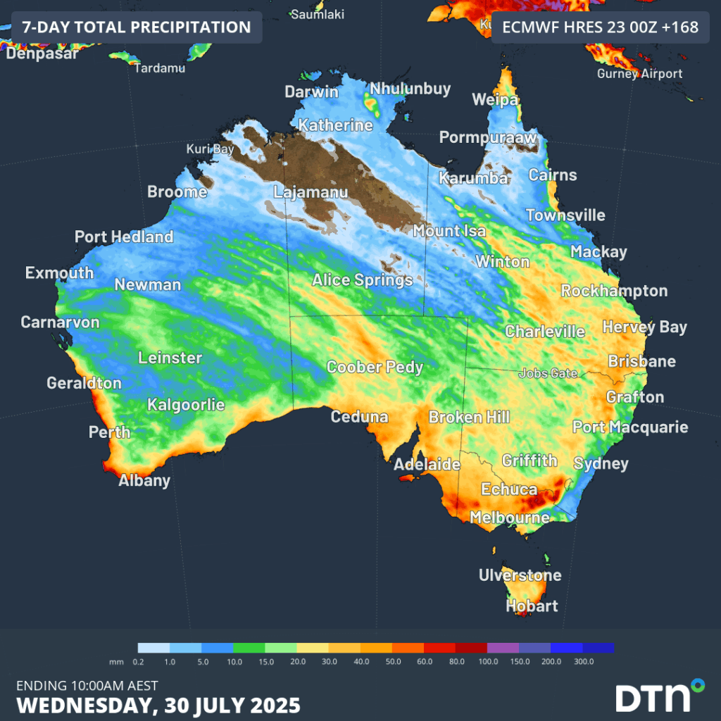
Image: Forecast accumulated rain during the seven days ending on Wednesday, July 30, 2025.
The coming week’s rain won’t be enough to completely make up for the large long-term rainfall deficiencies that have built up across southern Australia in recent years. However, it will be a big step in the right direction and some drought-affected areas could see the best rain they have had in months or years.
The DTN APAC Flood Risk System (FRS)
DTN APAC, delivers the Flood Risk System (FRS) to provide flood risk visibility. You can now easily visualise precipitation, and access rapid-update forecasting, across multiple sections of your site with the FRS geofenced alerting system. Gain a more precise determination with DTN APAC’s advanced geospatial technology creating hundreds of virtual ‘weather stations’ for each monitored section or culvert.
Rainfall is measured across each of your established catchments, with alerting calibrated to their individual thresholds. Alerts are raised when thresholds for any section are approaching or have been breached. This gives you targeted risk visibility to inform your assessment, operational response and emergency management.
The FRS can be integrated into your existing DTN APAC interface, or your own monitoring and control systems. Real-time monitoring of each catchment’s predefined thresholds is coupled with forecasting of rain, so you can provide your team with the most up-to-date information on whether conditions will ease, continue, or worsen.
Learn more about our large range of industry leading products and services or email us at sales.apac@dtn.com


