
Rain and thunderstorms will replace extreme heat over large areas of WA this week, with some places in the state’s north likely to see enough rain to officially mark the start of the wet season.
In Australia, the northern wet season is defined as the date after September 1 when at least 50 mm of rain has accumulated. This amount of rain is generally enough to stimulate plant growth after the dry season in northern Australia.
The map below shows that the 2023-24 northern rainfall onset occurred between September and December for large areas of Qld, the NT and the Kimberley in WA. However, as of late February, the wet season was yet to begin over parts of northwestern Australia.
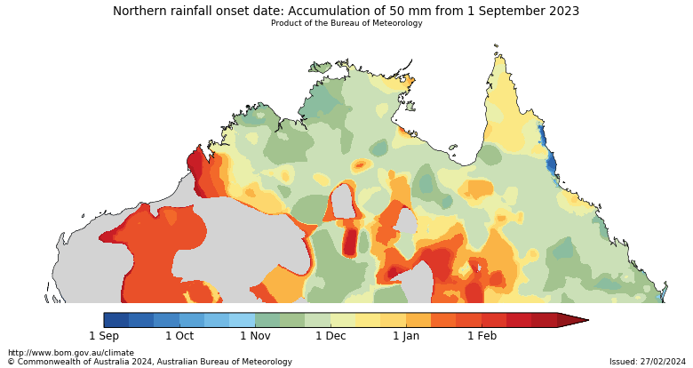
Image: Northern rainfall onset date observations for the 2023-24 wet season, as of February 27, 2024. Source: Bureau of Meteorology
While the 2023-24 wet season arrived early for some areas further east, many northern and interior areas of WA have been locked in a pattern of unusually dry and extremely hot weather since the start of this year.
At the end of February, Port Hedland had only received 25 mm of rain since the start of September, which is half of what it needs to kick off the wet season. In an average wet season, Port Hedland usually reaches 50 mm of accumulated rainfall by late-January.

Image: Port Hedland’s wet season rainfall to date, compared to its long-term wet season average.
WA just registered its hottest summer on record, with a mean temperature that was 1.90C above the 1961-1990 average. More locally, Carnarvon’s 49.9ºC towards the end of the season was the 2nd highest temperature ever recorded in Australia during February. This came as Perth registered seven days over 40ºC during February, the city’s most 40ºC days on record in a single calendar month.
This run of intense heat is finally coming to an end, with cloud starting to build over WA as tropical moisture feeds into a series of low pressure troughs.
Importantly, these rain-bearing troughs are expected to linger over the north and interior of WA for most at least a week thanks to blocking high pressure systems near southeastern Australia. This should help kick off the wet season in some areas of northern Australia.
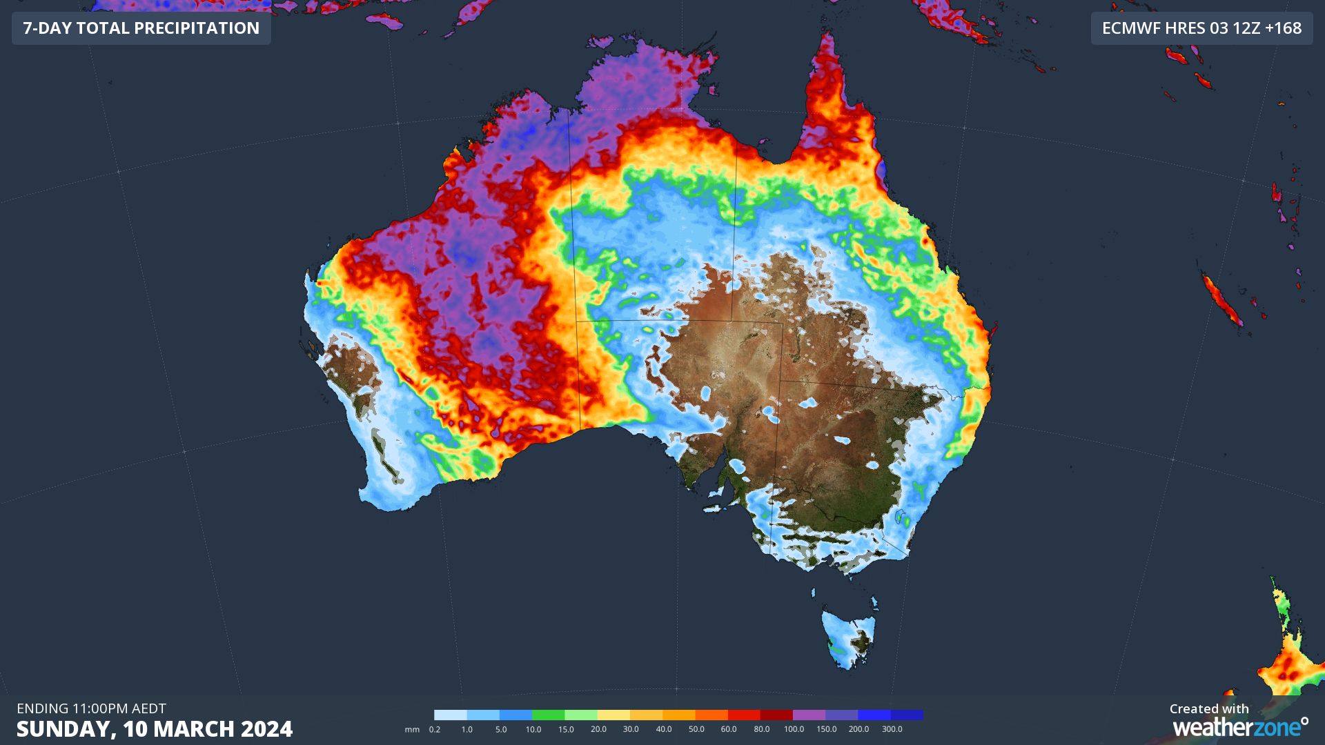
Image: Forecast accumulated rain this week, according to the ECMWF-HRES model.
This week’s rain and storms will erode the hot air mass that has plagued WA for the last few months.
The maps below show the daily maximum temperature forecasts from mid-February and on Thursday this week, highlighting the contrast in maximum temperatures.

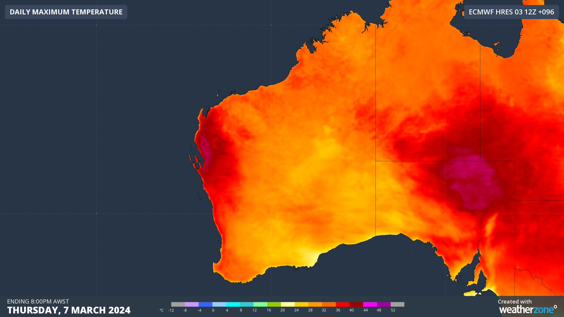
Images: Maximum temperature forecasts for February 18 (top) and March 7 (bottom), according to the ECMWF-HRES model.
While the cooler temperatures and wet weather are likely to be welcomed with open arms by many across WA this week, the rain will be heavy enough to cause flooding in some areas.
A flood watch has been issued for the state’s Salt Lake District and Nullarbor District Rivers and Sandy Desert, warning that significant river, creek, and stream rises are likely with heavy rainfall, with flooding and overland inundation possible.
Be sure to check the latest flood watches and warnings across WA over the next few weeks.
To find out more about our Mining Services and lightning alerting please email us at apac.sales@dtn.com.


