Prosper in a dynamic world
Search

Northwest cloudband to bring welcome rain

There’s a feature on this week’s weather charts which we haven’t seen for many months in Australia and which is a sign that winter is almost upon us: a northwest cloudband.

  • Northwest cloudbands are vast layers of cloud that flow over Australia from the northwest. Once fully developed, the cloudband stretches across the country like a sash from the northwest to the southeast.
  • Northwest cloudbands form when humid and warm tropical air over the Indian Ocean moves towards the southeast. As this warm and humid air moves further south, it rises over cooler air in the mid-latitudes and produces clouds.

READ MORE: WHAT IS A NORTHWEST CLOUDBAND?

Usually, northwest cloudbands produce rain – sometimes light, sometimes quite heavy – but usually rain of the steady, soaking variety rather than the bursts of showers which typically lash southern Australia from southwesterly cold fronts.
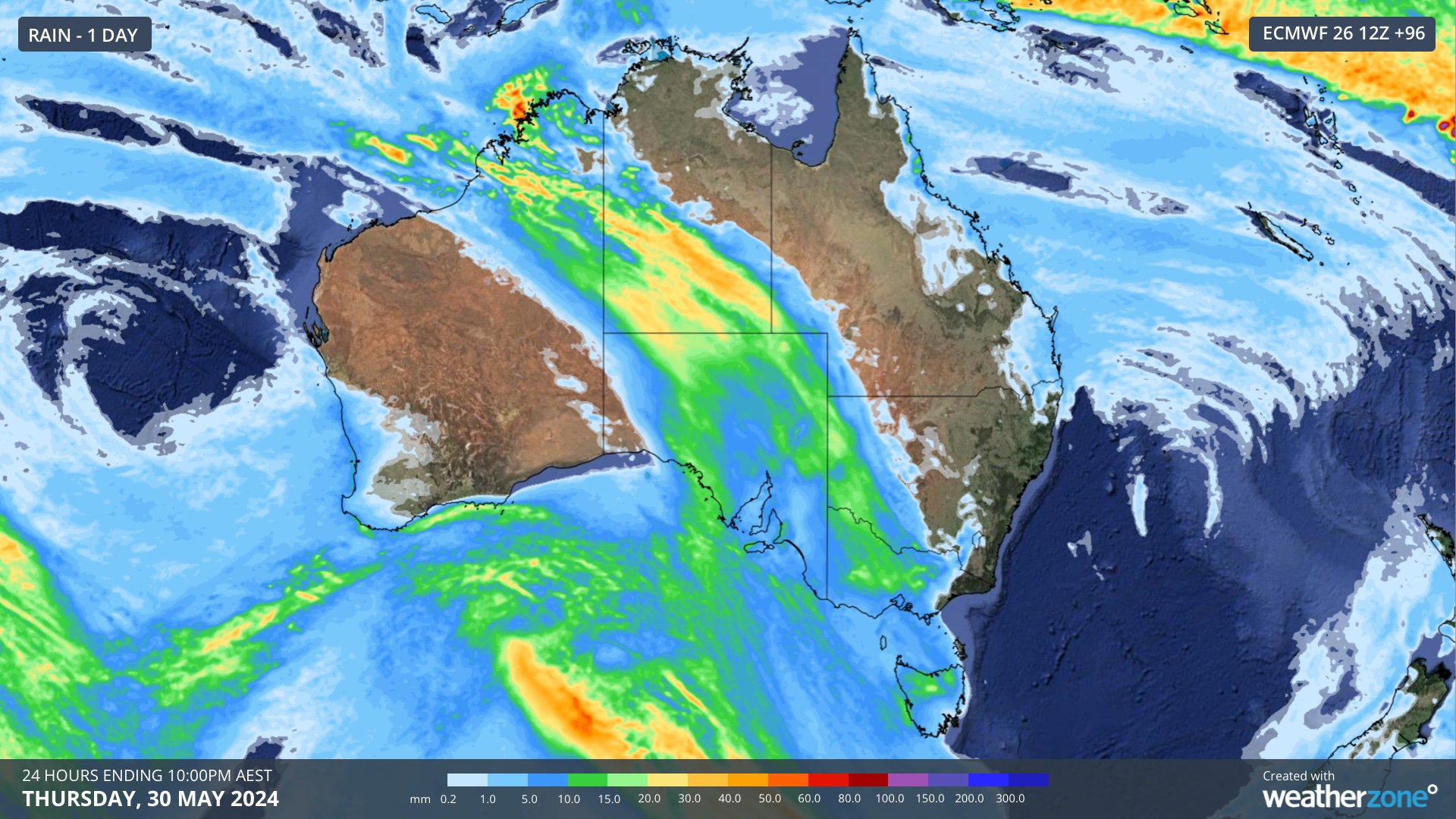
The chart above shows one prognosis for rain produced by this week’s northwest cloudband in the 24 hours to 10 pm this coming Thursday.

For parched parts of Western Australia, South Australia, Victoria and inland NSW, this is a welcome forecast.

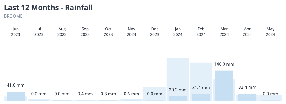
Coastal parts of northwest WA had very little rain during the wet season this year. Broome has recorded 228mm so far in 2024, 310mm short of average. Port Hedland has had a measly 35mm, compared to its January to May average of 246mm.
 

For now, it appears that at least some rain is coming to areas of SA, Vic, NSW and Tas that desperately need it and we’ll keep you updated on this system throughout the week.

Miningzone, by DTN APAC, is the only weather tracking and alerting solution purpose-built for the resources sector. To find out more, please visit our website or email us at apac.sales@dtn.com.

Latest news

Satisfy your weather obsession with these news headlines from around the nation, and the world.

DTN Dangerous Thunderstorm Alerts in action with severe thunderstorms disrupting Perth industries

Severe thunderstorms impacted southwest WA and the Perth region on Sunday, December 14, 2025, triggering Dangerous Thunderstorm Alerts (DTA) by DTN for industries and businesses in the region. DTN operates Dangerous Thunderstorm Alerts (DTA) which alert businesses and industries to thunderstorms based on intensity and movement. These alerts provide advanced notice of thunderstorms moving into […]

How Australian East Coast port and maritime operations could be disrupted by tropical cyclones over the next two weeks

Port and maritime operations across Australia’s East Coast could be disrupted by increased tropical cyclone activity in the Coral Sea and southwest Pacific Ocean over the next two weeks. Meteorologists reference a large selection of Numerical Weather Prediction (NWP) models to forecast weather. A number of these NWP models are forecasting the development of tropical […]

Extreme fire danger and severe heatwave conditions spreading across SA, Victoria and NSW

Hot, dry and windy weather causing elevated fire danger and severe heatwave conditions are sweeping across southeastern Australia over the next three days, driving high energy demand and disruption to operations. Clear skies associated a large and slow-moving high pressure system have allowed hot air to build up over parts of northern, western and central […]

Heightened bushfire risk during the 2025-26 summer for WA, Victoria and NSW in latest AFAC Outlook

The Australian and New Zealand Council for fire and emergency services (AFAC) identified western and southern WA, Victoria and inland NSW as key regions that are at risk of heightened bushfire risk this summer. Parts of Australia have experienced severe soil moisture and rainfall deficiencies over the past months and years, while high fuel loads […]