There are increasing signs that a tropical cyclone will develop offshore the WA coastline this week, possibly impacting the region over the weekend.
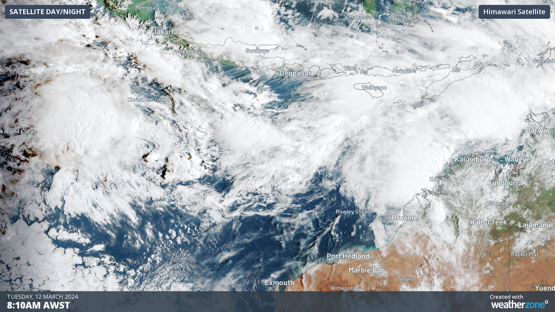
A tropical low designated 08U is 270 km southwest of Christmas Island and is expected to pass south of the Island this morning as it moves east towards the WA mainland.
Although the low is expected to pass well to the south of the Island, gale force winds are likely on Tuesday morning and afternoon, before easing tonight.
The map below shows the Bureau of Meteorology’s track map issued at Issued at 1:39 am CXT Tuesday 12 March 2024
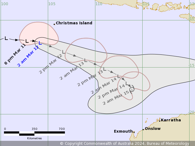
Image: Forecast track map issued by the Bureau of Meteorology Issued at 1:39 am CXT Tuesday 12 March 2024. A more recent track map may be available. Source: Bureau of Meteorology
The track map above shows the tropical low (08U) could develop into a category one tropical cyclone in the early hours of Friday morning as it continues to move east towards the Pilbara.
There is still some uncertainty on the strength and track of the system over the weekend, however at this stage models are indicating it will remain offshore. While it is most likely to remain offshore, strong winds, heavy rain and rough seas could still be felt over the weekend in the Pilbara.
The European Centre for Medium-Range Weather Forecasts (ECMWF) model shows a wide range of possibilities later next week, with tropical cyclone strike probabilities of 30 to 40 percent around the Pilbara coastline on Sunday, March 17.
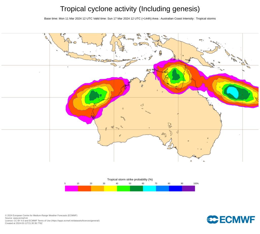
Image: ECMWF strike probability for 10pm AEST on Sunday, March 17. The strike probability is the probability that a tropical cyclone will pass within a 300 km radius from a given location and within a time window of 48 hours. Source: ECMWF
The strike map above also shows two other tropical lows in the Australian waters by Sunday, March 17, one in the Gulf of Carpentaria and the other in the Coral Sea.
The tropical lows are forming in the monsoon trough which is sitting over the northern Australian waters.
The tropical low designated 09U is likely to form to the northwest of Kimberley on Tuesday or Wednesday. The system is then likely to cross the western Top end on Wednesday or Thursday as a tropical low before moving into the Gulf of Carpentaria. When it moves into the Gulf of Carpentaria later in the week there is a low chance of it developing into a tropical cyclone.
Another low, designated 10U, has developed to the north of the Gulf of Carpentaria and should move east into the Coral Sea on Thursday or Friday. As it moves over the Coral Sea there is a low chance it could develop into a tropical cyclone. The system is then expected to continue offshore later in the week.
Anyone living in northern Australia should pay close attention to the latest tropical cyclone advisories and weather warnings over the next couple of weeks.


