
A brief burst of heavy rain is likely to cause flash flooding along Queensland’s central coast on Thursday.
A coastal trough being fed by a deep layer of moisture-laden winds coming off the Coral Sea will cause heavy rain over Qld’s central coast and adjacent inland on Wednesday night into Thursday. There also signs that a small low pressure system could form near the coast, which would further enhance rainfall in the region if it forms.
The rain from this system is expected to be brief but intense, likely brining 100 to 200 mm between Wednesday afternoon and Thursday night, with isolated falls possibly exceeding 300 mm. If this much rain does fall, it would easily be enough to cause localised flash flooding.
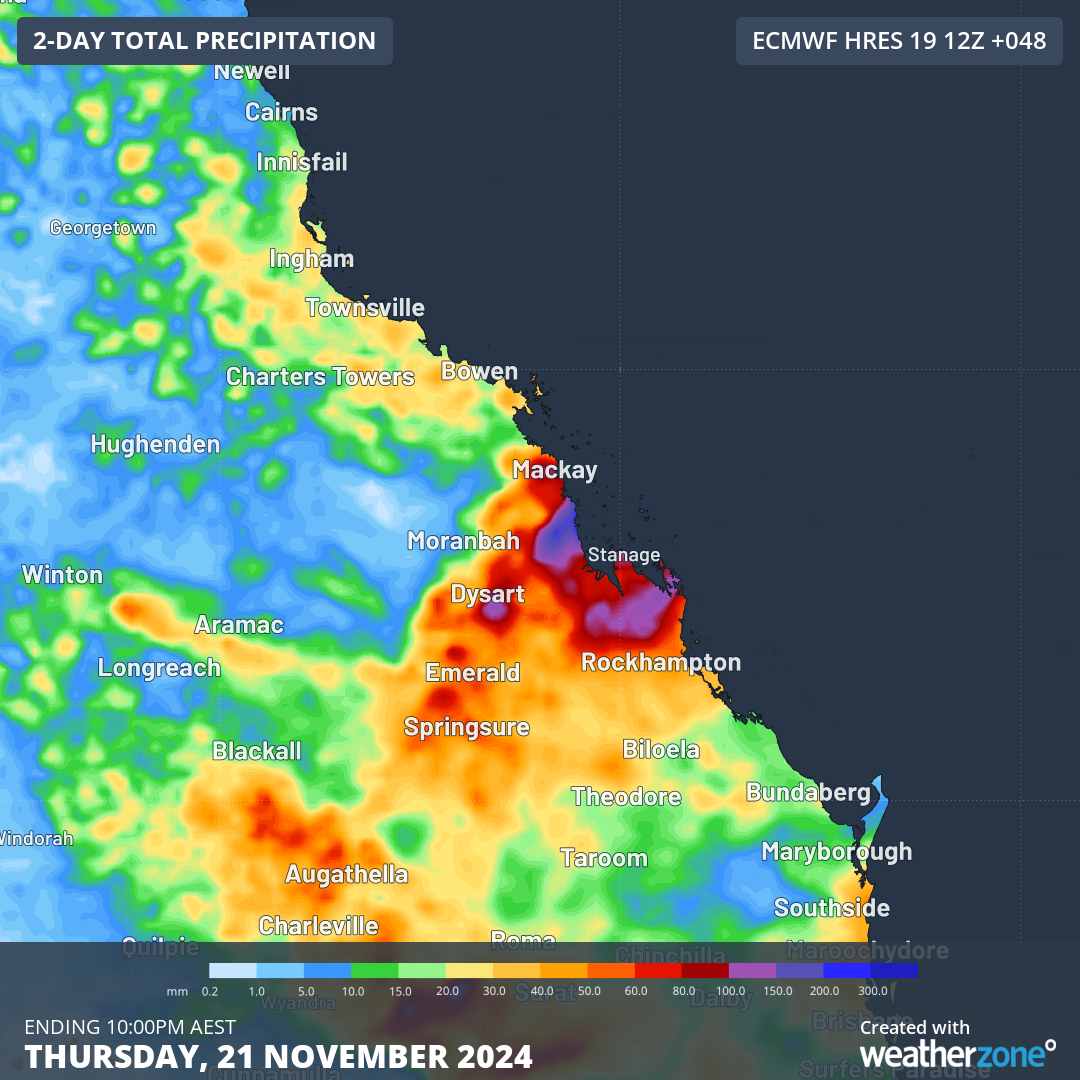
Image: Forecast accumulated rain over central Qld during the 48 hours ending at 10pm AEST on Thursday, November 21, 2024.
It’s worth pointing out that there is some uncertainty regarding this event. It’s clear that a period of heavy rain will develop during Wednesday night and on Thursday. However, it’s uncertain exactly where and how much rain will fall, so be sure to keep up to date with the latest forecasts and warnings during the next 48 hours.
In addition to the rain that’s about to soak Qld’s central coast, areas of rain and thunderstorms will also impact other parts of the state on Wednesday and Thursday.
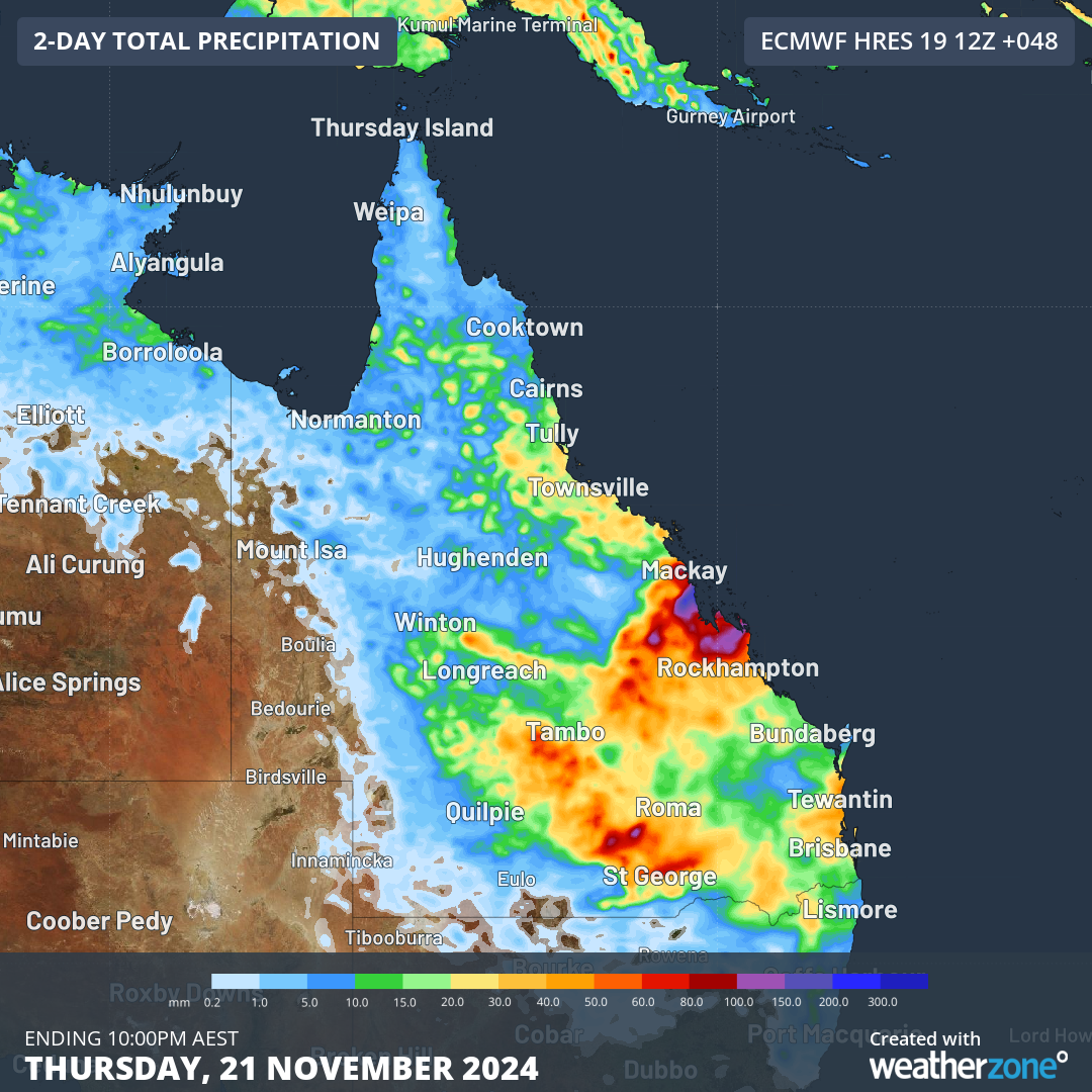
Image: Forecast accumulated rain over central Qld during the 48 hours ending at 10pm AEST on Thursday, November 21, 2024.
This wet and stormy weather is being fuelled by persistent moisture-laden air coming from the Coral Sea, where sea surface temperatures in some areas are running around 1°C warmer than average for this time of year. This extra warmth is enhancing evaporation and pumping more moisture into the atmosphere.
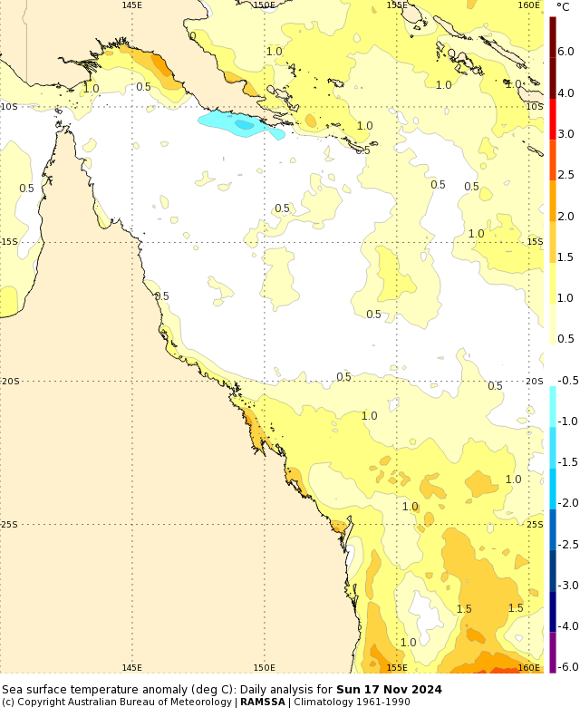
Image: Sea surface temperature anomalies in the Coral Sea on November 17, 2024. Source: Bureau of Meteorology
Rain should ease over central Qld on Friday, although showers and some thunderstorms will continue over the state’s north and east into the weekend.
DTN APAC offers a comprehensive suite of services, refined through years of collaboration with the marine, ports and offshore industries, to optimise the safety and efficiency of your operations.
We work with you to understand your intrinsic operational challenges and customise high-precision forecasting, metocean and aviation services to your exact location and operational scope.
When working offshore, our solutions can underpin planning and safe execution for offshore oil and gas enterprises and wind farms. Our data can support your exploration, development, rig moving, shuttle tanker operations, and production and decommissioning phases. Whether your crews are on-site, being transported to shore, or diving to perform maintenance, we deliver tailored weather risk briefings to ensure you choose the optimal time to proceed.
Weatherzone’s trusted nowcasting and forecasting system, OpticastTM, allows you to rapidly respond to changing conditions offshore, en route and in port. We take your port topography and berth orientation into account, ensuring site-specific forecasts. For offshore oil & gas, wind farms, ports and logistics, we have your weather situational awareness covered, no matter where you are. We deliver real-time severe weather and lightning alerts to your team via your integrated dashboard: Portzone, and our Weatherguard app.
Weatherzone’s Total Lightning Network (TLN) ensures you avoid hours of unnecessary downtime by providing the most accurate technology in lightning detection and alerting. Safeguard your teams and assets with lighting and Dangerous Thunderstorm Alerts (DTAs), customised to your existing parameters and delivered in real-time across all devices in your network. You gain full spatial awareness of developing severe weather systems, allowing you to plan ahead and, where needed, execute your shutdown and evacuation procedures.
With extreme conditions slowing production and affecting infrastructure, safety and transport, trust us to deliver Australia’s most precise weather data and tailored insight, giving you decisive confidence when it’s most needed. For more information please visit our website or email us at sales.apac@dtn.com.
Headline image credit: iStock / Smyk_


