
Darwin’s latest monsoon on record is finally arriving on Friday, bringing heavy rain, thunderstorms with it and a higher risk of tropical cyclone development in the next week or so.
The monsoon refers to the seasonal reversal of the wind pattern over northern Australia, where the dry east to southeasterly winds that dominate for much of the year are replaced by west to northwesterly winds. These monsoonal winds carry vast amounts of moisture laden air from the Maritime Continent and surrounding oceans towards northern Australia, typically resulting in periods of increased cloud and rainfall.
The monsoon usually fluctuates between active and inactive phases over northern Australia between November and April. However, its onset date – the first time it arrives in each wet season – can vary quite a lot from year to year.
While the monsoon has already brought heavy rain to some areas in northern Australia this in the last few weeks, it has not yet arrived in Darwin. In fact, this is now the latest monsoon onset on record for Darwin, easily beating the previous record of January 25 from the 1972-73 wet season.
The absence of the monsoon in recent weeks, combined with onshore winds and above average sea surface temperatures near the Top End, have caused some oppressive overnight temperatures in Darwin.
The last half of January featured four nights where the temperature stayed above 27°C in Darwin, which is more than 2°C above average. Earlier this week, the temperature only dipped to a low of 30.0°C on Monday morning, which was Darwin Airport’s highest February minimum temperature on record.
Forecast models are showing clear signs that a monsoon trough will form to the south of Darwin by Friday, which will allow the monsoon west to northwesterly winds to flow over Darwin and mark the monsoon onset for the 2024-25 wet season.
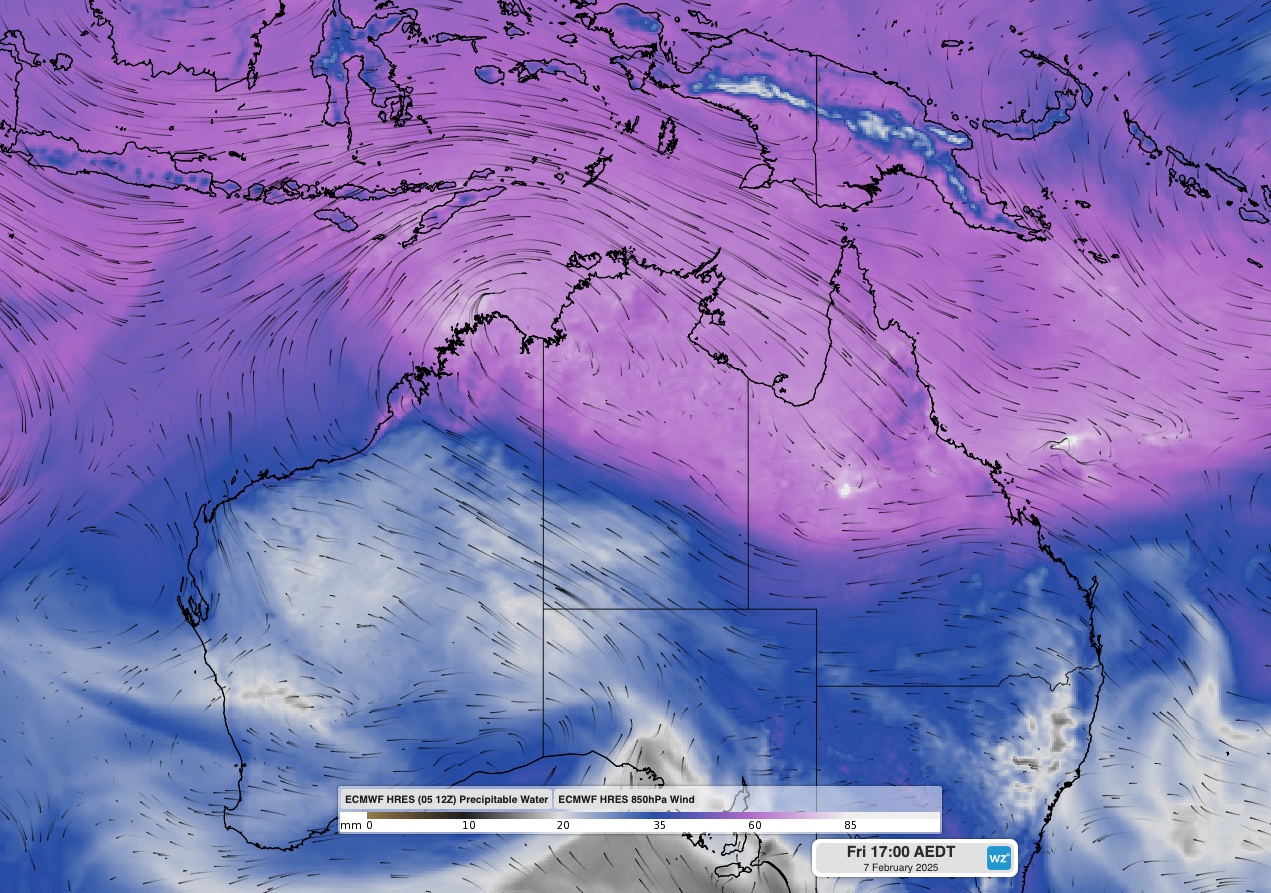
Image: Modelled precipitable water and 850hPa winds, showing moisture-laden northwesterly winds flowing over the Top End and northern Qld on Friday.
This will cause cloud and rain to increase over Darwin and other areas of northern Australia, including a broad area of northern Qld and some northern parts of WA. This rain may cause further flooding in areas of northern Qld that are still reeling from the immense rainfall totals that occurred over the past couple of weeks.
Active phases of the monsoon can also enhance the likelihood of tropical lows and tropical cyclones near Australia.
Forecast models suggest that two tropical lows could form in the Australian region this weekend, one near the Kimberley coast and the other over the Coral Sea to the east of Qld. At this stage, these systems only have a low chance of becoming tropical cyclones in the next seven days, although they are worth watching closely in the coming days.
As the climate delivers increasingly severe weather events, their potential to impact your business operations grows.
DTN APAC, specialises in industry-leading forecast, alerting and threat analysis of tropical cyclones, offering you expert, customised solutions when the weather turns wild.
Providing rapid-update forecast information, we alert you to any low-pressure system gaining power within your region and, unlike other providers, can track its development out to 7 days. This gives you the time to prepare and safeguard your staff, sites and assets.
You will have the most precise weather intelligence charting rainfall, wind speeds and potential storm surges to help you make critical decisions quickly. Whether it’s adjusting key work schedules, protecting your staff or securing your site, we have the alerting capability to keep you steps ahead of the storm.
We will support you, 24/7, keeping you informed and making your critical decisions easier. For more information contact us at sales.apac@dtn.com
Thumbnail:iStock / Armastas




