Mining blasting is the quickest, easiest, and cheapest way to remove rock and maximise production in open cut mining. However, there are many challenges that mine superintendents and blast managers face when considering a blast. Minimising environmental impacts and ensuring health and safety of miners is constantly a challenge when blasting for the superintendents.
Information on weather conditions is paramount to minimise these risks to not only the mine site but also surrounding locations. Rainfall, wind, and inversion layers (the depth of atmospheric mixing) play a huge role in the amount of dust and fumes and where they may travel.
Weatherzone’s blast dispersion model allows blasting managers to gain a clear understanding of a blast events expected trajectory and pollutant concentrations (figure 1). Of course, avoiding plumes from reaching nearby communities is in the forefront of blast superintendents minds, when conducting blasts.
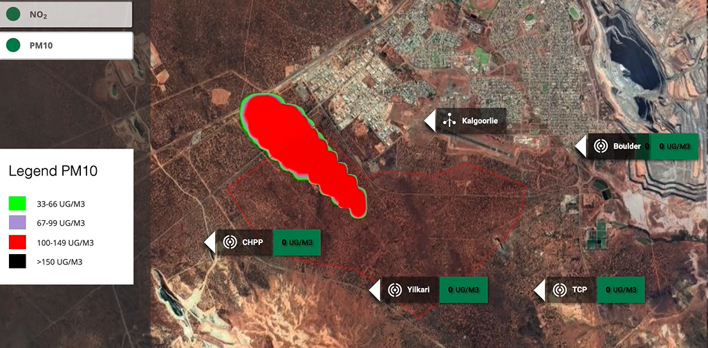
Figure 1: Weatherzone’s blast dispersion model demonstration, showing no exceedance in pollutants at sensors (green boxes at sensors)
Weatherzone’s blast dispersion model assists the superintendents on making smarter and more informed decisions on when is best to blast.
The model considers your geofenced mine, elevation above sea level, the azimuth, the amount of explosive for the blast and any weather stations and sensitive receivers in your setup.
It then simulates local weather conditions such as wind and the inversion layer, which can determine how far the blast plume is likely to travel. Opticast our model learns and adapts the forecast based on your current observations at your site such as wind, ensuring accurate plume forecasting.
The model allows you to monitor both NO2 and PM10 pollutants and their concentrations over the 30-minute period following blast time. The concentrations of the pollutants are shown in one- or two-minute intervals in the PDF report that is generated.
The model allows you to add 3 concurrent blasts and 5 simulation times. This enables the superintendents to find the best blast window, without having to rerun the model each time.
The monitoring stations nearby the mine site will turn red if they are expected to exceed given thresholds during the simulation.
Of course, blast plumes are not the only risk to nearby communities. Inversion layer forecasting is also important as it can determine the level of noise or vibrations that will occur after detonation.
Moisture or rainfall can hinder blast detonation as well as creating blast clouds that are brown, red or orange, which are very noticeable to people nearby. Weatherzone provides accurate rainfall forecasting to mine sites to help minimise this risk.
For more information, please contact us at apac.sales@dtn.com.


