Dynamic springtime weather with widespread severe thunderstorms, heatwave conditions and elevated fire danger affect many Australian industries, including mining, emergency services and transport.
![]()
Image: Widespread thunderstorms across eastern WA, and bushfire smoke across northern Queensland and the eastern NT on Thursday, October 23, 2025.
Scattered to widespread severe thunderstorms spread east
As seen in the satellite imagery above, dynamic weather is already affecting broad parts of Australia’s north and interior. Thunderstorms over WA and the interior brought 5-15mm of rain to the few rain gauges scattered over the remote outback region, including:
- 15mm at Giles, WA (wettest October day in eight years)
- 14mm at Wulungurru, NT (wettest October day in eight years)
- 6mm at Yulara Ap, NT (wettest October day in three years)
Heavier rainfall is likely to have fallen in between rain gauges, but in such remote areas, transport routes and mining sites need to rely on remote sensing data, or install their own observation sensors to evaluate the risk of flash flooding across the landscape.
Nearly 400,000 lightning strikes have been recorded since early Thursday, with much more lightning activity expected across the coming weekend.
Thunderstorms activity over WA’s interior, and SA’s west on Friday will spread east into SA on Saturday. Thunderstorms risk being severe, bringing the risk of heavy rainfall quickly deteriorating road conditions, as well as damaging wind gusts, bringing disruptions to vital transport routes and remote mining outposts.
Severe thunderstorm risk diminishes slightly further east on Sunday, but heavy rainfall remains a risk for Victoria and Queensland over the weekend.
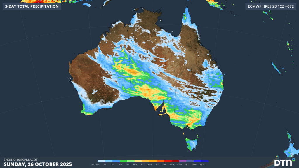
Image: Forecast rainfall accumulations over the next three days as a result of thunderstorm outbreaks and areas of heavy rainfall.
Elevated fire risk and heatwave conditions for the NT and Queensland
Satellite imagery below shows widespread areas of bushfire smoke from a number of active fires across Queensland’s north and the NT’s east.
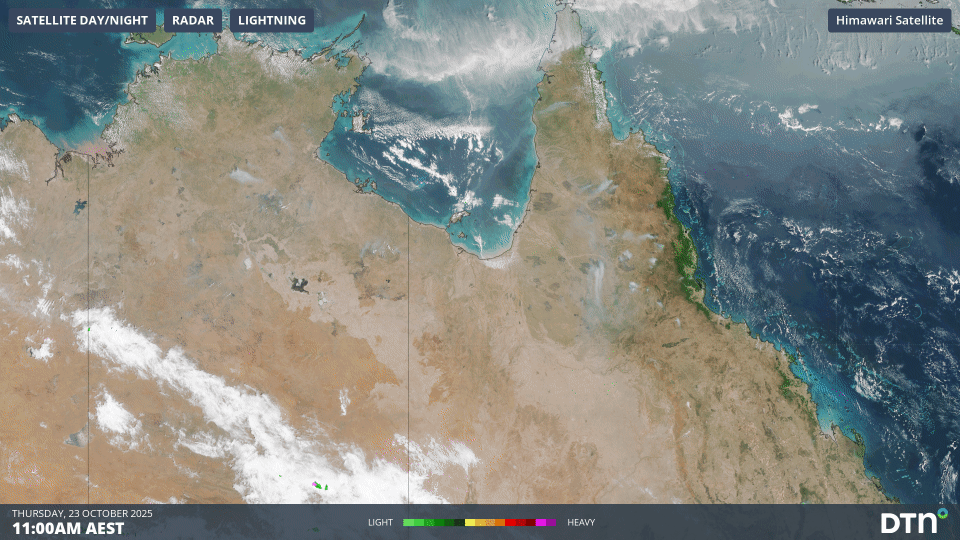
Image: Satellite imagery of bushfire smoke over Queensland and the NT on Thursday, October 23, 2025.
As rural fire services battle to contain already ongoing fires, emergency services across the region will also have to manage intensifying heatwave conditions and worsening fire weather.
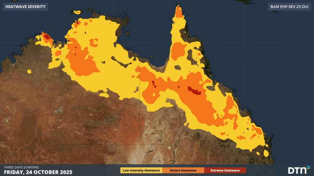
Image: Severe-to-Extreme Heatwave conditions forecast between Friday and Sunday, October 24-26, 2025, over broad parts of the northern NT and Queensland’s north and inland.
Intense heatwave conditions are expected across many of the fire grounds with consecutive days reaching the low 40s hazardous for personnel and outdoor workers.
Hot, dry and windy conditions will maintain high fire danger ratings across the coming days. A cooling southerly change moving up NSW on Monday, and extending into Queensland on Tuesday will bring cooler temperatures and more manageable conditions next week. This southerly change will however bring a sudden wind change that can cause erratic fire behaviour, potentially worsening fire conditions before improving.
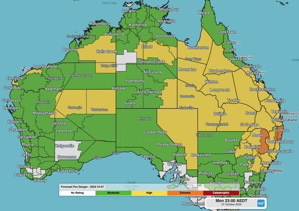
Image: Fire Danger Ratings across Australia on Monday, October 27, 2025.
How DTN APAC is helping remote mining, transport, fire services and agricultural industries with advanced weather intelligence, remote sensing and now-casting solutions during the severe weather season
Australia is a vast country with densely populated coastal areas across the south and east, and millions of square kilometres of sparsely populated and rich in resources elsewhere. Typical radar coverage extends to a radius of about 200km, however mountains, trees and towers can restrict this optimal coverage range. Even with over 60 radar sites operating across Australia, vast expanses of the outback and WA remain outside of this traditional radar coverage, as seen in the left image below.
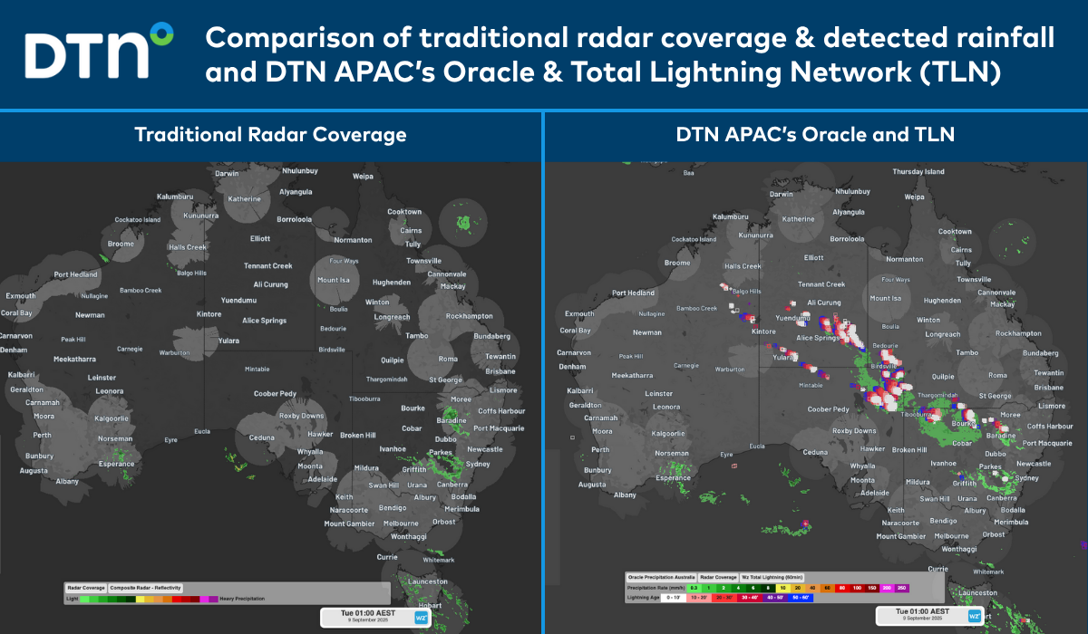
Image: Comparison of traditional radar coverage and detected rainfall (left), and DTN’s Oracle and TLN (right), across Australia at 1am AEST on Tuesday, September 9, 2025.
The image on the right shows DTN’s Oracle rainfall and Total Lightning Network detecting a vast area of rain and thunderstorms that would have been missed by traditional detection methods.
DTN Oracle
High-Resolution Modelling
Oracle is a satellite-derived, gridded nowcasting system. It forecasts out to 3 hours at a 1-2km resolution, and rapid updates every 5 minutes. With this enhanced forecasting detail, Oracle has the upper hand over 9-12km resolution models when capturing temperature, lightning, cloud cover, wind and rainfall. This ensures that no matter where you are in Australia, you will have access to precision nowcasting and forecasting that can rapidly inform your critical business decisions.
Greater Situational Awareness
Working in conjunction with DTN APAC’s Stormtracker GIS system, Oracle provides full situational awareness of any severe weather event that presents risk to your business. Short-term forecasting and severe weather alerts enable you to foresee the intensity and duration of events, so you can prioritise the safety and preparation of your staff and assets.
Whatever the weather, we provide the insights to help keep you and your team safe, productive and profitable.
DTN Total Lightning Network
Our Total Lightning Network is the intelligent lightning solution that goes above and beyond to alert lightning and increase your lead time before the storm hits.
We utilise a vast global sensor network, created with our partner Earth Networks. Over 1200 sensors in 40+ countries provide a worldwide view of both intra-cloud (IC) and cloud-to-ground (CG) lightning strikes, enabling businesses to plan and respond with the most precise insight available. Our system can detect and calculate strike locations with incredible accuracy, offering real-time lightning mapping for a comprehensive view of storm activity.
Offering unsurpassed accuracy, with real-time sensing to <200m, we integrate with your existing systems to keep your enterprise operating within your defined severe weather thresholds. Our technology also helps monitor radiation from electrical discharges and ensures every lightning flash is accounted for.
Leave nothing to chance. Be confident working outdoors with the most sophisticated lightning alerting system, delivering intelligence to any device across your business network. Whether you need a personal lightning alerting tool for individual safety or enterprise-wide monitoring, our solution is designed to emit timely alerts and protect your operations.
How DTN APAC Services Fire-Prone Outdoor Industries
Working in often challenging conditions across high-risk outdoor operations including forestry, emergency services, mining, rail, and utilities, our consolidated weather services ensure full situational awareness for you and your team.
DTN APAC serves fire-prone outdoor industries, delivering trusted weather data and severe weather alerting to maintain safety, protect your assets and underpin your operational planning.
Reinforce your Prevention, Preparedness, Response and Recovery (PPRR) efforts with our tailored services.
Prevention: Utilise our seasonal outlooks and daily forecasting to identify and implement prevention measures. Understand the climate risks affecting your operations. Calculate optimal timing for maintenance activities, vegetation management, and scheduled shutdowns.
Preparedness: Gain understanding of bushfire risk in the days, weeks and months leading up to peak fire season. Use DTN APAC’s seasonal outlooks and 14-day forecasting to plan workforce deployment, equipment positioning, and preventative operations such as controlled burns or asset maintenance.
Response: We deliver fire danger forecasts and provide nowcasting and forecasting of severe weather events, including thunderstorm/lightning detection and alerting, to give you full situational awareness of emergency conditions likely to impact your operations and infrastructure.
Recovery: Assess the weather risks affecting post-incident recovery and restoration processes. Utilise post-event analysis reports to support insurance claims, evaluate operational response effectiveness, and inform future risk management strategies.
We work to bring you full situational awareness so you can mitigate risk, ensure workforce safety, and maintain operational continuity across your outdoor assets.
See our Case Study on how Tasmania Fire Service (TFS) improved lightning detection and continued optimising preparations for challenging fire seasons ahead with DTN APAC’s full suite of solutions.
Learn more about our large range of industry leading products and services or email us at sales.apac@dtn.com


