A tropical cyclone could form by early next week, with monsoon winds and tropical lows triggering the wet season and potentially impacting northern Australian businesses.
The animation below shows widespread cloud around northern Australia on Friday. Within these vast areas of cloud are several areas of low pressure that have the potential to deepen and become more consolidated tropical lows over the coming days.
Image: Enhanced water vapour satellite images showing abundant cloud near northern Australia on Friday.
One area of low pressure has already caused torrential rain in parts of northern Qld this week, with close to one metre of rain falling in just three days. More heavy rain is expected to fall over northern Qld this weekend and early next week as the low pressure system continues to feed on a seemingly endless supply of tropical moisture.
The Bureau of Meteorology is currently tracking six separate areas of low pressure in the Australian tropical region, all of which have potential to produce tropical lows or tropical cyclones in the coming week.
The most likely area for tropical cyclone formation in the next few days will be over the Indian Ocean to the south of Christmas Island. The Bureau gives this region a high chance (55%) of producing a tropical cyclone between Monday and Thursday. The BoM also gives a moderate chance of tropical cyclone development off the northwest coast of WA and over the Coral Sea early to mid-next week.
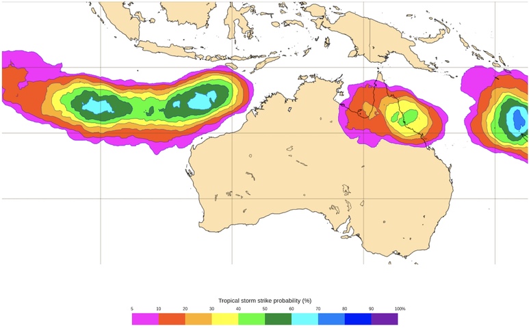
Other international forecast modelling supports the heightened risk of tropical cyclone development early next week. An ensemble model from the European Centre for Medium-Range Weather Forecasts (ECMWF) gives a 60-70% chance of tropical cyclone formation in the Australian region by early next week.
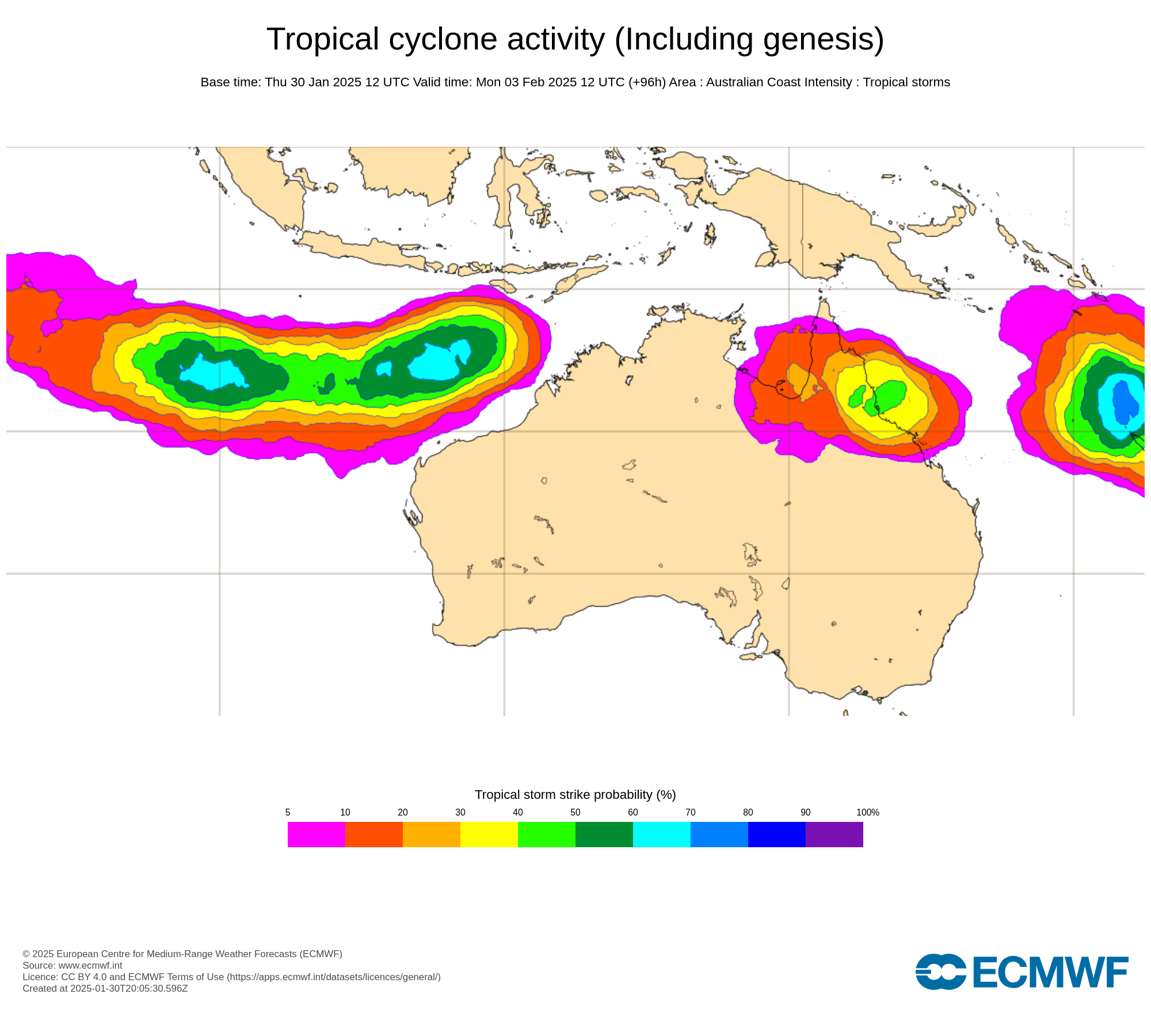
Image: Tropical cyclone strike probability, showing the likelihood that a tropical cyclone will be located within a 300 km radius from a given location and within a time window of 48 hours. Source: ECMWF
At this stage, there are no clear signs that any tropical cyclones will make landfall over the Australian mainland in the coming week. However, there is currently a high degree of uncertainty regarding the location, strength and movement of these tropical lows or cyclones, so the situation may change in the coming days.
Prior to this week, Australia’s northern wet season had been slow to get going in the absence of the monsoon trough in recent months. As January draws to a close, Darwin is still waiting for the monsoon to arrive in earnest in what is now going to be the city’s latest monsoon onset on record.
However, heavier rain has hit northern Qld this week and more characteristic wet season rainfall should affect some other areas of northern Australia next week as well.
DTN APAC gives you a comprehensive tropical cyclone service that helps your enterprise prepare for the worst in the best possible way.
As the climate delivers increasingly severe weather events, their potential to impact your business operations grows.
DTN APAC, specialises in industry-leading forecast, alerting and threat analysis of tropical cyclones, offering you expert, customised solutions when the weather turns wild.
Providing rapid-update forecast information, we alert you to any low-pressure system gaining power within your region and, unlike other providers, can track its development out to 7 days. This gives you the time to prepare and safeguard your staff, sites and assets.
You will have the most precise weather intelligence charting rainfall, wind speeds and potential storm surges to help you make critical decisions quickly. Whether it’s adjusting key work schedules, protecting your staff or securing your site, we have the alerting capability to keep you steps ahead of the storm.
We will support you, 24/7, keeping you informed and making your critical decisions easier. For more information contact us at sales.apac@dtn.com


