Unusually forceful waves are assaulting the Sydney coastline today. However, these waves have a peculiar quirk: they are not that big. So how can they be considered ‘powerful’?
Waves this morning have been measured peaking at 4.5m off the Sydney Coast, with the highest third of waves (the significant wave height) averaging about 2.3m. While these heights are solid, they aren’t historically high. Even just over this past weekend, waves with a significant wave height of 3.5m, and a max height peaking at 7.2m were detected.
These waves can be seen below in the blue and green Lines.
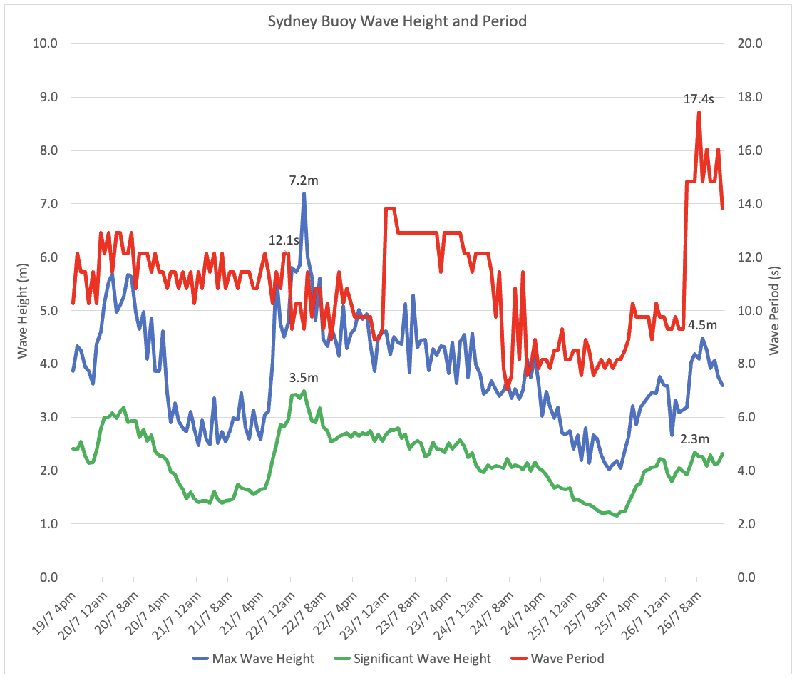
Image: Data from the Manly Hydraulics Laboratory Sydney Buoy. Blue is maximum wave height, green is Significant Wave Height (both left axis), and red is Wave Period (right axis).
The big difference with Wednesday’s waves is what is happening with the red line in the graph: the wave period. Wave period is the time it takes for the top of one wave to pass and the next to arrive. The longer the period, the further spaced apart the waves are.
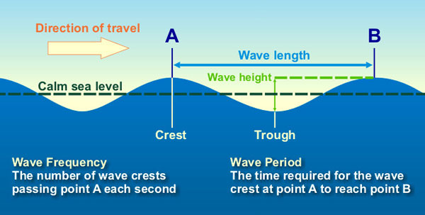
Image: Diagram explaining different parts of ocean waves. Source: NOAA
The danger from high period waves is how the energy of the swell is split up. Wave energy of a swell is determined by its wave height, the higher the wave, the more energetic it is. However, with a high period swell, there are less waves transporting the energy across the water. The consequence is that each individual wave carries more energy and is stronger than in a low period swell. With each wave more powerful, ferries and ships take more of an impact from each wave, while ports often see more movement from anchored vessels.
Swells with such a high period originate from far away, typically from powerful cold fronts in the Southern Ocean, Tasman Lows near New Zealand or Tropical Cyclones in the Coral Sea. Like on Wednesday, the vast distance from these storms means that Sydney can often have a bright sunny day when these waves arrive, deceptively different from what the beach conditions would normally be.
Wednesday mornings waves reached an impressive 17.4 second delay between each wave, with similar wave periods being recorded on the South Coast and Mid North Coast of NSW. Values this high are uncommon, only having a 1.2% change of occurring in July. These waves originated deep in the Southern Ocean from a low and cold front near Macquarie Island, about halfway from Hobart to Antarctica.
The high period swells are likely to continue for at least the next few days, slowly decreasing as the source low is already long gone. As of 4pm, the hazardous surf warning was still in effect, so it’s best to check the conditions before you head out.
DTN APAC has all of your marine forecasts covered, from our lightning detection (that does cover a significant distance off the coast), our Opticast automated forecast system, and a highly qualified meteorologist team. To find out more, please visit our website or email apac.sales@dtn.com.


