Heavy rain, strong winds and powerful waves are on the cards from this weekend for eastern NSW businesses and industries as an intense complex low rapidly intensifies.
Rapidly intensifying low pressure system near northeastern NSW
An area of low pressure forecast to be off the northern NSW coast on Friday is expected to rapidly intensify on Saturday. A pool of cold upper-level air and deep feed of moisture triggering this intensification will also bring adverse weather to parts of eastern NSW.
Intense rainfall and strong winds may lash into some areas of eastern NSW as the deep feed of moisture wraps around the system. However, weather forecasting models have yet to pinpoint the exact location and intensity of this system over the weekend.
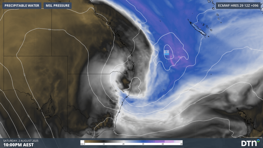
Image: Forecast precipitable water and Mean Sea Level Pressure (MSLP) on Saturday, August 2, 2025 showing a deep feed of tropical moisture wrapping around low pressure into eastern NSW.
Heavy rain over a period of about 36-48 hours between Friday, August 1 and Sunday, August 3, could amount to falls of 100-150mm in some parts, most likely between the Mid North Coast and the South Coast. Localised flooding could disrupt road and rail transport logistics.
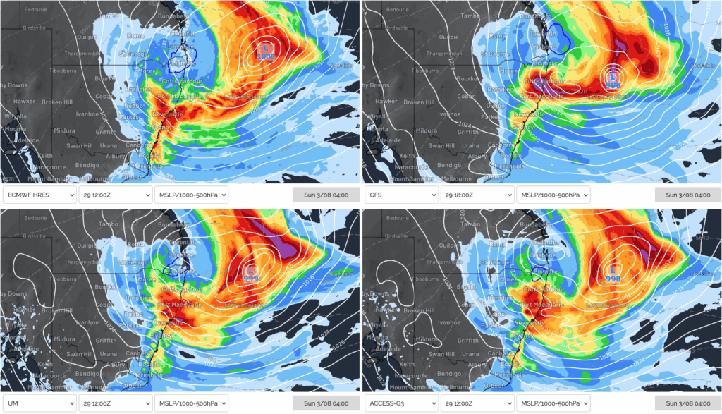
Image: Forecast 24-hour rainfall and MSLP to early on Sunday, August 3, 2025, showing heavy rainfall across parts of NSW’s Mid North Coast, Hunter and Sydney regions from four different weather models.
Powerful easterly swell to lash NSW and southeast Queensland port and maritime operations
Regardless of where the system intensifies, a broad area of easterly gales will set up across the Tasman Sea over the weekend, directed towards the NSW coastline.
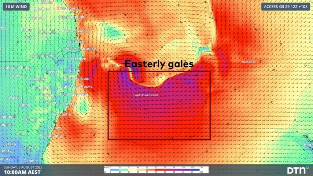
Image: Easterly gales directed towards the NSW coastline on Sunday, August 3, 2025, generating large seas.
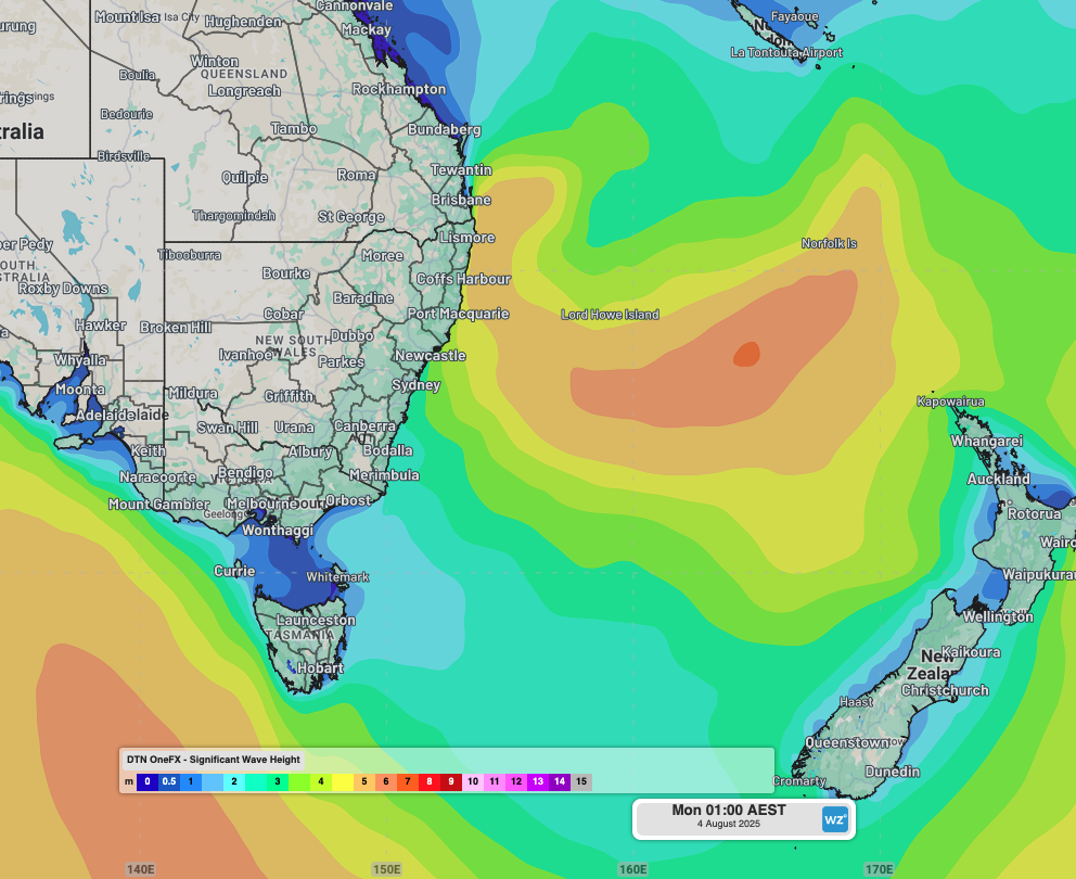
Large seas exceeding 6 metres will be generated by these winds across much of the Tasman Sea. Between late Saturday and Sunday, the swell will muscle into coastal NSW and southeast Queensland with significant wave heights reaching 3-4 metres. Parts of the Mid North Coast and Northern Rivers, most likely between Byron Bay and Seal Rocks, should see the largest waves, with the swell reaching 4.5-5.5 metres late on Sunday and into Monday.
Video: OneFX forecast significant wave heights across the Tasman Sea between Friday, August 1 and Wednesday, August 6, 2025.
Significant wave height is the average of the largest third of the waves recorded over the measuring period – a value used to represent the noticeable ocean conditions for mariners. Maximum wave heights usually double the significant wave height, so parts of NSW’s coastline could see maximum wave heights exceeding 10 metres at times.
The swell direction will start off from the southeast but is then expected to swing to a more direct easterly direction during Sunday and Monday. Easterly swells are especially hazardous as they bypass the headlands that protect beaches, ports and harbours from the more typical south swells. This also enhances coastal erosion across hotspots like Byron Bay’s Main Beach, the Central Coast’s Wamberal Beach, and Sydney’s Collaroy Beach, which are usually protected from south swells.
After the peak in swell height, continued longer period easterly swell energy should persist into mid-next week. Easterly swell with peak wave periods of about 12-13 seconds will have less height but carry lots of energy and continue to batter the NSW coastline.
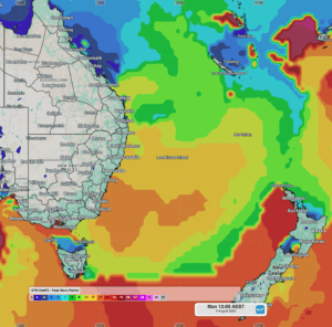
Image: OneFX forecast peak wave periods of 12 to 13 seconds impacting the NSW coastline on Monday, August 4, 2025.
How DTN APAC assists marine, ports and offshore industries
DTN APAC offers a comprehensive suite of services, refined through years of collaboration with the marine, ports and offshore industries, to optimise the safety and efficiency of your operations.
We work with you to understand your intrinsic operational challenges and customise high-precision forecasting, metocean and aviation services to your exact location and operational scope.
When working offshore, our solutions can underpin planning and safe execution for offshore oil and gas enterprises and wind farms. Our data can support your exploration, development, rig moving, shuttle tanker operations, and production and decommissioning phases. Whether your crews are on-site, being transported to shore, or diving to perform maintenance, we deliver tailored weather risk briefings to ensure you choose the optimal time to proceed.
DTN APAC’s trusted nowcasting and forecasting system, OpticastTM, allows you to rapidly respond to changing conditions offshore, en route and in port. We take your port topography and berth orientation into account, ensuring site-specific forecasts. For offshore oil & gas, wind farms, ports and logistics, we have your weather situational awareness covered, no matter where you are. We deliver real-time severe weather and lightning alerts to your team via your integrated dashboard: Portzone, and our Weatherguard app.
DTN APAC’s Total Lightning Network (TLN) ensures you avoid hours of unnecessary downtime by providing the most accurate technology in lightning detection and alerting. Safeguard your teams and assets with lighting and Dangerous Thunderstorm Alerts (DTAs), customised to your existing parameters and delivered in real-time across all devices in your network. You gain full spatial awareness of developing severe weather systems, allowing you to plan ahead and, where needed, execute your shutdown and evacuation procedures.
With extreme conditions slowing production and affecting infrastructure, safety and transport, trust us to deliver Australia’s most precise weather data and tailored insights, giving you decisive confidence when it’s most needed.
Learn more about our large range of industry leading products and services or email us at sales.apac@dtn.com


