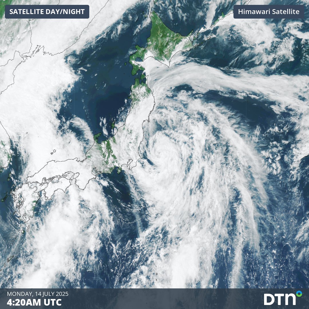
Tropical Storm Nari, the fifth tropical cyclone of the western Pacific typhoon season formed over the weekend, and is tracking close to Tokyo and northern Japan on Monday.
As seen in the satellite imagery below, Nari tracked north rapidly on Monday morning, coming within 250 kilometres of Tokyo around midday.
Video: Satellite imagery of Tropical Storm Nari on Monday morning, July 14, 2025.
Powerful winds reaching 40-45 knots (75-85 km/h) are expected within proximity to the centre of the system, with a broader area of gales extending across the eastern flanks of the low.
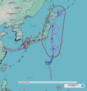
Image: Forecast track of Tropical Storm Nari with areas of gales (above 34 knots) and the forecast position uncertainty as seen on the DTN APAC Stormtracker dashboard.
Coastal parts of the Kantō, Tōhoku and Hokkaidō prefectures can expect gusty winds on Monday and Tuesday as the storm tracks parallel to the coastline. Strong southerly winds may persist into Wednesday as Nari crosses Hokkaidō into the Sea of Okhotsk and over the Kuril Islands.
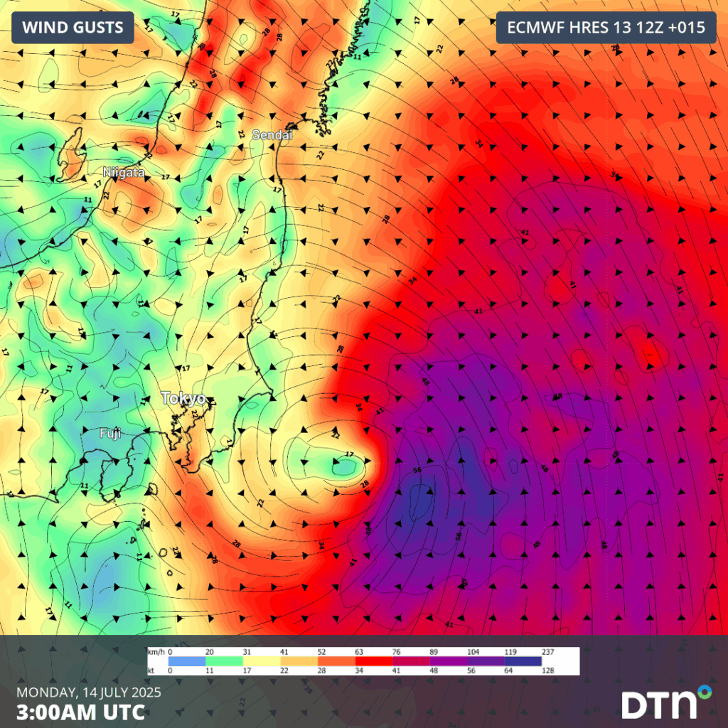
Image: Forecast 10m wind gusts at 12pm JST on Monday, July 14, 2025.
The strong winds around this system will also generate large waves battering into the eastern Honshu and Hokkaidō coastline until Wednesday. The strong winds and large swell are a significant hazard to shipping routes that cross the region, causing costly delays and extra fuel costs of alternative routes.
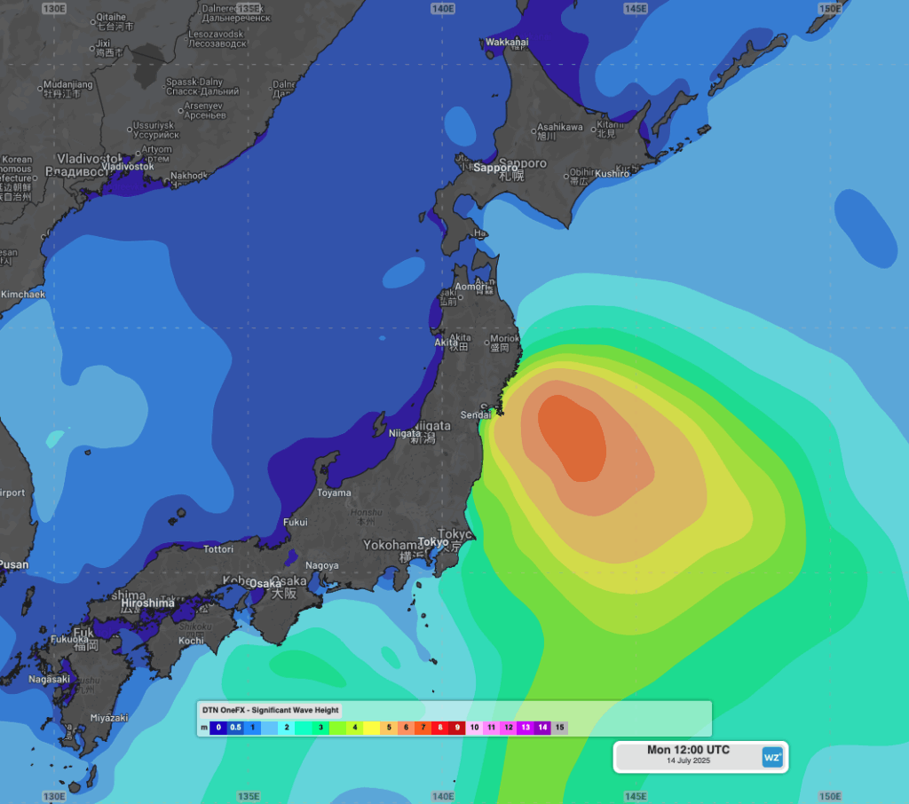
Image: OneFX forecast significant wave heights at 9pm JST on Monday, July 14, 2025.
Some heavy rainfalls are expected on Monday, but a deep stream of moist southerly winds will feed intense and flooding rainfall into Shikoku and southern and central parts of Honshu, including Tokyo, between Tuesday and Thursday. Widespread falls of 150-300mm are expected over these regions.
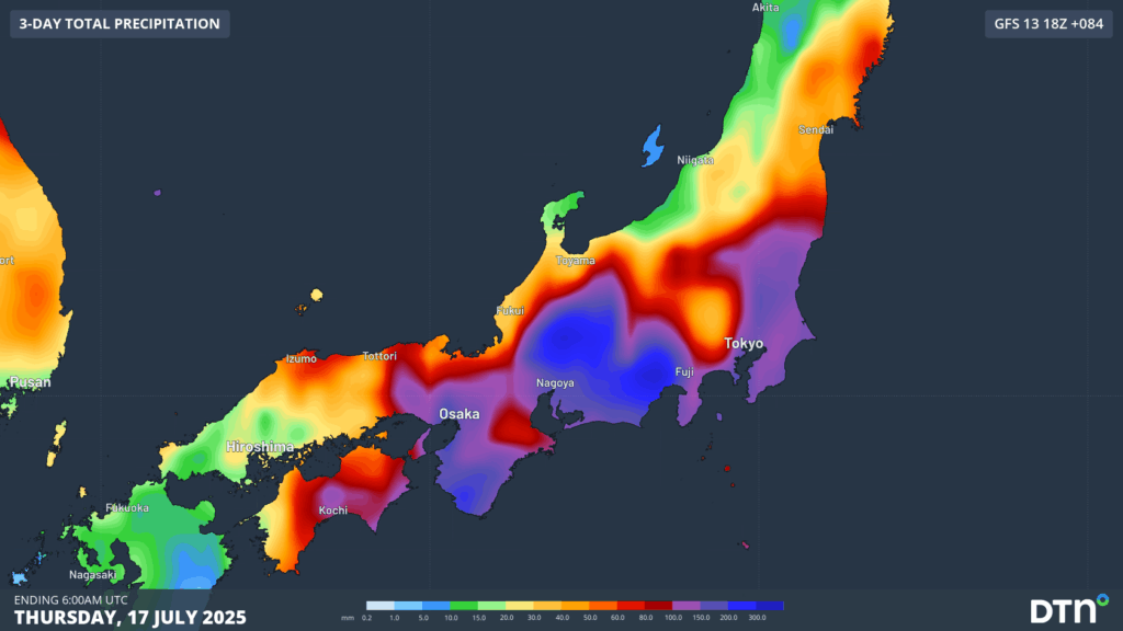
Image: Forecast rainfall to 3pm JST on Thursday, July 17, 2025.
Rainfall will contract west on Thursday, with some heavy falls persisting over Shikoku and Kyushu islands on Friday. Much more stable conditions are expected over the coming weekend as a high pressure ridge strengthens over the Japan region, extending into next week.
Intense bursts of tropical rainfall from atmospheric rivers and typhoons in the region cause huge disruption to transportation, mining and tourism industries, through flooding, landslides and hazardous conditions.
How DTN APAC supports businesses through typhoons
DTN APAC specialises in industry-leading forecast, alerting and threat analysis of tropical cyclones across Australia and Asia, offering you expert, customised solutions when the weather turns wild.
Providing rapid-update forecast information, we alert you to any low-pressure system gaining power within your region and, unlike other providers, can track its development out to 7 days. This gives you the time to prepare and safeguard your staff, sites and assets.
You will have the most precise weather intelligence charting rainfall, wind speeds and potential storm surges to help you make critical decisions quickly. Whether it’s adjusting key work schedules, protecting your staff or securing your site, we have the alerting capability to keep you steps ahead of the storm.
As the climate delivers increasingly severe weather events, their potential to impact your business operations grows.
Whether it’s preparing for the coming season’s tropical storm potential, or rapid-response forecasting with a typhoon approaching, or simply ensuring your operations team is equipped to confidently make decisions ahead of severe weather, our weather Risk Communicators are here for you.
Our weather risk communicators deliver short- to long-term guidance from:
- hourly-event weather monitoring (alerting you of impending destructive winds and heavy rain ahead of a tropical cyclone).
- week to month operational planning based on likely timing of increased monsoonal rain or periods of reduced cyclone activity.
- seasonal long term planning based on climate drivers and the likely trends across the coming months.
We deliver clear and comprehensive weather data, personalised risk assessments and briefings to you and your team, so that your critical decisions can be made with confidence.
We are available 365 days a year, so you always have the timely guidance you require, especially when severe conditions hit.
You have our insights to rely on to see you through complex situations, minimising potential loss of profit and maximising the safety of your staff and assets.
Learn more about our large range of industry leading products and services or email us at sales.apac@dtn.com


