The Indian Southwest Monsoon will reach India in the next two weeks, but a developing El Niño could signal a drier than normal monsoon for Indian businesses and industries.
Southwest monsoon onset over southern India in the next two weeks
The Indian Meteorological Department (IMD) is responsible for tracking the advance and retreat of the monsoon over India. This weekend, the IMD issued the first progression of the northern limits of the southwest monsoon, just reaching the Andaman Sea and Andaman & Nicobar Islands on 16 May 2026, over the southern reaches of the Bay of Bengal. According to the IMD, the monsoon onset is likely to reach Kerala on 26 May 2026 (with a model error of ± 4 days), five days ahead of the normal onset date of June 1st.
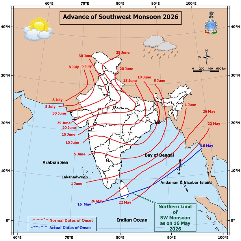
Image: Advance of the 2026 southwest monsoon onset (blue) and the normal dates of onset (red). Source: IMD
To make this early forecast onset date the IMD monitors these key monsoon predictors:
- Minimum temperatures over Northwest India
- Pre-monsoon rainfall peak over South Peninsula
- Cloudiness over the South China Sea and northeast Indian Ocean
- Trade wind strength over the southeast and northeast Indian Ocean
The southwest monsoon is characterised by a surge of westerly winds extending 5-7 kilometres above sea level. These winds are laden with moisture from the Arabian Sea, bringing periods of heavy rainfall and squally conditions across much of southern India.
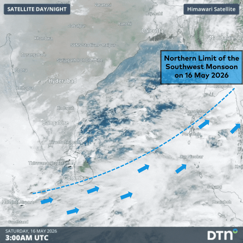
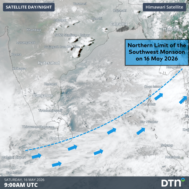
Image: Moisture laden monsoon clouds can be seen on satellite imagery moving from west to east over the southern Bay of Bengal on Saturday, 16 May 2026. Source: DTN
The southwest monsoon usually takes 4-6 weeks to progress into the far north of the country. The Western Ghats, an insurmountable mountain range along the west of India, splits the monsoon into the Arabian Sea and Bay of Bengal branches.
DTN APAC Explainer: The Indian Monsoon
The onset of the monsoon over the Indian sub-continent brings relief from sweltering heatwaves, but the heavy rainfall led to significant disruptions to transport, energy and mining sectors. The monsoon rains are also imperative to India’s agriculture sector, with about three quarters of India’s rainfall occurring during the monsoon season. Nearly half of the Indian population is employed by the agricultural sector, which contributes greatly to the country’s economy.
How climate drivers will impact the 2026 Indian summer monsoon
The IMD predicts below normal (95-90% of the Long Period Average (LPA)) rainfall across India during the 2026 southwest monsoon season.
The dominant factor driving the below average rainfall expected during the coming monsoon season is the predicted strong El Niño developing in the equatorial Pacific Ocean. While occurring in a different oceanic basin, El Niño events shift the Walker Circulation pressure pattern, leading to higher than normal pressure over the eastern Indian Ocean and weaker monsoonal winds. As a result, El Niño events are typically associated with reduced monsoonal rainfall and increased potential for drought, especially over northwestern and southeastern India.
More locally, the Indian Ocean Dipole (IOD) could move towards the positive phase late in the monsoon season. Positive IOD events are characterised by warmer than average waters in the IOD West region (see below), near the Horn of Africa. Warmer waters to the southwest of India increase the moisture content of monsoonal winds and can lead to increased rainfall during the rainy season. If this positive IOD event can become established, it will most likely peak after the end of the southwest Indian monsoon season, which runs till about September, but could contribute to increased monsoonal rainfall late in the season.
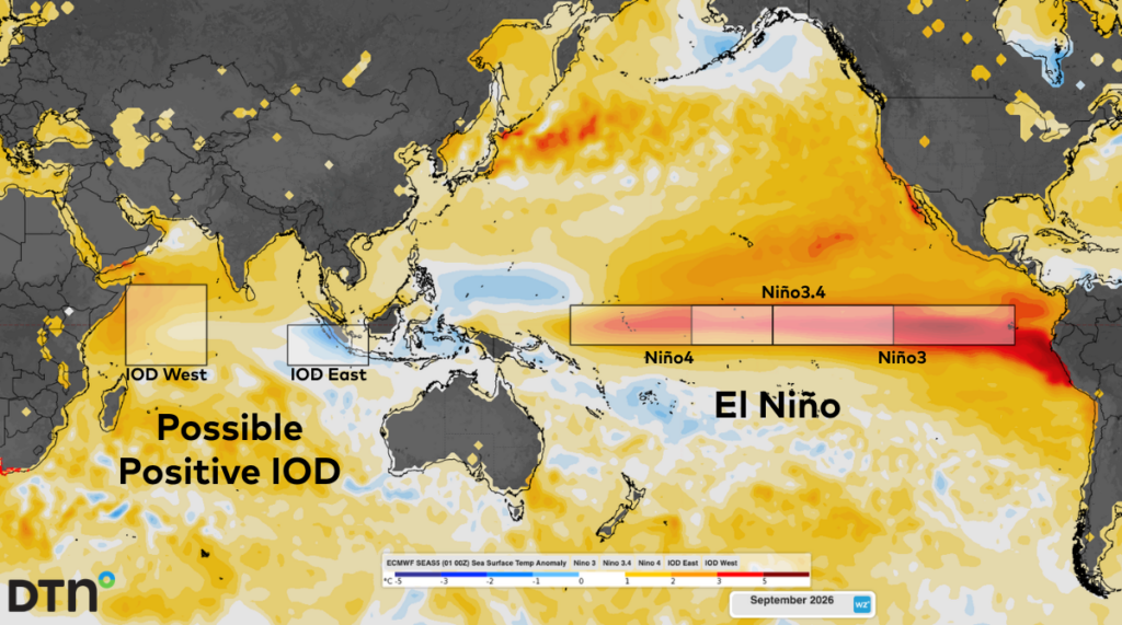
Image: Sea Surface Temperature Anomaly forecasts across the Indian and Pacific oceans during September 2026, showing the strong El Niño and possible positive IOD events. Source: DTN
Another factor that seasonal forecasters need to consider ahead of the monsoon season is the northern hemisphere snow cover, especially around Siberia. The start of 2026 saw slightly below average snow cover extent, which can increase land warming during the springtime (reflecting less solar energy). This allows warm air to rise to the north of India, decreasing the pressure and drawing stronger monsoonal winds early in the season. As a result, an earlier monsoon onset over the sub-continent is possible in the coming weeks.
Under the influence of these climate drivers, along with seasonal computer modelling, the IMD predicts India will experience 92% of the Long Period Average (LPA) monsoon season (June to September) rainfall, with a model error of ±5%. While below average rainfall is forecast across broad parts of the country, parts of northeastern, northwestern and South Peninsular India could see average to above average rainfall, as seen in the seasonal model output below.
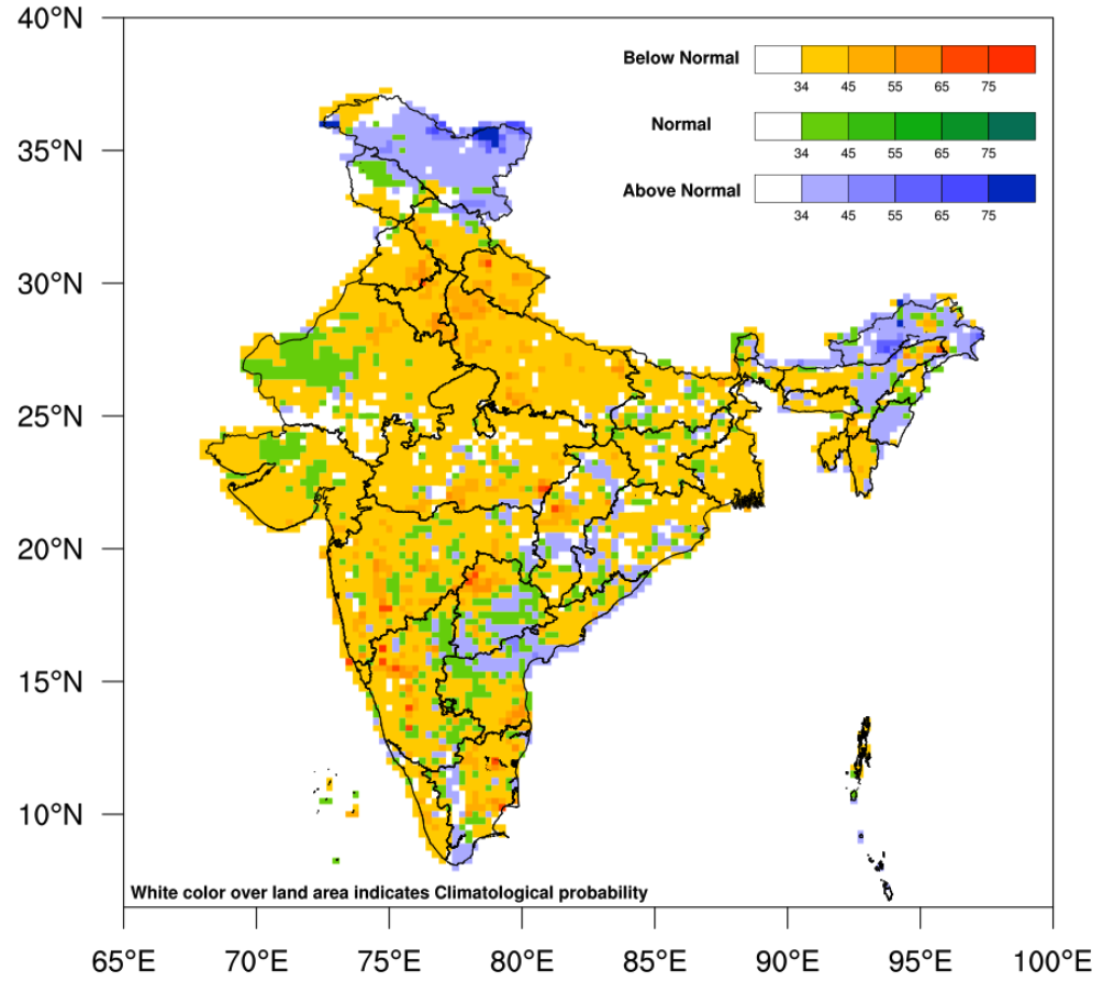
Image: Probability forecast of below normal (yellow to red), normal (green) and above normal (blue) of 2026 southwest monsoon season (June to September) rainfall across India. Source: IMD
The 2025 southwest monsoon season featured heavy rain periods. The cumulative rainfall across the country throughout the season was 937.2mm, 107.9% of the long period average (LPA) of 868.6mm.
DTN APAC’s review of the 2025 southwest monsoon season
Excesses or deficiencies in monsoonal rainfall can lead to floods or droughts, impacting India’s food security, livelihood and overall economy. Replenishments of water resources like rivers, lakes and groundwater vital for irrigation and drinking water supplies also impact hydropower energy generation.
How DTN APAC supports businesses through seasonal changes in tropical cyclones and monsoonal rain activity
DTN APAC specialises in industry-leading forecast, alerting and threat analysis of tropical cyclones across Australia and Asia, offering you expert, customised solutions when the weather turns wild.
Providing rapid-update forecast information, we alert you to any low-pressure system gaining power within your region and, unlike other providers, can track its development out to 7 days. This gives you the time to prepare and safeguard your staff, sites and assets.
You will have the most precise weather intelligence charting rainfall, wind speeds and potential storm surges to help you make critical decisions quickly. Whether it’s adjusting key work schedules, protecting your staff or securing your site, we have the alerting capability to keep you steps ahead of the storm.
As the climate delivers increasingly severe weather events, their potential to impact your business operations grows.
Whether it’s preparing for the coming season’s tropical storm potential, or rapid-response forecasting with a typhoon approaching, or simply ensuring your operations team is equipped to confidently make decisions ahead of severe weather, our weather Risk Communicators are here for you.
Our weather risk communicators deliver short- to long-term guidance from:
- hourly-event weather monitoring (alerting you of impending destructive winds and heavy rain ahead of a tropical cyclone).
- week to month operational planning based on likely timing of increased monsoonal rain or periods of reduced cyclone activity.
- seasonal long term planning based on climate drivers and the likely trends across the coming months.
We deliver clear and comprehensive weather data, personalised risk assessments and briefings to you and your team, so that your critical decisions can be made with confidence.
We are available 365 days a year, so you always have the timely guidance you require, especially when severe conditions hit.
You have our insights to rely on to see you through complex situations, minimising potential loss of profit and maximising the safety of your staff and assets.
Learn more about our large range of industry leading products and services or email us at sales.apac@dtn.com


