
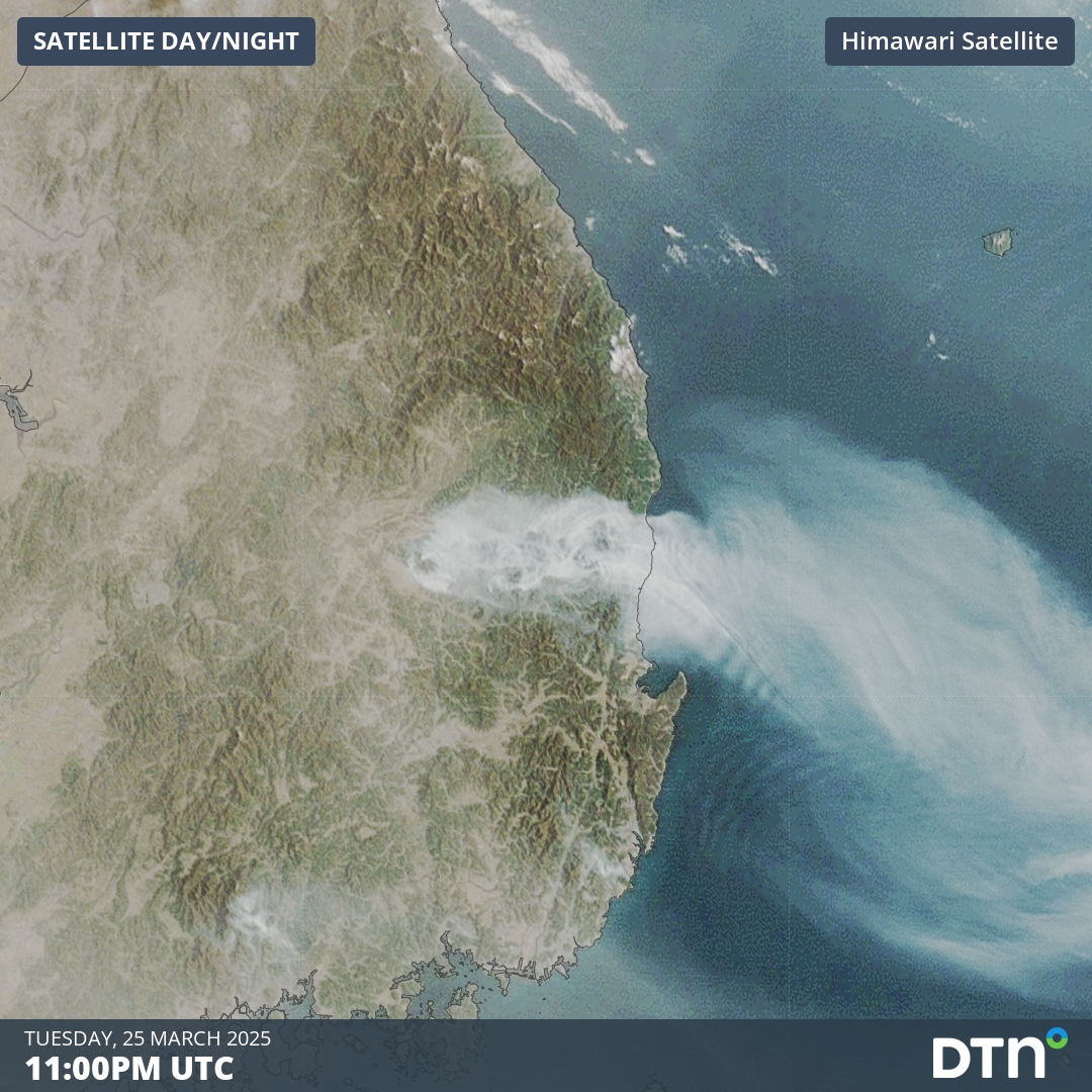
Deadly wildfires have burnt across South Korea’s southeast since last weekend, claiming the lives of at least 28 people and displacing nearly 40,000.
At least 28 people have lost their lives to the fire and more than 35,000 hectares of forest have burnt, displacing nearly 40,000 people from their homes. Officials on the ground are reporting this as the deadliest and largest wildfire since the Korea Forest Service started keeping records in 1987.
The wildfires started last weekend, March 22 and 23, about 150 kilometres southeast of Seoul, in the province of Gyeongsangbuk-do. Hot and very dry westerly winds fanned the blaze to the east between Saturday and Wednesday. As seen in the video below, the smoke plumes from the fire are propagated eastward by the winds.
Video: Satellite imagery between Monday, March 24, and Wednesday, March 26, over South Korea showing the masses of smoke from the wildfires in the southeast of the country.
As seen in the final frames of the video above, the smoke makes a turn to the north on Wednesday as a cooler, more humid southerly wind brings some relief to the firefighting effort. These conditions mostly persisted on Thursday and into Friday with a few scattered showers crossing the region with a cold front.
Much colder conditions are forecast over the weekend, with nights dropping below 0°C, as cold air moves in behind the front. Even with the colder temperatures, winds will be very dry and gusty, descending from the Tibetan Plateau. Dew point temperatures, a representation of the moisture in the air, will drop from the mid-teens on Thursday afternoon, down to around -20°C on Friday afternoon and on Saturday. This very dry air will combine with gusty westerly winds of around 50-60km/h in the afternoons, reaching up to 70km/h on Saturday, as seen in the image below.
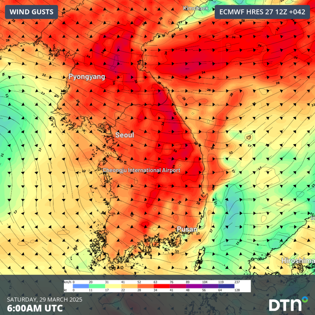
Image: Forecast wind gusts at around 3pm KST on Saturday, March 29.
The very dry and gusty winds will make it difficult to contain ongoing fires, with flames and embers pushing eastward. Firefighters in the region are working hard to contain the fires ahead of this weekend, protecting people, homes, businesses and UNESCO-listed temples in the region.
A high pressure ridge should strengthen over the southern Korea Peninsula from next week, bringing calmer winds and gradually warming temperatures.
How DTN APAC can help
DTN APAC serves the forestry and emergency sectors, delivering trusted weather data and severe weather alerting to maintain safety, protect your assets and underpin your planning.
DTN APAC’s trusted nowcasting and forecasting system, OpticastTM, is independently proven to outperform other industry models, allowing you to respond rapidly to changing conditions. Opticast can ingest data from your on-site weather observation equipment, ensuring your forecast is customised to your local microclimate. From nowcasting and 14-day forecasting to seasonal outlooks, you have powerful, hyper-local weather alerting and intelligence, giving you decisive confidence when it’s most needed.
With lightning a prominent cause of forest fires, DTN APAC’s Total Lightning Network offers real-time detection and unsurpassed accuracy of lightning strikes to <200m. Based on a vast sensor network, both intra-cloud and cloud-to-ground strikes are located, ensuring you are alerted when severe weather is building and threatening your teams, assets and infrastructure. When volatile conditions increase the ferocity of fire it’s imperative you have lead-time to enact safety plans, keeping your people out of harm’s way.
Visualise storm and bushfire activity in real-time, optimising your safety response. Stormtracker is our Global Information System (GIS) tracking tool, providing multiple weather layers and zoom controls, overlaid on a map of your geofenced site locations and infrastructure.
Your DTN APAC dashboard displays your required intelligence, including fire danger forecasts, nowcasting and forecasting, numerical weather prediction, aerological diagrams, flight route cuts and alerting. You gain powerful decision support tools for weather preparedness and response.
Access bushfire and flood risk forecasts and warnings, lightning and severe weather alerting, all in one place. Risk is communicated in real-time in the field via our industry app Weatherguard, or at the desk via your dashboard.
We are there for you when you need us the most – 24/7, 365 days a year.
To find out more about large range of products and services contact us at sales.apac@dtn.com




