A heatwave scorching northern India over at least the next seven days will place a tremendous strain on people and infrastructure.
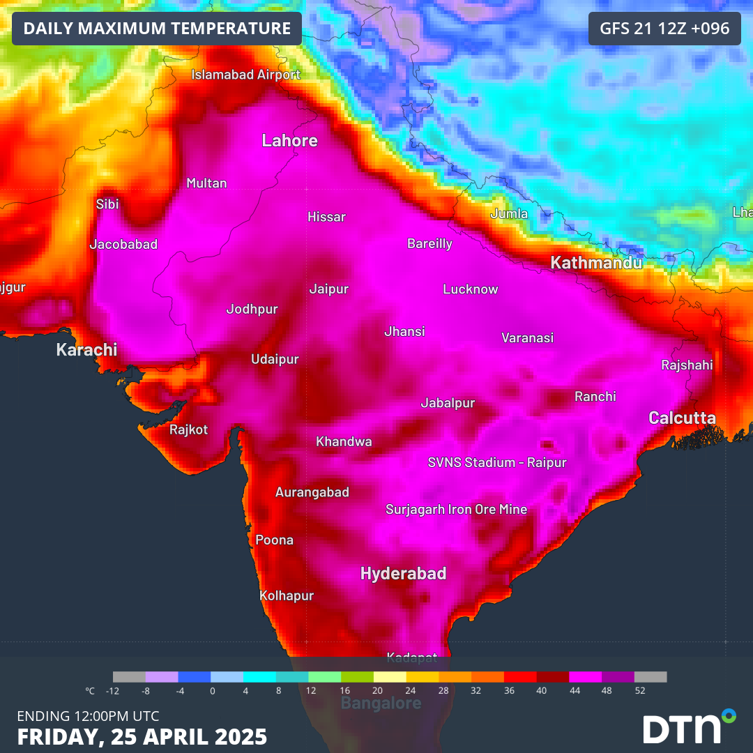
The images below show the concerning heating pattern taking hold of India’s north as the week progresses. Maximum temperatures are shown reaching the low to mid 40s on Wednesday, April 23 (top image), the mid 40s on Friday, April 25 (middle image), and soaring to the high 40s over parts of Pakistan and northeast India on Tuesday, April 29 (bottom image).
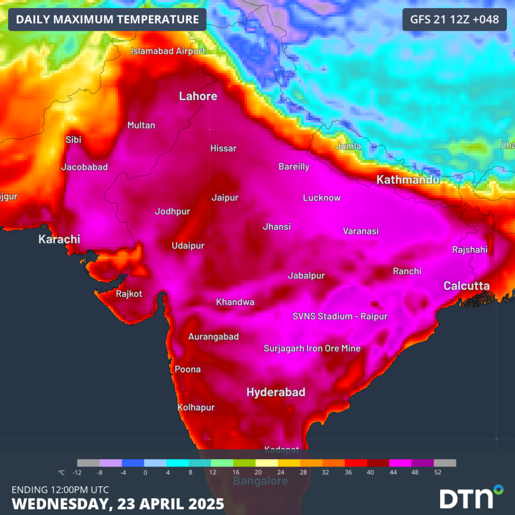

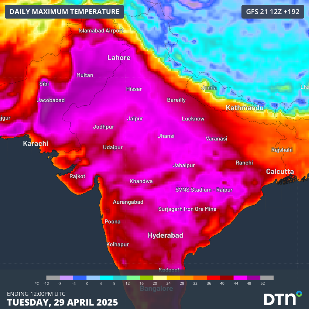
Images: Maximum temperatures on Wednesday, April 23 (top), Friday, April 25 (middle), and Tuesday, April 29 (bottom).
This persistent and oppressive bout of heat will be accentuated by overnight temperatures struggling to drop below the mid 20s throughout the coming week. Delhi is forecast to reach maximum temperatures of either 40 or 41°C, with nights only dropping to 25 or 26°C, until at least Sunday, April 27, about 3-4°C warmer than normal.
Where is this heat coming from?
Looking at the image below, much of the Indian subcontinent is expected to be mostly void of any rainfall until the end of this week. This is due to a high pressure ridge extending from the Arabian Sea, drawing hot and dry west to northwest winds from deserts to the northwest.
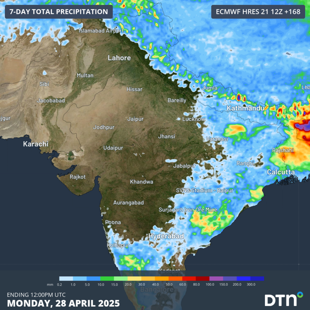
Image: Rainfall accumulations across India until Monday, April 28.
With little or no rainfall expected in the coming week, the hot and dry winds will maintain these intense heatwave conditions well into next week.
Is relief on the way?
Some thunderstorm activity and cooler temperatures are expected over Bangladesh and northeast India from this coming weekend and early next week. However, central and northern parts of the country may need to wait till later next week and possibly till the start of May before minor relief comes.
Early outlook for the Southwest Monsoon season rainfall
In mid April, the Indian Ministry of Earth Sciences put out a press release on the early outlook long range forecasts for the Southwest Monsoon seasonal rainfall. Some of the key takeaways from this early outlook included:
- An above average rainfall Southwest Monsoon season (105% of the long period average) for India as a whole.
- Normal Monsoon influences from Neutral conditions in both the El Niño Southern Oscillation and the Indian Ocean Dipole.
- Possible increase in Indian monsoon rainfall with below average snow cover over Eurasia.
Unfortunately, this above average rainfall outlook doesn’t extend across the whole country. Parts of northwest and northeast India currently experiencing the searing heatwave are forecast to receive below average monsoon rainfall.
DTN APAC Explainer: The Indian Monsoon
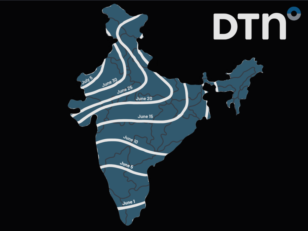
Image: The typical monsoon arrival date for Indian regions. Data: Indian Meteorological Department
The Southwest Indian monsoon typically sweeps over the Indian continent between late May and June, with rain lasting till about September. This brings about 80% of India’s annual rainfall, however rainfall distributions across the country are immense.
Particularly across northern and central India, where the monsoon only arrives from about mid June onwards, the increasingly hot temperatures in May and June put tremendous stress on the people, agriculture and energy infrastructure. The arrival of the monsoonal winds bring much needed relief to most of the continent. However, there have been years where the needed rainfall has not progressed into the Delhi region and northwest India, which are referred to as monsoon failures. This brings tremendous stresses to people and industry depending on the needed relief.
How DTN APAC services the energy sector
When your energy operations are affected by weather extremes, we offer solutions to keep your productivity and profits high.
DTN APAC, supplies precise weather intelligence and analytics to support all aspects of your business, with a wide range of specialised services covering energy generation and weather forecasting, to site-specific severe weather alerting and historical reporting.
OpticastTM
DTN APAC operates Opticast, an ultra-local forecasting system. Providing an unprecedented level of accuracy and precision, Opticast rapidly updates every 10 minutes, intelligently adapting to local observations, and corrects forecasts based on historical evidence. Wherever you are based, we can provide you with the most accurate nowcasting and forecasting data out to 14 days so that you can mitigate operational and safety risks, and plan to make the most of severe weather windows.
Solar Forecasting and Generation
DTN APAC partners with Solcast, a DNV company – the world leader in real-time actuals and rapid-update solar forecasts.
Utilising Solcast’s satellite fleet, sky-imagers and the SCADA data collected from your solar farm, you will acquire not only forecasting capability, but a precise picture of your actual yield and PR. Specifically built to ensure you meet the requirements and reduce your exposure to costly penalties.
Wind
Utilising Opticast’s data, we provide wind power generation, operational and severe weather forecasting to improve your planning and protect your valuable staff and assets. Utilise generation forecasts for individual wind farms and state level at daily and hourly resolution.
DTN APAC’s Total Lightning Network ensures your wind farm is protected from severe storms by an alerting system that can be configured to your exact requirements, aligning with local site needs, procedures and legislation.
Hydropower
Using Opticast’s nowcasting and forecasting capabilities, you will have long-term outlook covering rainfall and extreme heat events out to 12 months. This can significantly improve your planning as you integrate the data with site-specific hydrological parameters.
DTN APAC’s Risk Communicators
Our Risk Communicators work closely with you to analyse how weather impacts your operations and communicate potential risks. We can then support your risk management planning, and provide situational awareness and post-event reporting when extreme weather events hit hard.
DTN APAC, is a diverse team, with global forecasting, product development and analytics expertise. Couple this with extensive industry experience spanning Aviation to Energy, and we are primed to assist you in strengthening your operational strategies when responding to weather disruption.
We consult with you to understand the nuances of your operations and your existing procedures and policies. We can then assist in creating communication structures, safety strategies and procedures to mitigate the risks that may impact your workforce, assets and uptime.
Rely on our insights to see you through complex situations, maximizing the safety of your staff and assets, and your uptime where possible.
To find out more about large range of products and services contact us at sales.apac@dtn.com


