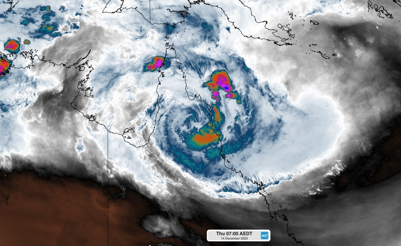
Major flooding is occurring along Queensland’s North Tropical Coast and Tablelands this morning after Tropical Cyclone Jasper dropped more than half a metre of rain in the last 24 hours.
Jasper made landfall as a category two tropical cyclone late on Wednesday, crossing the coast between Port Douglas and Cooktown in the vicinity of Wajul Wajul.
As Jasper approached and crossed the coast, bands of heavy rain and thunderstorms were driven over Qld’s North Tropical Coast and Tablelands in a persistent stream of moisture-laden winds to the south of the cyclone’s core.
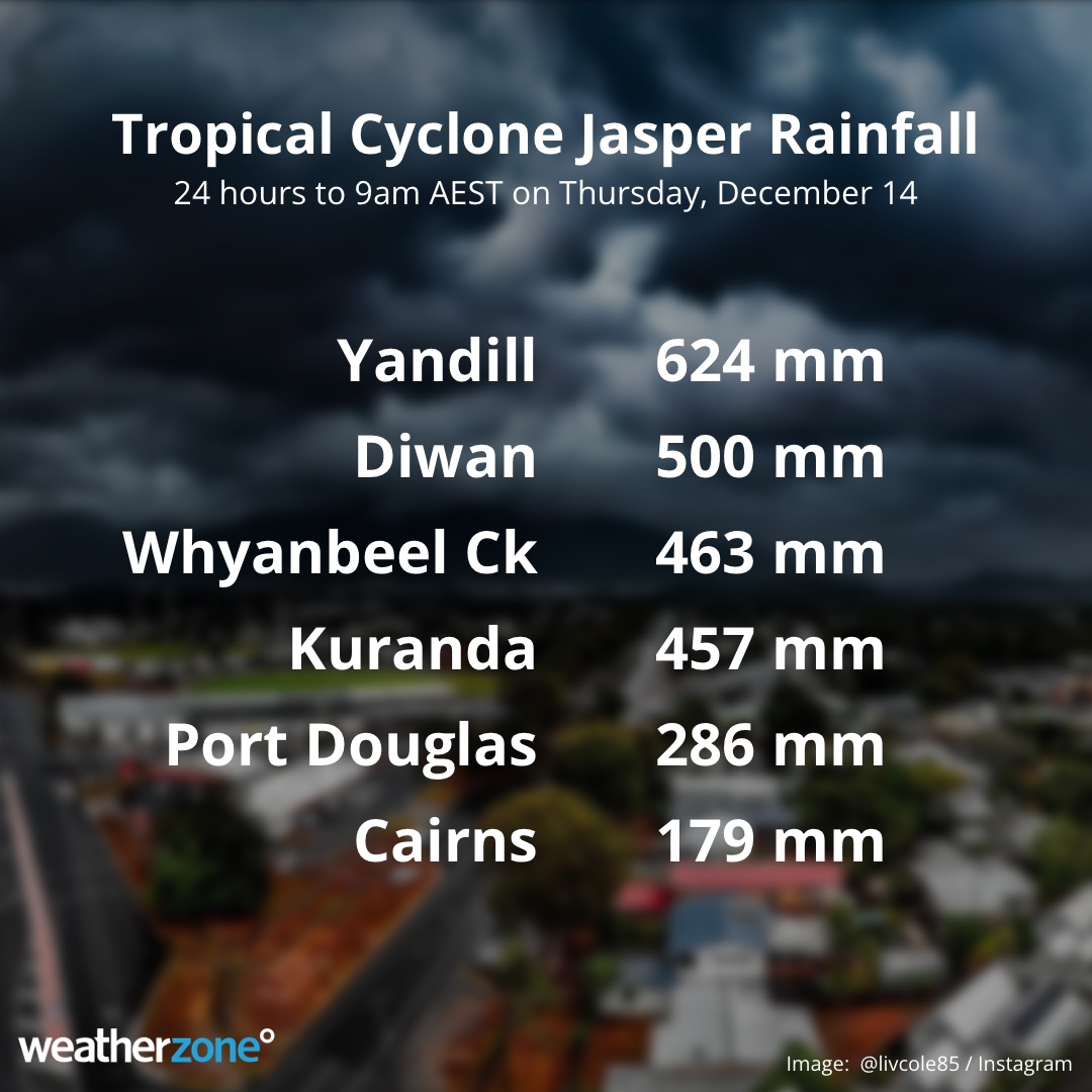
A rain gauge at Yandill in the Daintree region picked up 624 mm of rain during the 24 hours to 9am on Thursday. This included two separate periods of very intense rain, with 3-hour rain rates reaching 148 mm between midnight and 3am, and 130 mm between 6 and 9am.
Another nearby gauge at Whyanbeel Creek saw 160 mm in the three hours ending at midnight on Wednesday night.
This intense overnight rainfall has inundated rivers and creeks along the North Tropical Coast and Tablelands, particularly around the Daintree and Cairns regions.
A major flood warning has been issued for the Daintree River, which exceeded the moderate flood level of 6 metres at Daintree Village shortly before midnight and is expected to rise above the major flood level of 9 metres on Thursday morning. The Daintree River at Daintree Village went from 2.1 metres at 6pm AEST on Wednesday to 8.05 metres at 9am on Thursday, rising 6 metres in 16 hours.
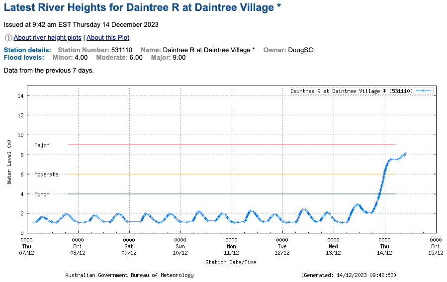
Image: River height observations for the Daintree River at Daintree Village. Source: Bureau of Meteorology
Moderate to major flooding was also occurring to the west of Cairns on Thursday morning, with the Clohesy River at Bolton Road reaching the major flood level of 8 metres at 9:30am AEST and rising.
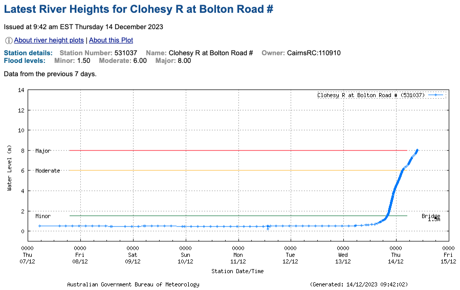
Image: River height observations for the Clohesy River at Bolton Road. Source: Bureau of Meteorology
According to the Douglas Shire Council’s website, numerous roads have been closed in and around Port Douglas due to flooding and thousands of people are being affected by power outages. The council’s webcams also show extensive flooding in the region late on Thursday morning.
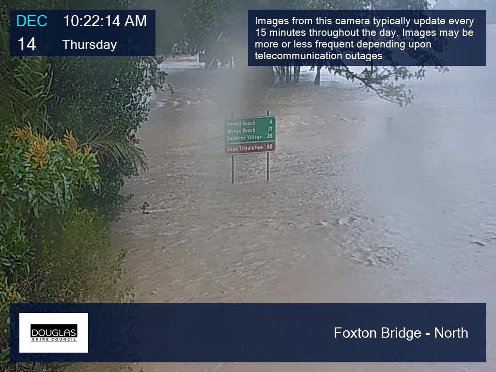
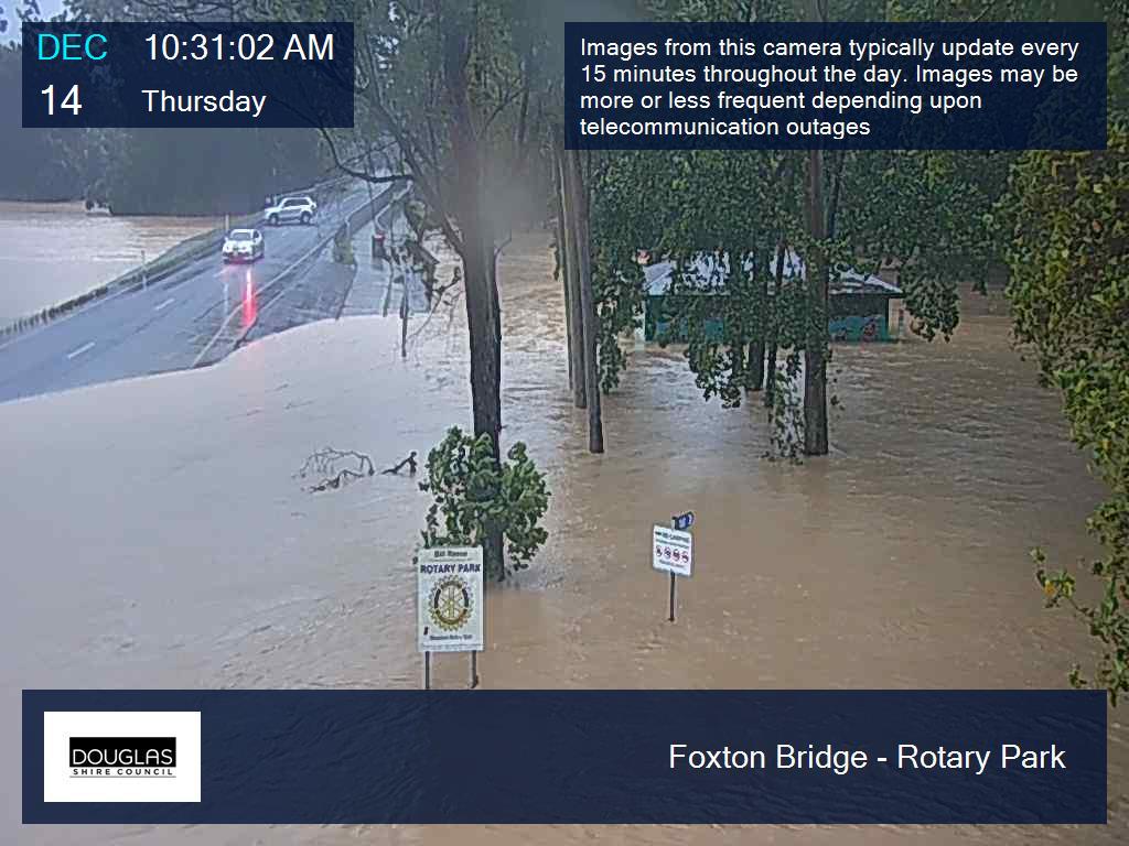
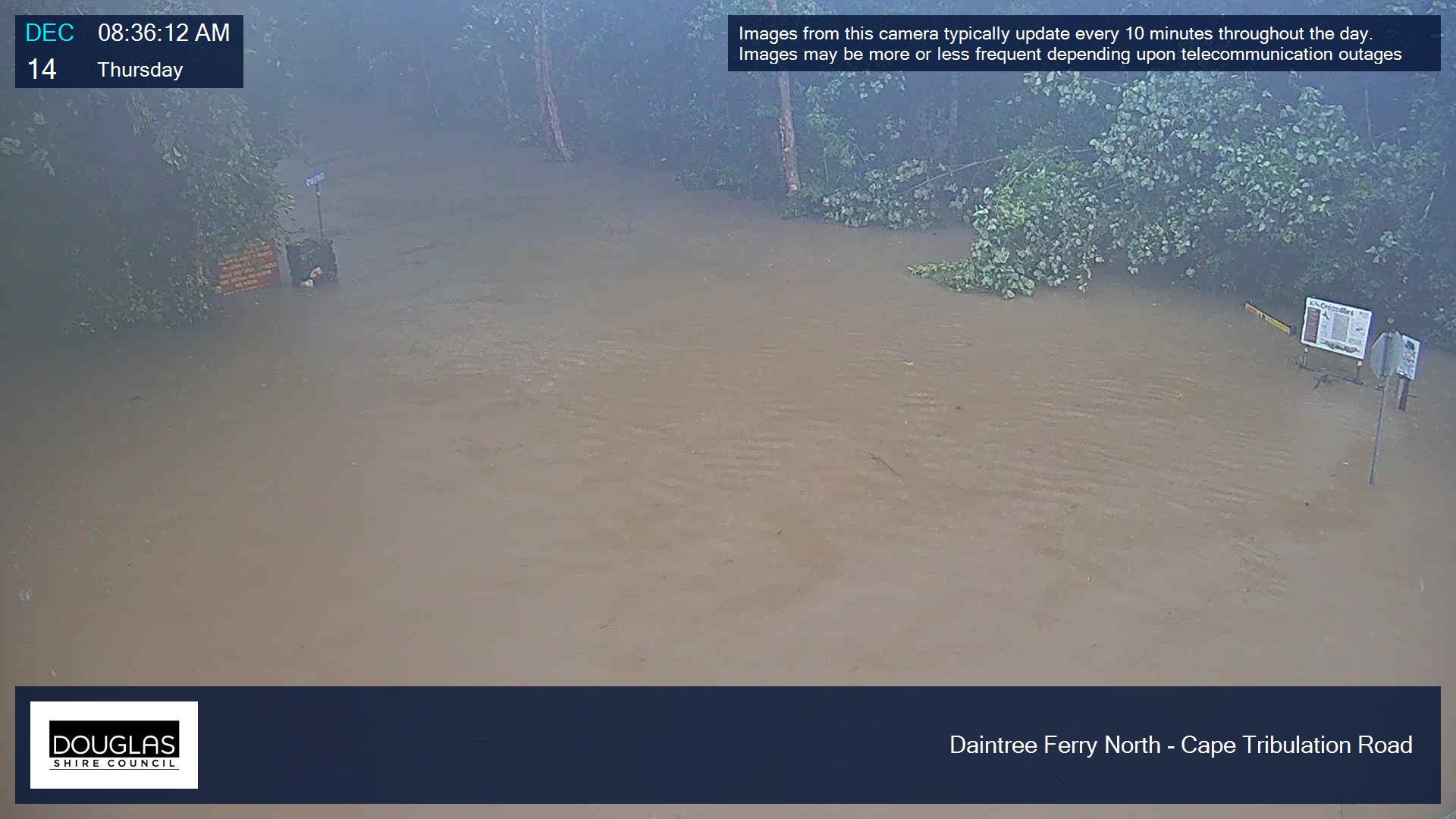
Images: Flood camera images captured by the Douglas Shire Council.
While rain was the most notable feature of Jasper’s landfall, powerful winds were also observed in the rain and storm bands surrounding its core as it approached and crossed the coast.
Low Isles Lighthouse registered wind gusts of up to 115 km/h on Wednesday afternoon, which is the equal strongest December gust on record for the lighthouse, with data available back to 1978.
Tropical Cyclone Jasper weakened below cyclone strength on Wednesday night after crossing the coast. Its remnant low pressure system will now carry heavy rain across Cape York Peninsula before moving out over the Gulf of Carpentaria on the weekend.
At this stage, Jasper’s remnant low pressure system is not expected to intensify into a tropical cyclone while over the Gulf on the weekend and early next week. However, forecasters will be keeping a close eye on the position and strength of system next week, as it has the potential to linger in the Australian region in the lead-up to Christmas.


