Another dangerous thunderstorm outbreak is on the cards for eastern and southeastern Australia from this weekend into next week, with parts of NSW and Vic also forecast to see large daily rainfall totals.
It has been a stormy week for eastern Australia with areas of northeast NSW and southeast Qld accumulating more than 200mm of rain, with more storms expected on Friday.
The next round of thunderstorms will impact parts of Vic and NSW on Sunday and Monday as a cold front moves over the country’s southeastern states.
The atmosphere will be very unstable in southeastern and eastern Australia from this weekend, with warm and humid air to be lifted by the cold front and trough above the surface helping to create large thunderstorms.
The image below shows the forecast lifted Index (a measure of atmospheric instability) for Sunday afternoon, with the blue shades showing an unstable atmosphere across parts of NSW, Qld and Vic.

Image: Lifted Index values at 2pm on Sunday, November 17 afternoon. Areas with lower values (the white and blue shading) show where the atmosphere is potentially unstable, greatly increasing the risk of thunderstorms developing.
This unstable atmosphere is likely to generate some severe thunderstorms, with heavy rainfall and damaging winds the main risks on Sunday and Monday.
The cold front and associated thunderstorm activity is also expected to bring significant rainfall to the northern ranges in Vic and southeastern NSW.
The image below shows that more than 100mm of rain could fall in these areas over the coming days.
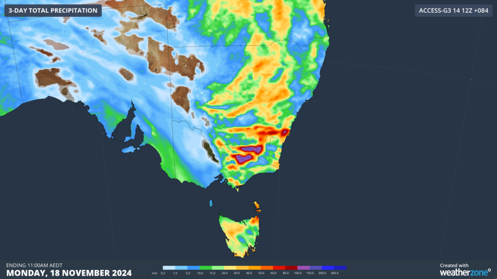
Image: Accumulated precipitation for the 3 days leading up to Monday, November 18, according to access-G
On Sunday, daily totals could reach 60 to 80mm in thunderstorm activity, with a risk of flash flooding.
While rain will ease on Monday, thunderstorm activity will continue across parts of NSW and Qld early next week.
Stormtracker is a severe weather solution that can assist you in observing, in real-time, any storm or event that has the potential to impact your business.
Embedded in DTN’s industry interfaces, the system gives you a time advantage when monitoring conditions developing over your infrastructure and location.
Stormtracker is our Global Information System (GIS) tracking tool, providing multiple weather layers and zoom controls overlaid on a map of your location and infrastructure. You can choose a snapshot or full screen view, depending on your requirements. The maps allow you to monitor all weather, and specifically any systems likely to cause risk for your business. You also have the capacity to observe:
- real time lightning and thunderstorm alerts
- localised lightning strike frequency
- official warnings for storm, cyclone, wind, flood and fire
- sentinel hotspot fires and fire agency current incidents
Stormtracker’s radar imagery updates every 10 minutes, so you are always able to respond rapidly to changing conditions. You can customise alerting to notify you when your staff or infrastructure are under threat. With increased situational awareness, your ability to make informed decisions quickly is optimised.
DTN’s experience and intelligence gives you a clear path through complex situations. Let us assist you, offering actionable insight when extreme weather poses risk to your business. For more information please visit our website or email us at sales.apac@dtn.com.