Severe thunderstorms brought large hail and heavy rain to southeast Queensland’s Wide Bay and Burnett on Thursday, October 2, 2025 – impacting businesses and insurance claims.
Clear skies at midday
It’s 12pm on an early October Thursday and it’s warm and sunny with barely a cloud in the sky and a light seabreeze coming from the sea. You might be a plant operator managing outdoor workers, out in a field or forest overseeing agricultural or forestry operations, or just driving home for lunch with the windows down.
Conditions are pleasant and not too dissimilar to past days – but up in the atmosphere, conditions are shaping up for an explosive afternoon as an upper trough moves into southern Queensland. Warm and humid conditions at the surface, with colder temperatures aloft, have primed the region for a busy thunderstorm day.
Explosive convection near Childers
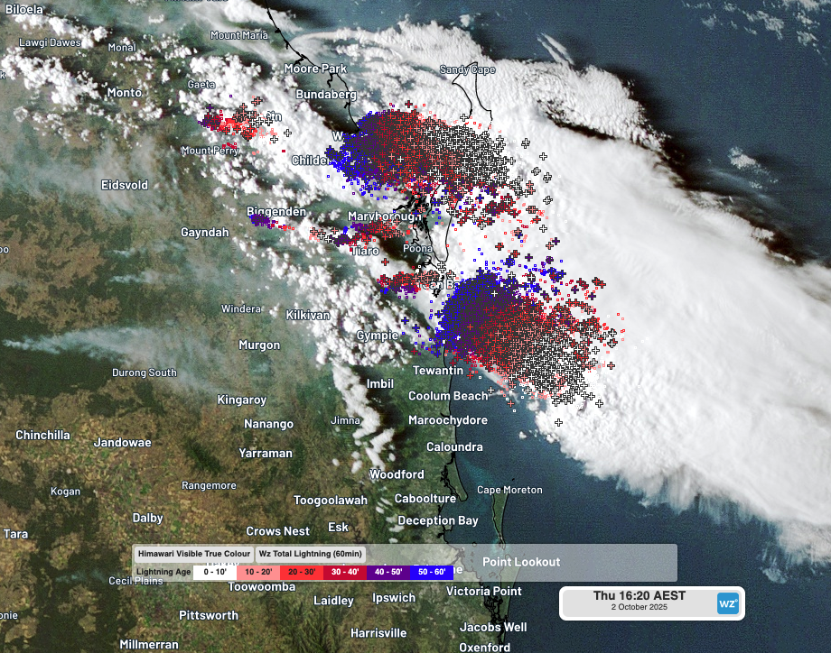
Satellite imagery shows late morning cumulus cloud with cloud top heights of just over 1,500m rapidly exploding upwards to nearly 10,000m in approximately half an hour.
Video: Three-hour satellite loop around the Wide Bay and Burnett region showing explosive thunderstorm development with lightning (purple) on Thursday, October 2, 2025.
26 seconds after 12:34pm, two cloud-to-cloud lightning strikes were recorded about 22 kilometres west-northwest of Childers, and about a minute later the first cloud-to-ground strikes was recorded. In less than 5 minutes, lighting could be detected within 15 kilometres of Childers and less than 10 minutes later lightning and rainfall was over the town.
At this distance, thunder can only faintly be heard – not the ideal scenario if you’re operating heavy machinery. With DTN APAC’s Onguard solution, you’re alerted instantly of lightning detected by our Total Lightning Network (TLN) within proximity of your operations. Onguard can be customised to your Trigger Action Response Plans (TARPs) and other considerations, ensuring you are securing the safety of your sites based on your existing, functional parameters.
At around 1:15pm, 2cm hail was observed at Childers, and a few minutes later, the first Bureau of Meteorology warning for Severe Thunderstorm Warning (Large Hailstones And Damaging Winds) for parts of Wide Bay and Burnett was issued, around 40 minutes after the first lightning strike alert by Onguard. Luckily, you mobilised your team back to the utes and are safe and dry as the rain and hail pelts the top of the truck.
Thunderstorm splits into dangerous right-moving supercell
After crossing Childers, radar imagery shows the thunderstorm splitting into two supercells. While one cell continued on the previous thunderstorm path towards the east, the more southern cell tracked much more south as a dangerous right-moving supercell (a rotating thunderstorm which moves to the right of the main atmospheric wind flow).
Video: Gympie radar imagery on the afternoon of Thursday, October 2, 2025 showing the normal storm motion to the east, with the right-moving supercell splitting off to the southeast towards Maryborough.
This cell moving to the right of the normal storm motion intensified strongly as it moved away from it’s left-moving counterpart, maximising the warm and moist environment all to itself. Intense radar reflectivity can be seen moving over the Maryborough area, where 8cm and 5cm hail was reported at Tinana and Oakhurst, respectively, and southeast into the Tin Can Bay area.
Giant hailstones, as reported near Maryborough, pose an immense risk to outdoor workers needing to find safe cover quickly. Using DTN APAC’s early warning systems you can maximise your lead-time ahead of impending severe weather, and know as soon as possible when it’s safe to return into the field.
DTN APAC’s Total Lightning Network in action
As mentioned above, DTN’s TLN was reporting individual lightning strikes timing down to milliseconds, with accuracy pin-pointing the strike location to less than 200m. Across a period of 9 hours from the first strike west of Childers at 12:34:36.714pm a total of 204,734 lightning strikes were recorded within 200 kilometres of Hervey Bay, with 25,050 of these strikes being ground strikes.
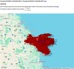
Image: DTN APAC’s TLN detected over 200,000 lightning strikes within 200 kilometres of Hervey Bay between 12:30pm and 9:30pm AEST on Thursday, October 2, 2025.
Take the guesswork out of severe thunderstorms with DTN APAC
In the days leading up to this thunderstorm, forecasts included an elevated risk of severe thunderstorms across the region. Operators aware of this risk can be at the ready with their action plan the moment conditions deteriorate – rather than being left out in the dark, wet and wind.
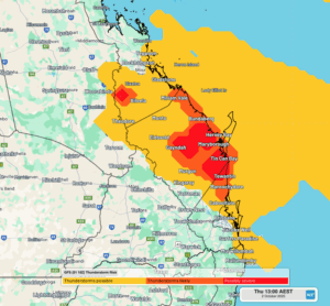
Image: GFS Thunderstorm Risk forecast for the afternoon of Thursday, October 2, 2025.
Once thunderstorms do develop, DTN APAC’s range of severe weather monitoring and alerting solutions, such as Total Lightning Network (TLN), Onguard, Stormtracker and the Weatherguard App keep your staff out in the field, on-site or nationwide, safe with access to real-time alerting and local weather data to support their efficiency and safety.
Video: Satellite, radar and TLN overlaid on the Stormtracker dashboard showing the thunderstorm activity across the afternoon of Thursday, October 2, 2025.
How DTN APAC is helping insurance companies with severe thunderstorm alerts
Given weather affects your business at all levels of operation, from risk assessment to sales and claim management, it’s worth gaining the foresight of our industry-leading, comprehensive weather services.
DTN APAC, offers you trusted weather intelligence, alerting and analytics to support your business, bringing ease to your risk and claims management.
Severe weather and conditions alerting
DTN APAC’s alerting allows your organisation to mitigate severe weather insurance claims and protect policy holders from lightning, hail, bushfires and other natural disasters. Address specific SMS alerts are sent up to 30 minutes prior to a severe storm’s impact, giving your customers time to prepare themselves, protecting both assets and life. Our alerting system combines the proven technology of TITAN Tracks, with our own Dangerous Thunderstorm Alerts (DTAs) and Total Lightning Network, so you are protected by the most precise service available.
Historical severe weather reporting
StormQuery creates storm reports based on historical data from the Bureau of Meteorology and lightning strike information from our own Total Lightning Network. You can draw historical lightning and severe weather reports – geo-tagged to any address and postcode – to quickly and accurately verify severe weather insurance claims. StormQuery is seamlessly embedded within the DTN APAC interface and is easy to visualise and utilise.
Long-range forecasts
Long-range forecasts enable you to prepare for the seasons ahead – whether it’s tropical cyclone risk, La Niña’s above average rainfall or the bushfire seasons of El Niño. With that foresight, you can equip your customers with the strategies they need to mitigate loss due to fire, flood and severe weather. Nurture your relationship with your customers by providing them with the tools to protect themselves and their assets from increasingly volatile conditions. Data from the forecast reports can also be incorporated into your reinsurance negotiations.
Rain, hail or shine: we are there for you, and your customers.
Learn more about our large range of industry leading products and services or email us at sales.apac@dtn.com


