Heavy and persistent rainfall is set to impact parts of eastern Qld and northeast NSW from early to mid-next week, as moisture laden easterly winds stream onto the coast.
The moist easterly winds will extend up to around 2.5km above the surface, transporting a deep layer of moisture into NSW and Qld. Within this deep easterly flow, a low pressure trough has already in the Coral Sea and will move closer to the southeast Qld coast early next week, triggering heavy rainfall in the region.
The satellite image below shows cloud and showers moving onshore the Qld and northeast NSW coastline on Friday morning.
Image: Himawari-9 satellite image at 7am AEST on Friday, August 9.
While showers are expected in the coming days, the heaviest rain is expected between Sunday, August 11 and Thursday August 15.
Widespread falls of 60 to 80mm are forecast on and east of the Great Divide between Cairns and Port Macquarie, with the potential for 100 to 250 mm of rain to fall in this four-day period.
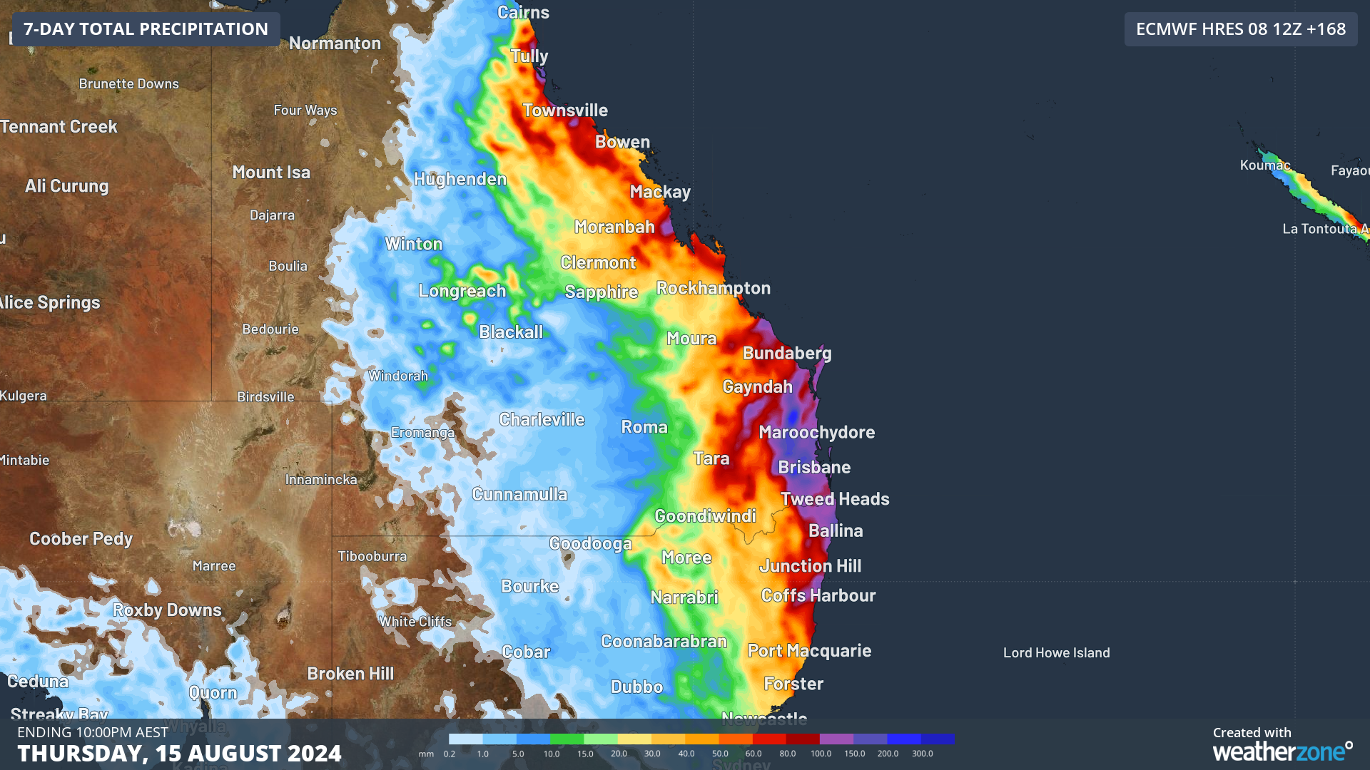
The map below shows that there is still considerable uncertainty about where and when the heaviest rain will fall along this broad area next week. Some computer models suggest parts of southeast Qld, including Brisbane and northeast NSW will be the hardest hit, while another suggests the heaviest falls will remain offshore.

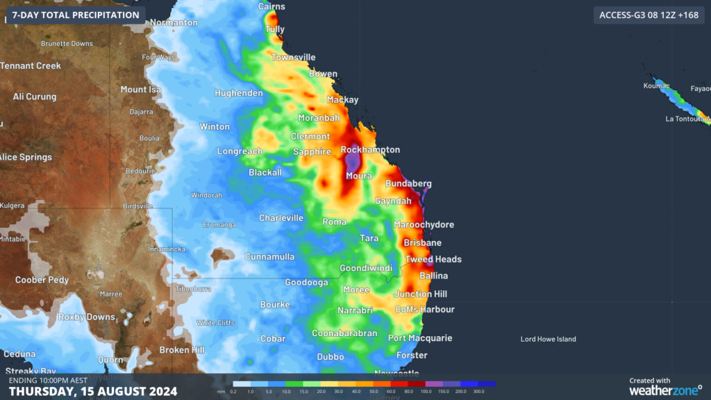
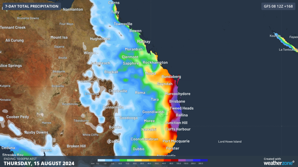
Image: Accumulated rain forecast for the 7-days leading up to 10pm Thursday, August 15, According to (top to bottom) ECMWF, Access and GFS.
Daily rainfall totals could reach 80 to 100 mm early next week, bringing the potential for flooding in parts of Qld and northeast NSW.
We will be watching this system closely as it unfolds, please keep an eye out for the latest warnings.
Are increasingly volatile weather events affecting your insurance company’s bottom line?
Given weather affects your business at all levels of operation, from risk assessment to sales and claim management, it’s worth gaining the foresight of our industry-leading, comprehensive weather services.
DTN APAC, a DTN company, offers you trusted weather intelligence, alerting and analytics to support your business, bringing ease to your risk and claims management.
Severe weather and conditions alerting
Weatherzone’s alerting allows your organisation to mitigate severe weather insurance claims and protect policy holders from lightning, hail, bushfires and other natural disasters. Address specific SMS alerts are sent up to 30 minutes prior to a severe storm’s impact, giving your customers time to prepare themselves, protecting both assets and life. Our alerting system combines the proven technology of TITAN Tracks, with our own Dangerous Thunderstorm Alerts (DTAs) and Total Lightning Network, so you are protected by the most precise service available.
Historical severe weather reporting
StormQuery creates storm reports based on historical data from the Bureau of Meteorology and lightning strike information from our own Total Lightning Network. You can draw historical lightning and severe weather reports – geo-tagged to any address and postcode – to quickly and accurately verify severe weather insurance claims. StormQuery is seamlessly embedded within the Weatherzone interface and is easy to visualise and utilise.
Long-range forecasts
Long-range forecasts enable you to prepare for the seasons ahead – whether it’s tropical cyclone risk, La Niña’s above average rainfall or the bushfire seasons of El Niño. With that foresight, you can equip your customers with the strategies they need to mitigate loss due to fire, flood and severe weather. Nurture your relationship with your customers by providing them with the tools to protect themselves and their assets from increasingly volatile conditions. Data from the forecast reports can also be incorporated into your reinsurance negotiations.
Rain, hail or shine: we are there for you, and your customers. to find out more visit our contact page or email us at apac.sales@dtn.com.


