Globally, ocean temperatures are at record levels for the second consecutive year, and this has played a part in creating one of the costliest hurricane seasons on record in the North Atlantic. Forecasts are suggesting a similar impact of the hot oceans here in Australia for the coming tropical cyclone season.
Link between hot oceans and tropical cyclones
Tropical cyclones (equivalent to a tropical storm) use warm waters as their primary fuel source. Specifically, waters need to be 26.5°C or higher, down to a depth of at least 50m to support a tropical cyclone. With each degree of warmer water above this threshold, a tropical cyclone has more thermal energy it can convert into its powerful winds and structure, increasing the chance a system reaches a higher category.
2024 Atlantic Hurricane Season
The 2024 Atlantic Hurricane Season is still ongoing, running from June to November inclusive, but is already one of the costliest in US history, responsible for over $79 billion in damages and claiming the lives of 341 people. While this season has seen an average number of tropical storms develop so far, it has seen four systems; Beryl, Helene, Kirk and Milton, all of which have reached category 5 strength on the Australian scale.
The primary reason for such a high number of these powerful systems has been attributed to the very warm ocean temperatures in the Gulf of Mexico, and more broadly in the North Atlantic Ocean. Ocean temperatures up to 31.5°C were responsible for Hurricane Milton’s record intensification.
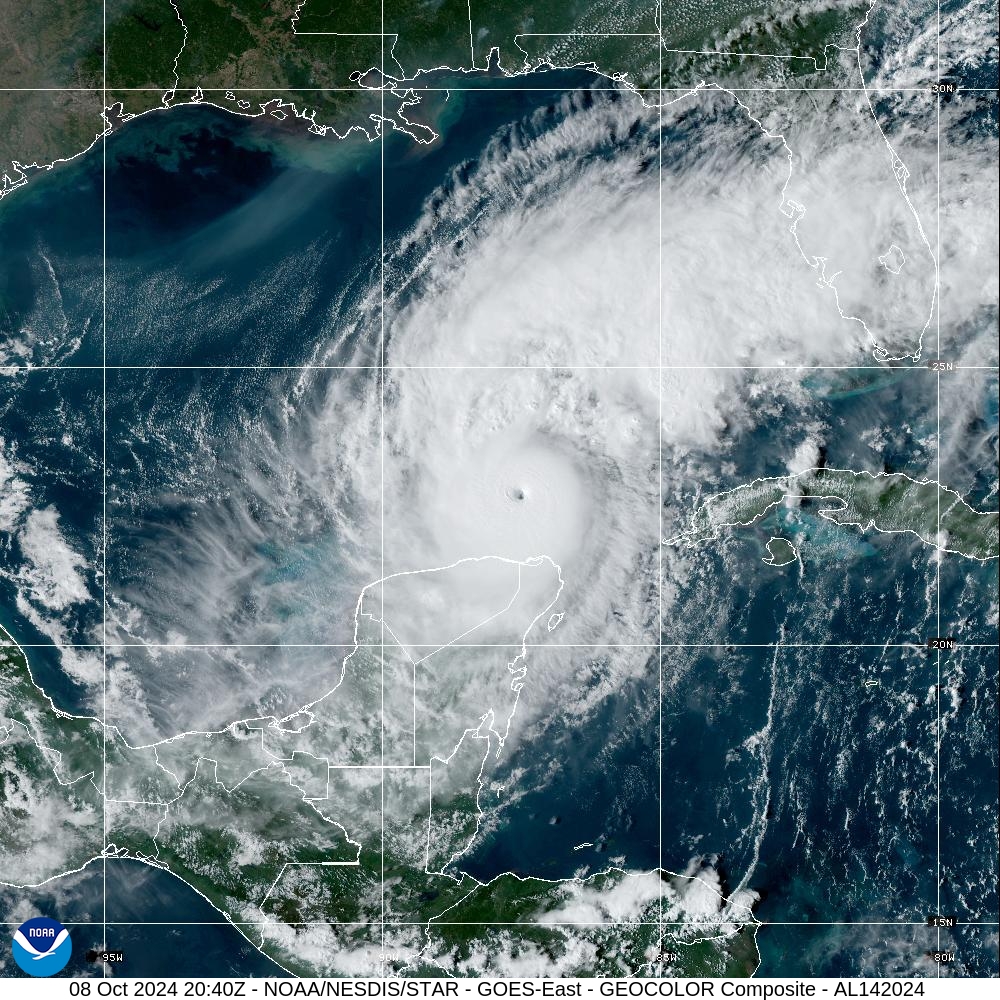
Image: Category 5 Hurricane Milton from the GOES-18 Satellite. Source: NOAA
Current Ocean temperatures around Australia
Ocean temperatures around northern Australia are following the global trend, largely being 1-2 degrees above the long-term average. Of note for the upcoming tropical cyclone season, Sea Surface Temperatures (SSTs) off the northwest shelf of Western Australia, the Joseph Bonaparte Gulf, and the southern part of the Gulf of Carpentaria, are already above 29°C.
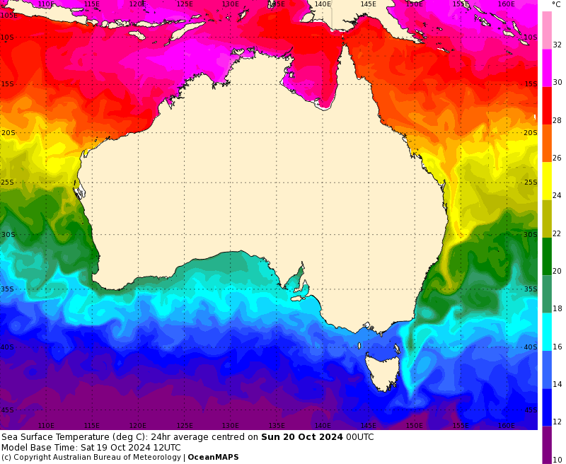
Image: SSTs around Australia on October 20, 2024. Waters in red and pink show areas that are at least 26°C, indicating that they likely can develop a tropical cyclone. Source: BoM
What is a severe tropical cyclone?
A severe tropical cyclone is a system that has reached category 3 or higher, equivalent to a typhoon or hurricane. Once a system reaches this strength, it develops a clear eye and has peak sustained winds of 118km/h or higher, typically with gusts in excess of 165km/h. In addition to the strong winds, severe tropical cyclones also can have very significant storm surges associated with them. Note that rainfall is mostly independent of category, so any tropical low or cyclone, regardless of category, can bring life-threatening flooding.
How common are severe tropical cyclones?
Historically, very close to half of all tropical cyclones in Australian waters become a severe tropical cyclone. Despite a slowly declining number of tropical cyclones in Australian waters over the last 50 years, the average proportion of severe tropical cyclones have stayed consistent at about 50%. Using the 1991-2020 climatology, the average number of tropical cyclones per season is 9-10, while the number of severe tropical cyclones averages is about 5 per season.
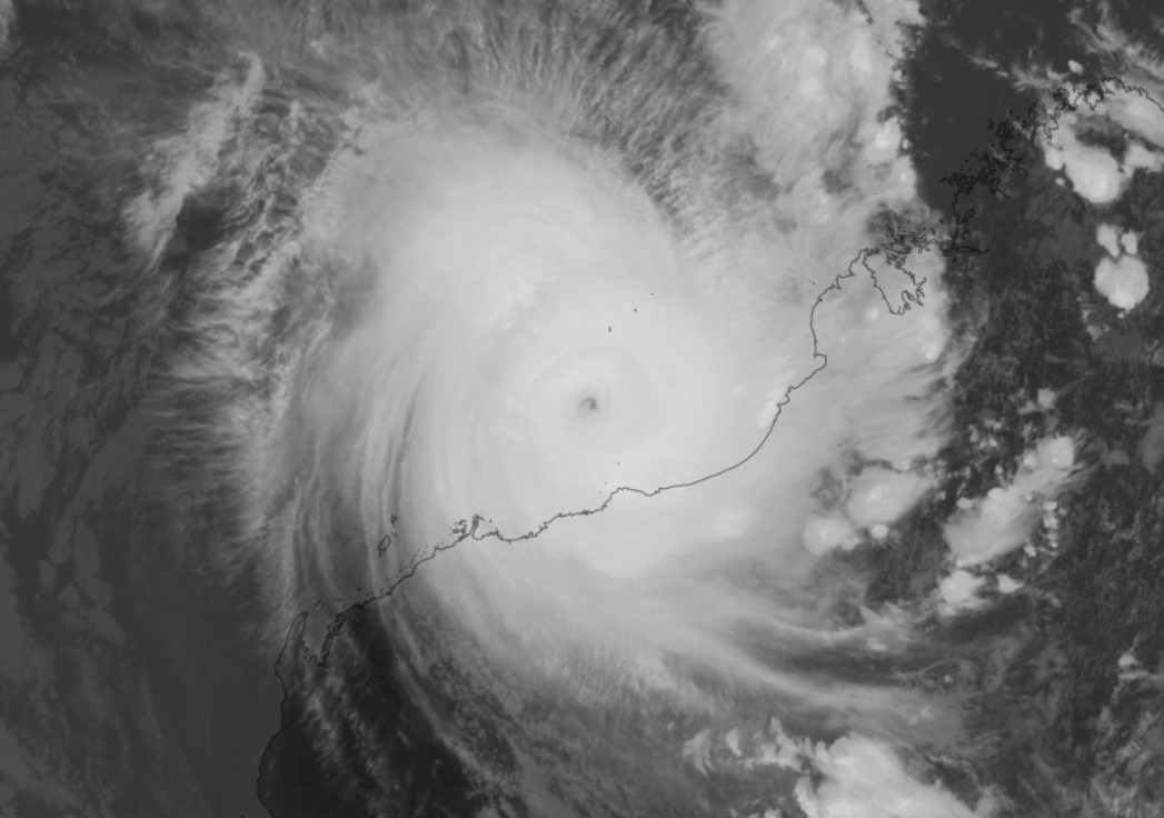
However, the last two seasons have seen a higher proportion of tropical cyclones than average. The 2022-23 season saw 5 out of 7 reach severe (including the record breaking Severe Tropical Cyclones Freddy and Ilsa), with 6 out of 8 tropical cyclones reaching severe in the 2023-24 season (including one of Australia’s wettest: Severe Tropical Cyclone Jasper).
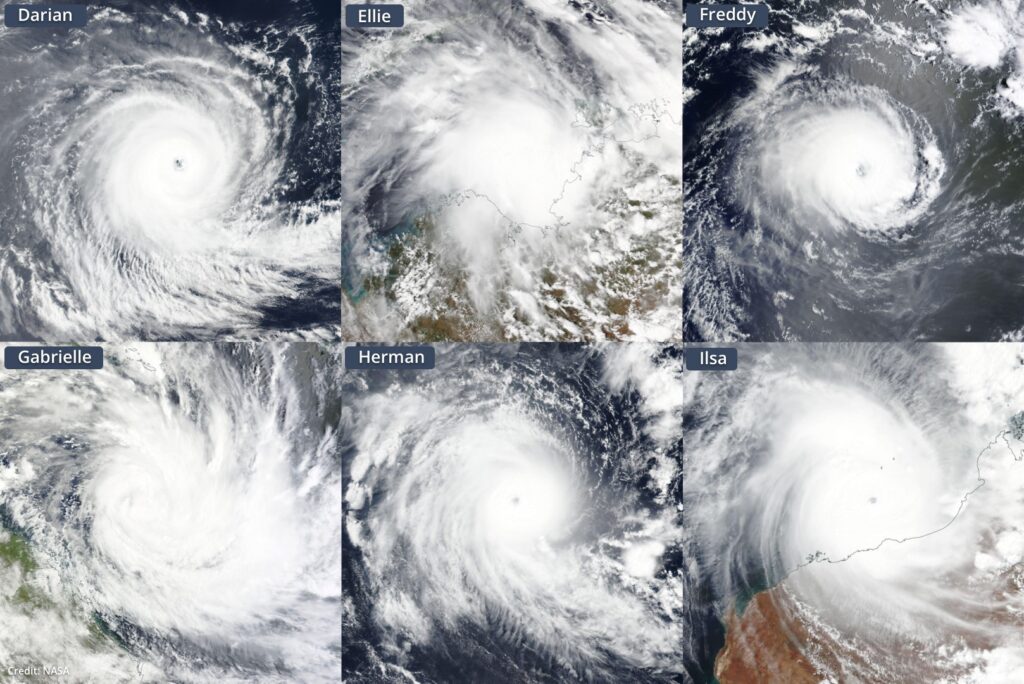
Image: Six tropical cyclones named inside Australia’s area of responsibility during the 2022-23 season.
The upcoming season
Forecasts of the 2024-25 tropical cyclone season show that an average number of tropical cyclones are expected in Australian waters, so around 9 or 10 systems. Following the trend from the last two seasons, as well as the global trend, a higher proportion of severe tropical cyclones are expected this season. With waters as warm as they are for the start of the season, we could see earlier severe tropical cyclones than normal as well.
Weatherzone provides our clients with detailed Tropical Cyclone, wet season, thunderstorm, heavy rainfall and extreme heat seasonal forecasts, helping businesses prepare for the upcoming cyclone season. For more information, please visit our website or email us at apac.sales@dtn.com.


